Central West (New South Wales) facts for kids
Quick facts for kids Central WestNew South Wales |
|||||||||||||||
|---|---|---|---|---|---|---|---|---|---|---|---|---|---|---|---|

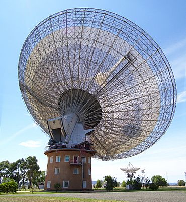
The CSIRO Radio Telescope at Parkes
|
|||||||||||||||
| Population | 212,962 (2021 census) | ||||||||||||||
| • Density | 3.81967/km2 (9.8929/sq mi) | ||||||||||||||
| Area | 55,754 km2 (21,526.7 sq mi) | ||||||||||||||
| Time zone | AEST (UTC+10) | ||||||||||||||
| • Summer (DST) | AEDT (UTC+11) | ||||||||||||||
| Location | 200 km (124 mi) W of Sydney | ||||||||||||||
| LGA(s) |
|
||||||||||||||
| State electorate(s) |
|
||||||||||||||
| Federal Division(s) | |||||||||||||||
|
|||||||||||||||
The Central West is a cool region in the middle of New South Wales, Australia. It's located west of Sydney, stretching from Lithgow in the east to Lake Cargelligo in the west. This area is famous for its amazing places like the Jenolan Caves near Oberon. You can also find beautiful farms, natural landscapes, and even wineries here!
Some of the main towns you'll find in the Central West include Bathurst, Orange, Mudgee, Lithgow, Parkes, and Cowra. The region covers a big area of about 63,262 square kilometers. A part of it, called the Central Tablelands, is in the eastern section. The area around Dubbo, known as the Orana, is also often considered part of the Central West.
Major towns like Bathurst, Cowra, Lithgow, Mudgee, Orange, and Parkes are important centers for people and services. Both Bathurst and Orange have campuses of Charles Sturt University, where students can study.
Contents
Towns and Cities in Central West
The Central West is home to several important towns and cities. The largest ones are Bathurst and Orange. Other well-known towns include Cowra, Mudgee, Lithgow, and Parkes.
There are also many smaller towns that make up this region, such as:
How Many People Live Here?
The Central West region is made up of several local government areas. Here's a look at how many people lived in each area in 2016:
| Central West rank | Local Government Area | Population as of 30 June 2016 | 10 year growth rate | Population density (people/km2) |
|---|---|---|---|---|
| 1 | Bathurst Regional | 42,389 | 14.8 | 11.1 |
| 2 | Orange City | 41,384 | 13.8 | 145.6 |
| 3 | Mid-Western Regional | 24,569 | 13.5 | 2.8 |
| 4 | Lithgow City | 21,524 | 6.6 | 4.8 |
| 5 | Parkes Shire | 14,946 | 2.4 | 2.5 |
| 6 | Cabonne Shire | 13,625 | 7.8 | 2.3 |
| 7 | Cowra Shire | 12,673 | -0.6 | 4.5 |
| 8 | Forbes Shire | 9,808 | 2.8 | 2.1 |
| 9 | Blayney Shire | 7,418 | 10.0 | 4.9 |
| 10 | Lachlan Shire | 6,352 | -7.0 | 0.4 |
| 11 | Oberon Shire | 5,399 | 4.2 | 1.5 |
| 12 | Weddin Shire | 3,692 | -0.8 | 1.1 |
| Central West | 209,810 | 8.5 | 3.0 | |
What's the Land Like?
The eastern part of the Central West is higher up, gets more rain, and has more hills. This is where you'll find fruit orchards, vineyards (where grapes for wine are grown), vegetable farms, and places where animals like sheep and cattle graze. The western part is flatter and drier. Here, farmers mostly grow grain crops and raise animals.
Main Roads
Several important highways run through the Central West region. These include the Great Western Highway, the Mid-Western Highway, the Mitchell Highway, the Newell Highway, and the Castlereagh Highway. These roads help people travel between towns and transport goods.
Media and News
The Central West has its own local radio stations and television channels. You can listen to various radio stations like 2BS 95.1FM and B-Rock FM. Major TV channels like ABC, Prime7, Nine, and Southern Cross 10 also broadcast here.
For news, there are two main newspapers: the Central Western Daily, published in Orange, and the Western Advocate, published in Bathurst. Many other smaller local papers keep residents informed about their towns.
A Look Back in Time
The Central West area was originally the home of the Wiradjuri people, who are Aboriginal people. They lived on this land for thousands of years.
The first British explorer to visit the area was George Wilson Evans in 1815. He explored the Lachlan Valley. Later, in the 1850s, many gold seekers traveled through the Central West. They were heading to gold fields like Lambing Flat (near Young) and Grenfell, hoping to find their fortune!
 | James Van Der Zee |
 | Alma Thomas |
 | Ellis Wilson |
 | Margaret Taylor-Burroughs |


