
Riverina facts for kids
Quick facts for kids RiverinaNew South Wales |
|||||||||||||||
|---|---|---|---|---|---|---|---|---|---|---|---|---|---|---|---|

The Murrumbidgee River at Wagga Wagga
|
|||||||||||||||
| Population | 255,881 (2001) | ||||||||||||||
| LGA(s) | Various | ||||||||||||||
| State electorate(s) |
|
||||||||||||||
| Federal Division(s) | |||||||||||||||
|
|||||||||||||||
The Riverina is a big farming area in the south-west of New South Wales, Australia. It has flat lands, a warm to hot climate, and lots of water for irrigation. This makes the Riverina one of Australia's most productive farming regions. It grows many different types of crops.
The Riverina is bordered by Victoria to the south. The mountains of the Great Dividing Range are to its east. This region covers parts of New South Wales that are within the Murray and Murrumbidgee river systems.
Aboriginal groups have lived in the Riverina for over 40,000 years. Europeans first settled here in the mid-19th century. They used the land for raising animals like beef cattle and sheep for wool. These products were sold in Australia and overseas. In the 20th century, large irrigation systems were built. This allowed farmers to grow new crops like rice and grapes. The Riverina has strong connections to Victoria. This region also played a big part in the push for the federation of Australian colonies.
The main cities and towns in the Riverina are Wagga Wagga, Albury, and Griffith. Both Albury and Wagga Wagga have campuses of Charles Sturt University. Wagga Wagga is also home to two major Australian Defence Force bases.
Contents
What is the Geography of the Riverina?

The exact size of the Riverina region can change. However, it usually includes the farming and animal-raising areas of New South Wales. These areas are west of the Great Dividing Range. They are also in the drainage basin of the Murray and Murrumbidgee Rivers. These rivers are fed by snow.
The northern edge of the Riverina is near the Lachlan River. This area is known as the Central West. To the south, along the Murray River, the Riverina borders the state of Victoria. West of where the Murray and Murrumbidgee rivers meet, the land becomes much drier. This is the start of the Far West region.
How Were the Riverina's Landforms Created?
The Riverina is mostly a flat plain. It was formed by soil carried from the Great Dividing Range. Streams brought this soil between 30,000 and 15,000 years ago. The eastern part of the region has rolling hills. But as you go west, the land becomes very flat. Most of this flat plain is less than 200 metres (660 ft) above sea level. The western Riverina is mainly a flat saltbush plain.
What About Water and Soil in the Riverina?

The Riverina's geology includes several deep areas called troughs and sedimentary basins. The western Riverina is believed to be the end of a geological zone from Ballarat and Bendigo. The eastern part sits over the western part of the Lachlan Fold Belt. It is possible that the Riverina has mineral deposits. These could include coal, petroleum, methane from coal seams, gypsum, gold, and other metals. There might also be heavy mineral sands and even diamonds in these rocks and basins.
The soils in the Riverina are generally sandy near the rivers. In areas that are rarely flooded, you can find more salty grey and brown clays. As the Murrumbidgee River flows further downstream, its water and the soil around it become more salty.
The Riverina is part of the large Murray-Darling Basin. Rivers and streams in the Riverina usually flow from east to west. Besides the Murray, Murrumbidgee, and Lachlan rivers, other streams include Billabong Creek and the Edward River. The Edward River is a branch of the Murray. A lot of the water from these streams is used for other purposes. For example, in 2001–2002, 52% of the water from the Murray and Murrumbidgee was taken. Of that, 77% was used for irrigation to help farms grow crops.
Images for kids
-
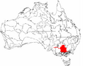
The IBRA regions, with the Riverina in red
-
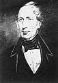
Charles Sturt, the first European to follow the Murrumbidgee River downstream to the Murray.
-
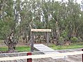
The Old Moulamein Wharf, on the Edward River, was built in 1908. Moulamein was a busy river port until railways arrived in 1926.
-
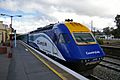
Junee railway station is a stop for the Melbourne XPT passenger train service.
-
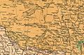
A 1916 map of the Riverina. The areas where Griffith and Leeton were later built were mostly empty until the Murrumbidgee Irrigation Area was developed.
-
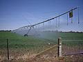
A centre pivot irrigation system near Euberta. Much of the farming in the Riverina needs irrigation.
-
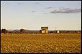
Burrandana Railway Station overlooking a field of wheat stubble, 1985.
-
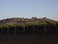
A vineyard located in Tumblong.
-
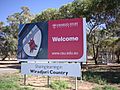
The entrance sign to the Wagga Wagga campus of Charles Sturt University. It honors the Wiradjuri people as the traditional owners.
-
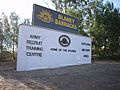
The Army Recruit Training Centre in Wagga Wagga. This is where almost all Australian army personnel start their training.
-
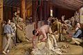
Shearing the Rams (1890). This famous painting was created by Tom Roberts. He spent time at Brocklesby station before painting it.


.jpg)


See also
 In Spanish: Riverina para niños
