
Charles Sturt facts for kids
Quick facts for kids
Charles Sturt
|
|
|---|---|
 |
|
| Born | 28 April 1795 India
|
| Died | 16 June 1869 |
Captain Charles Napier Sturt (born April 28, 1795 – died June 16, 1869) was a brave British explorer. He played a big part in the European exploration of Australia. Sturt led many trips into the middle of Australia. He started from both Sydney and later from Adelaide. His journeys helped map many rivers that flowed west. He found that all these rivers joined together to form the mighty Murray River. Sturt was also looking for a huge "inland sea" that people thought might be in the middle of Australia.
Contents
- Early Life and Army Days
- Discovering the Darling River
- Journey to the Murray River
- Exploring from Adelaide: Sturt's Last Big Trip
- Life After the Army
- Becoming a Farmer and Government Worker
- Central Australian Expedition 1844: Challenges and Discoveries
- Later Life and Legacy
- Sturt Remembered Today
- Images for kids
- See also
Early Life and Army Days
Charles Sturt was born in Bengal, India. His father was a judge there. Charles went to school in England. In 1813, he joined the British Army. He served as a soldier in France and Ireland. In 1826, Sturt returned to England. Soon after, he was sent to Australia. His job was to look after a group of convicts.
Discovering the Darling River
People in Australia wondered where the western rivers went. They thought these rivers might flow into an inland sea. Another explorer, John Oxley, had been stopped by a marsh (swampy land). He thought this marsh was the edge of the sea.
Sir Ralph Darling, who was the Governor of New South Wales, had an idea. He thought it would be easier to explore during a drought. A drought is a long time without rain. This would make the swamps dry. Governor Darling put Sturt in charge of a new trip.
On November 10, 1828, Sturt and 13 men began their journey. Explorer Hamilton Hume was one of them. They followed the Macquarie River, then the Bogan River and the Castlereagh River. They soon found a new river. Sturt named it the Darling River after the Governor. They followed the Darling River for about 100 km (62 mi). This was near the town of Bourke today. After that, they went back to Sydney.

Journey to the Murray River
On November 3, 1829, Sturt led another group of eight men. Their goal was to follow the Murrumbidgee River. Governor Darling wanted to know where this river went. He also wanted to see if it joined the Lachlan River.
They traveled west from Sydney. They reached the Murrumbidgee River near Jugiong. They followed the river bank until they reached the Lachlan River. From there, Sturt used a small boat. He traveled down the Murrumbidgee River. On January 14, 1830, he reached the Murray River.
This river had been found six years earlier by Hamilton Hume and William Hovell. They had named it the Hume River. But Sturt, hoping for a reward, renamed it. He called it the Murray River after Sir George Murray, a British politician.
After a few days, they found a large river joining the Murray from the north. Sturt correctly guessed this was the Darling River. He put up a flag pole and raised the British flag, the Union Jack. His men gave three loud cheers.
The group kept going down the river. On February 9, 1830, they reached Lake Alexandrina. Sturt named it after Princess Alexandrina, who later became Queen Victoria. After finding where the Murray River met the sea, they had a hard trip back. They had to row the boat upstream. They left the river near Narrandera on April 11, 1830. They walked back to Sydney, arriving on May 25, 1830.
Sturt became very sick after this trip. He even became nearly blind.
Exploring from Adelaide: Sturt's Last Big Trip

Sturt strongly believed he would find a large salt lake. He thought this "inland sea" was in the middle of Australia. He also wanted to be the first to reach the very center of the continent.
In August 1844, he started his third big journey. He had 15 men, 200 sheep, six drays (carts), and a boat. They planned to explore north-western New South Wales and go into central Australia. They traveled along the Murray River and Darling River. They passed the future site of Broken Hill.
But then, extreme summer heat stopped them for months. They were stuck near Milparinka. When the rains finally came, Sturt moved north. He set up a supply camp called Fort Grey. This is in today's Sturt National Park.
Sturt took a small group of men, including John McDouall Stuart. Stuart was the map-maker. They pushed on across Sturt's Stony Desert and into the Simpson Desert. But they could not go any further. Sturt had to turn back to Fort Grey.
Sturt tried a second time to reach the center of Australia. But he got scurvy because of the harsh conditions. His health got very bad. He had to give up the attempt. John Harris Browne, the expedition's doctor, helped Sturt. He took over leading the group. After traveling 3000 km (1864 mi), he brought everyone back safely.
Life After the Army
In August 1830, Sturt was sent to Norfolk Island for military duty. Norfolk Island was a penal colony. This was a place where very difficult prisoners were sent. He stayed there until January 1832. Then he went back to Sydney.
Sturt could not get more important work. His eyesight was still not good. So, he went to England and left the army in July 1833. He wrote a book about his trips. It was called Two Expeditions into the Interior of Southern Australia, 1828—1831.
Sturt was given 5000 acres (2023 ha) of land in New South Wales as a reward. In September 1834, he sailed back to Sydney with his new wife, Charlotte Green.
Becoming a Farmer and Government Worker
When Sturt returned to Australia, he started farming. He took up land near Canberra. Then he had land at Mittagong. In 1837, he moved to Varroville, a farm near Liverpool.
In 1838, Sturt moved a herd of cattle overland to Adelaide. He did more exploring around Adelaide. This included a trip back to Lake Alexandrina. He also went north to St.Vincent's Gulf. He moved his family to Adelaide in 1839.
Sturt was made the Surveyor General (the person in charge of surveying). This was by the Governor of South Australia. But a new surveyor arrived who had been chosen by the government in England. So, Sturt worked as Assistant Land Commissioner. This job was later abolished (ended) by England. For a short time, he worked as the Registrar-General. But this job paid less money.
Sturt was not happy. He hoped a new expedition would help him get a better job. He still wanted to go into the middle of Australia. He wanted to look for an inland sea. Another explorer, Edward John Eyre, had found his path north blocked. He thought it was a huge salt lake shaped like a horseshoe. It was actually six large dry salt lakes. Sturt hoped he could go around these lakes by going farther to the east.
Central Australian Expedition 1844: Challenges and Discoveries
Depot Glen Camp
-

Sturt leaving Adelaide in 1844
-
The waterhole at Depot Glen
-
The cairn on Mount Poole
-
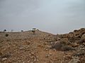
View of the cairn on Mount Poole
-
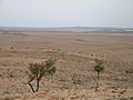
View of Preservation Creek and Depot Glen from Mount Poole
-
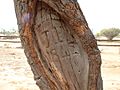
Carved tree marking Poole's grave, 1845


Sturt and 16 men left Adelaide on August 15, 1844. They had 11 horses, 200 sheep, 32 bullocks, six dogs, many carts, wagons, and a boat. They followed the Darling River north to Menindee Laidley's Ponds.
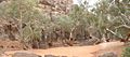
On January 15, 1845, the group reached a waterhole. It was 16 km (10 mi) west of Milparinka today. They called this creek Preservation Creek. Their camp by the waterhole was named Depot Glen.
It was very hot and dry due to a drought. Sturt decided to rest the expedition there for six months. They dug an underground room to escape the heat. It was so hot that the lead fell out of their pencils. The wood of their equipment boxes shrank so much that screws fell out.
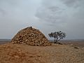
The second-in-charge, an Irish surveyor named James Poole, died from scurvy. His grave can still be seen. Sturt and his men built a large pile of rocks, called a cairn, on top of Mount Poole. John McDouall Stuart became second-in-charge. When Sturt's eyesight got worse, Stuart took over drawing the maps.
Fort Grey and the Stony Desert
Sturt divided the group. One part went back to Adelaide. After some rain, Sturt moved the other group west. They went to a waterhole on Frome Creek, which they named Fort Grey.
His path west was blocked by a dry salt lake, Lake Blanche. So, he took a small group north-west. They went between Cooper Creek and the Diamantina River. Here, he found a desert of stones, called gibbers. It was very hard to cross. The stones hurt the feet of the horses and bullocks. This desert is now called Sturt's Stony Desert.
By September 1845, he had reached the Simpson Desert. He could not go any farther. He went back 713 km (443 mi) to Fort Grey.
He then tried to go north. He got close to Birdsville. But again, the Stony Desert stopped him. It was extremely hot. His thermometer burst at 53 degrees Celsius. Sturt decided to go back to Adelaide. He was so sick that he could not ride. He had to be carried in a cart. They arrived back on January 19, 1846. Sturt was sad because he had not found an inland sea. He also had not reached the center of Australia.
Later Life and Legacy
In February 1846, Sturt became Colonial Treasurer. He also received a gold medal from the Royal Geographical Society. He went to England and wrote another book. It was called Narrative of an Expedition into Central Australia. Then he went back to Adelaide. He became a member of the South Australian parliament.
He retired from work at the end of 1851. In 1853, he took his family back to England. He asked to be made Governor of Victoria. Later, he asked to be Governor of Queensland. But neither happened.
Charles Sturt died suddenly in 1869. This was just after he was nominated for a British knighthood called K.C.M.G.
Sturt Remembered Today

Charles Sturt is still remembered in Australia. Many memorials, rock cairns, and signs show the places he explored. Two plants were named after him:
- Sturt's Desert Pea (Swainsona formosa), which is the flower symbol of South Australia.
- Sturt's Desert Rose (Gossypium sturtianum), which is the flower symbol of the Northern Territory.
Sturt found the Desert Pea plant in creeks near Broken Hill, New South Wales in 1844. He collected its seeds. He brought them back for Robert Brown, a Scottish botanist, to study.
The Sturt Highway is a major road. It connects Sydney and Adelaide.
The Charles Sturt University is a large university. It has campuses in country New South Wales. These are in Albury, Bathurst, Dubbo, Orange, and Wagga Wagga.
The Sturt National Park is a huge park. It is in the north-west corner of New South Wales. The park covers 340,000 hectares (840,158 acres) of semi-desert land. Several historic Sturt sites are in the park, including Fort Grey.
Images for kids
-
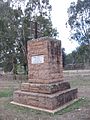
Sturt memorial at Narrandera on the Murrumbidgee River.
-
Charles Sturt monument in Merbein, Victoria.


See also
 In Spanish: Charles Sturt para niños
