
European exploration of Australia facts for kids

The European exploration of Australia started in February 1606. A Dutch sailor named Willem Janszoon landed on the Cape York Peninsula. Later that year, in October, a Spanish explorer, Luís Vaz de Torres, sailed through the Torres Strait islands.
Many other Dutch sailors explored the western and southern coasts in the 1600s. They called the continent "New Holland". More European explorers came after them.
In 1770, Lieutenant James Cook mapped the east coast of Australia for Great Britain. He reported that Botany Bay (near modern-day Sydney) would be a good place for a colony.
In January 1788, a group of British ships called the First Fleet arrived at Botany Bay. They came to set up a penal colony, which was a place where criminals were sent. This was the first British colony on the Australian mainland. Over the next 100 years, the British started more colonies across the continent. European explorers also traveled into Australia's center.
During this time, Indigenous Australians faced many challenges. New diseases brought by Europeans made many people sick. There was also conflict with the colonists. This caused the number of Indigenous Australians to decrease. Large areas of land were cleared for farming and other uses. This changed the environment and reduced the food and resources Indigenous Australians relied on. They were forced into smaller areas. There was resistance from Indigenous Australians against the settlers. Fighting happened between 1788 and the 1920s.
Contents
Who First Explored Australia?
Dutch explorers were the first Europeans to officially see and land on the Australian mainland in 1606. The ship and crew that first mapped part of the Australian coast and met Aboriginal people was the Duyfken. Its captain was Willem Janszoon. He saw the coast of Cape York Peninsula in early 1606. He landed on February 26 near the Pennefather River, close to the town of Weipa.
The Dutch mapped the entire western and northern coastlines. They named the continent "New Holland" during the 1600s. However, they did not try to settle there. William Dampier, an English explorer, landed on the north-west coast of New Holland in 1688. He returned again in 1699.
The Dutch often sailed to the Dutch East Indies for trade. They also looked for gold, spices, or people to convert to Christianity. These voyages helped Europe learn a lot about Australia's coast. In 1616, Dirk Hartog landed on an island off Shark Bay in Western Australia. He was sailing off course from the Cape of Good Hope to Batavia.
In 1622–23, the ship Leeuwin was the first to sail around the southwest corner of the continent. It gave its name to Cape Leeuwin. In 1627, François Thijssen accidentally found the south coast of Australia. He named it 't Land van Pieter Nuyts. This was in honor of Pieter Nuyts, an important passenger.
In 1628, Dutch ships explored the northern coast. They examined the Gulf of Carpentaria closely. This gulf was named after Pieter de Carpentier, the Governor-General of the Dutch East Indies.
Abel Tasman's journey in 1642 was the first European trip to reach Van Diemen's Land (now Tasmania) and New Zealand. He also saw Fiji. On his second trip in 1644, he helped map Australia. He made notes about the land and people of the north coast below New Guinea.
By 1655, a map in the Amsterdam Town Hall showed how much of Australia's coast the Dutch had charted. This map included Tasman's discoveries. In 1664, the French mapmaker Melchisédech Thévenot published a map of New Holland. He divided the continent into "Nova Hollandia" in the west and "Terre Australe" in the east.
In 1770, James Cook sailed along and mapped the east coast. He named it New South Wales and claimed it for Great Britain.
How Did British Colonies Start in Australia?
After losing its American colonies in 1783, the British Government looked for new places to settle. They sent a group of ships called the "First Fleet". Captain Arthur Phillip led them. Their goal was to start a new penal colony in New South Wales.
On January 26, 1788, they set up camp and raised the flag at Sydney Cove, Port Jackson. This date is now Australia Day, Australia's national day. Phillip sent teams to find better farming land. They chose the Parramatta area. Many convicts were moved there from late 1788 to start a small town. This town became the main center of the colony's economy.
Seventeen years after Cook mapped the east coast, the British decided to start a colony at Botany Bay. After the American Revolutionary War (1775–1783), Britain lost most of its land in North America. They needed new places. In 1779, Joseph Banks, a famous scientist who sailed with James Cook, suggested Botany Bay. He said that a land as big as New Holland, "larger than the whole of Europe," would be very useful.
Georg Forster, who sailed with James Cook, wrote in 1786 about the future of the British colony. He said that New Holland, "an island of enormous extent or it might be said, a third continent," would be the home of a new society. He believed it would become very important.
Britain claimed all of Australia east of the 135° East line of longitude. They also claimed all islands in the Pacific Ocean between Cape York Peninsula and the southern tip of Van Diemen's Land (Tasmania). This was a huge claim.
A British settlement was started in 1803 in Van Diemen's Land, now called Tasmania. It became a separate colony in 1825. The United Kingdom officially claimed the western part of Western Australia (the Swan River Colony) in 1828.
New colonies were created from parts of New South Wales. South Australia was founded in 1836. Victoria was founded in 1851. Queensland was founded in 1859. The Northern Territory was created in 1911 from South Australia.
South Australia was a "free province." This means it was never a penal colony. Victoria and Western Australia also started as "free" colonies. But they later accepted transported convicts because they needed more workers. The settlers in New South Wales campaigned to stop convicts from being sent there. The last convict ship arrived in 1848.
Exploring Australia's Vast Interior
Mapping the Coasts and Tasmania
In 1798–99, George Bass and Matthew Flinders sailed from Sydney. They went around Tasmania, proving it was an island. This happened after an attempt to settle at Sullivan Bay in what is now Victoria.
In 1801–02, Matthew Flinders led the first trip around all of Australia in HMS Investigator. An Aboriginal explorer named Bungaree, from the Sydney area, was on board. He became the first person born on the Australian continent to sail all the way around it. Before this, Bennelong and a friend were the first people born in New South Wales to sail to Europe. They went with Governor Phillip to England in 1792 and met King George III.
Crossing the Blue Mountains
In 1813, Gregory Blaxland, William Lawson, and William Wentworth successfully crossed the difficult Blue Mountains west of Sydney. These mountains had thick forests and steep cliffs. At Mount Blaxland, they saw "enough grass to support the stock of the colony for thirty years." This meant the British settlement could expand into the inland areas.
Discovering Rivers and New Lands
In 1824, Governor Thomas Brisbane asked Hamilton Hume and William Hovell to find new grazing land in the south. They also wanted to know where New South Wales' western rivers flowed. Over 16 weeks in 1824–25, Hume and Hovell traveled to Port Phillip and back. They made important discoveries. These included the Murray River (which they named the Hume) and its smaller rivers. They also found good farming and grazing lands between Gunning, New South Wales and Corio Bay, Port Phillip.
Charles Sturt led a trip along the Macquarie River in 1828. He was the first European to find the Darling River. People thought that the inland rivers of New South Wales flowed into an inland sea. In 1829, Sturt led another trip. He followed the Murrumbidgee River into a "broad and noble river," the Murray River. He named it after Sir George Murray. His group followed this river to where it met the Darling River. They had two tense meetings with local Aboriginal people. Sturt continued downriver to Lake Alexandrina, where the Murray River meets the sea in South Australia. The group suffered greatly and had to row hundreds of kilometers back upstream to return.
Surveyor General Sir Thomas Mitchell led several trips from the 1830s. He wanted to "fill in the gaps" left by earlier trips. He carefully recorded the original Aboriginal place names around the colony. Because of this, most place names today still have their Aboriginal names.
New Settlements and High Peaks
In 1836, two ships from the South Australia Land Company left to start the first settlement on Kangaroo Island. The official start of South Australia is celebrated on December 28, 1836. This is when Governor John Hindmarsh announced the new Province at Glenelg on the mainland.
The Polish scientist and explorer Count Paul Edmund Strzelecki surveyed the Australian Alps in 1839. He was the first European to climb Australia's highest peak. He named it Mount Kosciuszko to honor the Polish hero Tadeusz Kościuszko.
Other British settlements were started around the continent. Many of them did not last. In 1823, the East India Trade Committee suggested a settlement on Australia's northern coast. This was to prevent the Dutch from settling there. Captain J.J.G. Bremer was asked to form a settlement between Bathurst Island and the Cobourg Peninsula. Bremer chose the site of his settlement at Fort Dundas on Melville Island in 1824. This was west of the boundary claimed in 1788. So, he claimed British rule over all land as far west as 129° East longitude.
This new boundary included Melville and Bathurst islands and the nearby mainland. In 1826, the British claim was extended to the whole Australian continent. Major Edmund Lockyer started a settlement on King George Sound (which later became Albany). But the eastern border of Western Australia stayed at 129° East longitude.
In 1824, a penal colony was started near the mouth of the Brisbane River. This later became the colony of Queensland. In 1829, the Swan River Colony and its capital, Perth, were founded on the west coast. It also took control of King George Sound. Western Australia started as a free colony. But it later accepted British convicts because it needed more settlers and workers.
The colony of South Australia was settled in 1836. Its western and eastern borders were set at 132° and 141° East of Greenwich. Its northern border was at 26° South latitude. These borders were chosen based on the coastline Matthew Flinders surveyed in 1802. The British Parliament set the northern border at 26° South. They believed this was the limit of how far a settlement on the shores of Gulf St Vincent could control land.
Exploring the Outback
European explorers made their last big, often difficult, and sometimes sad trips into the interior of Australia in the second half of the 1800s. Some trips were supported by the government. Others were paid for by private investors. By 1850, large parts of the inland were still unknown to Europeans.
Explorers like Edmund Kennedy and Ludwig Leichhardt died trying to explore in the 1840s. But explorers still wanted to find new land for farming or answer scientific questions. Surveyors also acted as explorers. The colonies sent out trips to find the best routes for communication lines. The size of these trips varied. Some were small, with only two or three people. Others were large, well-equipped teams led by gentlemen explorers. They had help from smiths, carpenters, laborers, and Aboriginal guides. They used horses, camels, or bullocks.
From 1858 onwards, "Afghan" cameleers and their camels were very important. They helped open up the outback and build new roads and other structures.
In 1860, the Burke and Wills trip was the first to cross the continent from south to north. They went from Melbourne to the Gulf of Carpentaria. Burke and Wills were not good at bushcraft. They also did not want to learn from the local Aboriginal people. They died in 1861. They had returned from the Gulf to their meeting point at Cooper Creek. But they found that the rest of their group had left just hours before. The trip was a great feat of navigation. But it was also a huge organizational disaster. It continues to interest the Australian public.
In 1862, John McDouall Stuart successfully crossed Central Australia from south to north. His trip mapped the route that the Australian Overland Telegraph Line later followed.
Uluru and Kata Tjuta were first mapped by Europeans in 1872. This happened during the exploration period made possible by the Australian Overland Telegraph Line. In separate trips, Ernest Giles and William Gosse were the first European explorers to this area. While exploring in 1872, Giles saw Kata Tjuta from near Kings Canyon. He called it Mount Olga. The next year, Gosse saw Uluru and named it Ayers Rock. This was to honor Sir Henry Ayers, the Chief Secretary of South Australia. These dry desert lands of Central Australia disappointed the Europeans. They thought the land was not good for farming. But these places later became symbols of Australia.
Images for kids
-
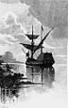
19th-century artist impression of the ship Duyfken in the Gulf of Carpentaria.
-
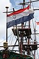
Replica of an East Indiaman of the Dutch East India Company/United East India Company (VOC).
-

The Wiebbe Hayes Stone Fort on West Wallabi Island is the first known European structure to be built in Australia
-
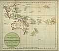
A General Chart of New Holland including New South Wales & Botany Bay with The Adjacent Countries and New Discovered Lands, published in An Historical Narrative of the Discovery of New Holland and New South Wales, London, Fielding and Stockdale, November 1786
-
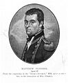
Matthew Flinders led the first successful circumnavigation of Australia.
-
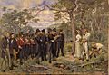
The Foundation of Perth 1829 by George Pitt Morison
-
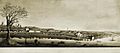
Melbourne Landing, 1840; watercolour by W. Liardet (1840)
-
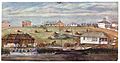
Brisbane (Moreton Bay Settlement), 1835; watercolour by H. Bowerman
-
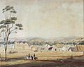
Adelaide in 1839. South Australia was founded as a free colony, without convicts.
.jpg)


