
Albany, Western Australia facts for kids
Quick facts for kids AlbanyWestern Australia |
|||||||||
|---|---|---|---|---|---|---|---|---|---|

York Street in Albany
|
|||||||||
| Lua error in Module:Location_map at line 416: Malformed coordinates value. | |||||||||
| Population | 35,053 (2021) (44th) | ||||||||
| • Density | 117.944/km2 (305.47/sq mi) | ||||||||
| Established | 26 December 1826 | ||||||||
| Postcode(s) | 6330 | ||||||||
| Elevation | 26 m (85 ft) | ||||||||
| Area | 297.2 km2 (114.7 sq mi)(2011 urban) | ||||||||
| Time zone | AWST (UTC+8) | ||||||||
| Location | |||||||||
| LGA(s) | City of Albany | ||||||||
| State electorate(s) | Albany | ||||||||
| Federal Division(s) | O'Connor | ||||||||
|
|||||||||


Albany (pronounced AL-bən-ee) is a port city in the Great Southern region of Western Australia. It is about 418 kilometers (260 miles) southeast of Perth, the state capital. The city center is located on the northern side of Princess Royal Harbour, which is part of King George Sound. Mount Clarence is to the east of the city, and Mount Melville is to the west. Albany is managed by the local government area called the City of Albany.
Albany is the oldest European settlement in Western Australia. It was founded on December 26, 1826, as a military outpost by New South Wales. This was done to stop the French from claiming the area. On January 21, 1827, Major Edmund Lockyer officially claimed the western part of New Holland for the British Crown. For a few years, Albany was like a separate part of New South Wales before it became part of the Swan River Colony.
In the late 1800s, Albany was a key entry point for people heading to the Eastern Goldfields to find gold. For many years, it was the only deep-water port in the colony, important for ships traveling between Britain and Australia. However, when the Fremantle Inner Harbour opened in 1897, Albany's importance as a port decreased. After that, the city focused more on farming, timber, and later, whaling.
Today, Albany is a popular starting point for tourists exploring the region and the southwest of the state. People love it for its beautiful natural environment and historic sites. Albany also plays a special role in the ANZAC legend. It was the last stop for Australian and New Zealand (ANZAC) troops leaving for the First World War. On November 1, 2014, the National Anzac Centre opened in Mount Clarence, Albany. This center remembers 100 years since the first ANZAC troops left from King George Sound. Around 40,000 people attended the special events held from October 30 to November 2, 2014.
During the Second World War, an auxiliary submarine base was built in Albany for the US Navy's 7th Fleet. This was a backup in case the main submarine base in Fremantle was lost. The Royal Australian Navy also had a base in the harbor for refueling ships.
Contents
- What's in a Name? The Story of Albany's Name
- Albany's Early History
- Historic Buildings in Albany
- Albany's Population and People
- Geography of Albany
- What Does Albany Produce? Industries and Economy
- Getting Around Albany: Transport Options
- Media in Albany: News and Entertainment
- Sports and Recreation in Albany
- Education in Albany
- Local Areas in Albany
- Images for kids
- See also
What's in a Name? The Story of Albany's Name
When it was first settled in 1826, the town was called Frederick Town. This name honored Prince Frederick, Duke of York and Albany. In 1831, the settlement became part of the Swan River Colony. At that time, Lieutenant-Governor James Stirling renamed it Albany.
The local Nyungar language name for the area, used by the Menang people, is Kinjarling. This name is said to mean "place of plenty" or "place of rain." In 2020, the City of Albany started a project to highlight Kinjarling as the city's Aboriginal name.
Albany's Early History
The Kinjarling area was a summer home for the Menang Noongar tribes. Early British explorers found evidence of fish traps there. These were located at Emu Point and on the French River, now known as the Kalgan River. George Vancouver tried to meet the local people but only found empty bark shelters. Later explorers did make contact. At first, they were told to leave, but they were accepted when they stayed. Most British exploration focused on surveying the land and sea to find valuable resources. Explorers sometimes wrote about meeting Noongars. Laws and programs about how to treat native people have affected the tribes since the time of European settlement.
Historic Buildings in Albany
Albany has many important old buildings. You can find more details in List of heritage places in the City of Albany and Category:Heritage places in Albany, Western Australia. Here are some of them:
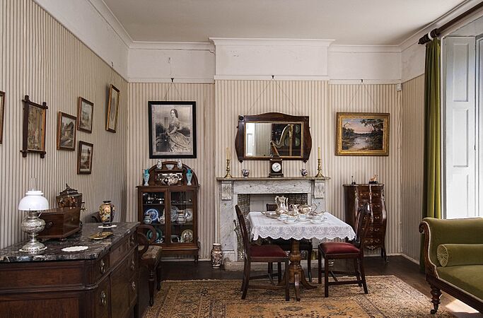
- The Old Farm, Strawberry Hill was started in 1827. It was a government farm that provided food for the soldiers stationed around King George's Sound. This makes it the oldest farm in Western Australia. The main house became the home of the local government leader in 1833. It is a good example of a colonial gentleman's house. After a long history, the property was given to the National Trust WA in 1964. Now, it is a museum where you can see how people lived long ago.
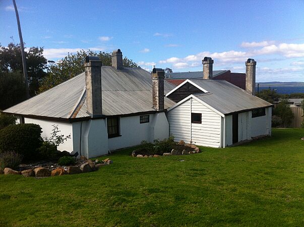
- Patrick Taylor Cottage was built in 1832 by the Morley Brothers. It is the oldest house still standing in Western Australia. The Albany Historical Society now takes care of it.
- St John's Church was built between 1841 and 1848. It is a stone building with a shingled roof. It was designed to look like an old English garden scene.
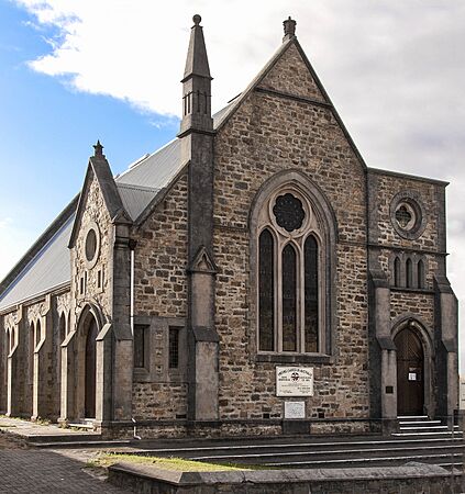
- Scots Uniting Church was designed in 1892 by architect Evander McIver from Melbourne. It was built using local granite stone.
- The building now known as The Residency Museum was first used in 1850. It was a depot for convicts in Albany. It is a single-story stone building with a timber roof. In 1873, it was changed into the home of the local judge. Today, it serves as a museum.
- The Town Hall was built in 1888. It is a two-story stone building with a tall clock tower. It stands out on York Street, which is Albany's main street. It has been used for many things, including council meetings, public events, and even the first regional meeting of the State Parliament.
- The Old Post Office was built in two parts. The first part was designed in 1869, and the second part, including its tall tower, was designed in 1896. It now houses the Albany campus of the University of Western Australia.
- The Court House was built in 1897. It is made of Albany brick and granite with a tiled roof.
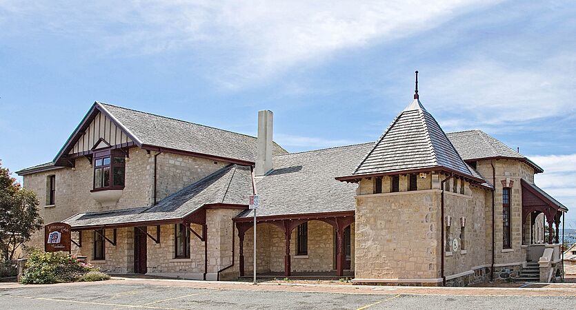
- Another important building is the Cottage Hospital. It was designed in 1886 and finished in 1897. It is one of the oldest hospitals in the state and was used as a hospital until 1962. Now, it is home to the Vancouver Arts Centre, named after the explorer George Vancouver.
- Images of heritage buildings
-
Old Farm, drawing room
-
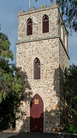
St.John's Church tower
-
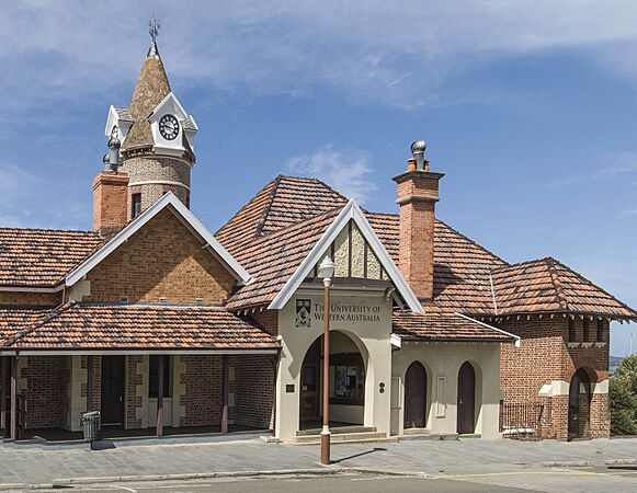
Old Post Office, north front
-
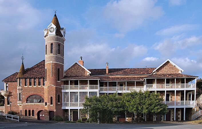
Old Post Office, south front
-
Scots Uniting Church
-
Vancouver House, formerly the Cottage Hospital
-
Patrick Taylor Cottage, Duke Street


Albany's Population and People
According to the 2021 census, Albany's urban population was 35,053 people. This makes it the sixth-largest population center in Western Australia.
Here's a look at the people who live in Albany:
- About 4.1% of the population are Aboriginal and Torres Strait Islander people.
- Most people (75.5%) were born in Australia. The next most common countries of birth were England (7.2%), New Zealand (1.7%), and the Philippines (1.7%).
- English is spoken at home by 87.7% of people. Other languages spoken include Filipino (0.6%), Tagalog (0.6%), and Afrikaans (0.6%).
- The most common religions are Anglican (11.9%) and Catholic (10.7%). Nearly half of the people (49.9%) reported having no religion.
Geography of Albany

The center of Albany is nestled between two hills, Mount Melville and Mount Clarence. These hills overlook Princess Royal Harbour. Many beaches surround Albany, with Middleton Beach being the closest to the town center. Other popular beaches include Frenchman Bay and Muttonbird Island.
Albany is located about 418 kilometers (260 miles) southeast of Perth, the state capital. The Albany Highway connects the two cities.
Wine Region
Albany is part of the Great Southern wine region in Western Australia. This area is known for producing various types of wine.
Albany's Coastline
_Westall.jpg)
.jpg)
The coastline around Albany is known for its rugged beauty. Sometimes, large waves called king waves can be dangerous, washing people off rocks. However, there are many safe and enjoyable beaches.

Betty's Beach was named after Betty Jones, who used to camp there with her family. It was first called Betty's Bay.
Frenchman Bay Beach is next to the Torndirrup National Park. It was originally called Quarantine Bay because a quarantine station was set up there in 1826.
Misery Beach is about 20 kilometers (12 miles) south of Albany. It got its name because of the whaling station that operated nearby until 1978. The whaling station caused waste to wash ashore, staining the sand and water red. Despite its name and history, Misery Beach was named Australia's Best Beach in 2022 by Tourism Australia. It was described as having "uncrowded, crystal-white sand, turquoise waters and a very dramatic granite backdrop."
Other beautiful beaches in the area include:
- Emu Point
- Gull Rock Beach (also known as Boiler Beach)
- Middleton Beach
- Nanarup Beach
- Muttonbird Beach
- Cosy Corner
- Two Peoples Bay, which includes Little Beach and Waterfall Beach
Albany's Climate
Albany has a warm-summer Mediterranean climate. This means it has dry, warm summers, mild and wet winters, and pleasant springs and autumns. Summers can have short periods of very hot weather, but cool ocean breezes often bring relief, especially in the evenings. Albany is known as the "Rainbow Coast" because it often has both sun and light rain or showers on the same day.
July is usually the wettest month, with an average of 144 millimeters (5.7 inches) of rain. During winter, it rains on about two out of every three days. February is the driest month, with an average of 22.9 millimeters (0.9 inches) of rain.
Albany experienced a record amount of rain on November 20, 2008. Violent storms hit the region, and the town flooded after 113.8 millimeters (4.48 inches) of rain fell in just 24 hours. This was the highest amount recorded since rainfall records began in 1877. The wettest month ever recorded was June 1920, with 292.8 millimeters (11.53 inches) of rain. February 1877 and February 1879 are the only months on record with no rain at all.
| Climate data for Albany (35°02′S 117°53′E / 35.03°S 117.88°E), 1991–2020, extremes since 1880 | |||||||||||||
|---|---|---|---|---|---|---|---|---|---|---|---|---|---|
| Month | Jan | Feb | Mar | Apr | May | Jun | Jul | Aug | Sep | Oct | Nov | Dec | Year |
| Record high °C (°F) | 41.7 (107.1) |
44.8 (112.6) |
40.8 (105.4) |
37.7 (99.9) |
35.2 (95.4) |
24.6 (76.3) |
23.3 (73.9) |
27.3 (81.1) |
30.6 (87.1) |
36.2 (97.2) |
41.1 (106.0) |
42.2 (108.0) |
44.8 (112.6) |
| Mean daily maximum °C (°F) | 22.6 (72.7) |
22.9 (73.2) |
22.6 (72.7) |
21.2 (70.2) |
19.5 (67.1) |
17.7 (63.9) |
16.7 (62.1) |
17.1 (62.8) |
17.8 (64.0) |
18.9 (66.0) |
20.3 (68.5) |
21.4 (70.5) |
19.9 (67.8) |
| Mean daily minimum °C (°F) | 16.3 (61.3) |
17.0 (62.6) |
16.0 (60.8) |
13.9 (57.0) |
11.6 (52.9) |
10.0 (50.0) |
9.1 (48.4) |
9.3 (48.7) |
10.0 (50.0) |
11.9 (53.4) |
13.4 (56.1) |
14.8 (58.6) |
12.8 (55.0) |
| Record low °C (°F) | 7.8 (46.0) |
7.2 (45.0) |
6.1 (43.0) |
4.8 (40.6) |
2.4 (36.3) |
1.7 (35.1) |
0.1 (32.2) |
1.6 (34.9) |
2.0 (35.6) |
3.4 (38.1) |
5.6 (42.1) |
6.7 (44.1) |
0.1 (32.2) |
| Average precipitation mm (inches) | 20.3 (0.80) |
19.3 (0.76) |
39.5 (1.56) |
58.8 (2.31) |
87.2 (3.43) |
123.3 (4.85) |
128.5 (5.06) |
129.6 (5.10) |
105.2 (4.14) |
62.7 (2.47) |
51.3 (2.02) |
31.7 (1.25) |
857.4 (33.75) |
| Average precipitation days (≥ 1 mm) | 4.2 | 3.8 | 6.7 | 9.3 | 12.2 | 14.6 | 16.4 | 16.3 | 14.2 | 10.2 | 7.7 | 5.6 | 121.2 |
| Source: Bureau of Meteorology | |||||||||||||
| Climate data for Albany Airport | |||||||||||||
|---|---|---|---|---|---|---|---|---|---|---|---|---|---|
| Month | Jan | Feb | Mar | Apr | May | Jun | Jul | Aug | Sep | Oct | Nov | Dec | Year |
| Record high °C (°F) | 45.6 (114.1) |
44.2 (111.6) |
41.2 (106.2) |
38.8 (101.8) |
32.6 (90.7) |
24.8 (76.6) |
22.5 (72.5) |
26.2 (79.2) |
27.9 (82.2) |
33.6 (92.5) |
39.2 (102.6) |
42.8 (109.0) |
45.6 (114.1) |
| Mean daily maximum °C (°F) | 24.8 (76.6) |
24.9 (76.8) |
24.1 (75.4) |
21.9 (71.4) |
19.0 (66.2) |
16.7 (62.1) |
15.8 (60.4) |
16.2 (61.2) |
17.3 (63.1) |
18.8 (65.8) |
20.9 (69.6) |
23.1 (73.6) |
20.3 (68.5) |
| Mean daily minimum °C (°F) | 13.7 (56.7) |
14.5 (58.1) |
13.4 (56.1) |
11.7 (53.1) |
9.8 (49.6) |
8.1 (46.6) |
7.5 (45.5) |
7.5 (45.5) |
8.1 (46.6) |
9.2 (48.6) |
10.8 (51.4) |
12.5 (54.5) |
10.6 (51.1) |
| Record low °C (°F) | 4.8 (40.6) |
5.1 (41.2) |
4.3 (39.7) |
3.2 (37.8) |
1.9 (35.4) |
0.0 (32.0) |
−0.2 (31.6) |
0.8 (33.4) |
0.7 (33.3) |
1.0 (33.8) |
2.7 (36.9) |
3.6 (38.5) |
−0.2 (31.6) |
| Average precipitation mm (inches) | 23.6 (0.93) |
22.3 (0.88) |
33.6 (1.32) |
61.3 (2.41) |
89.8 (3.54) |
108.0 (4.25) |
119.3 (4.70) |
106.8 (4.20) |
88.5 (3.48) |
70.8 (2.79) |
47.0 (1.85) |
27.8 (1.09) |
798.1 (31.42) |
| Average precipitation days (≥ 1mm) | 2.8 | 2.6 | 4.0 | 6.3 | 8.2 | 9.9 | 11.1 | 10.9 | 9.9 | 8.0 | 5.7 | 3.7 | 83.1 |
| Average afternoon relative humidity (%) (at 3 pm) | 55 | 56 | 58 | 61 | 64 | 68 | 68 | 66 | 65 | 65 | 63 | 57 | 62 |
| Average dew point °C (°F) | 12.4 (54.3) |
12.9 (55.2) |
12.5 (54.5) |
11.6 (52.9) |
10.3 (50.5) |
9.2 (48.6) |
8.3 (46.9) |
8.0 (46.4) |
8.8 (47.8) |
9.9 (49.8) |
11.1 (52.0) |
11.7 (53.1) |
10.6 (51.0) |
| Mean monthly sunshine hours | 251.1 | 209.1 | 204.6 | 186.0 | 167.4 | 153.0 | 170.5 | 189.1 | 189.0 | 210.8 | 222.0 | 244.9 | 2,397.5 |
| Source: Bureau of Meteorology (dew point at 3 pm) | |||||||||||||
What Does Albany Produce? Industries and Economy


Albany's main industries are tourism, fishing, timber (wood chips), and agriculture. From 1952 to 1978, whaling was a very important source of jobs and money for the people living there.
The Whaling Station, which stopped operating in 1978, has been turned into a museum about whaling. You can see one of the 'Cheynes' whale-hunting ships there. This station was the last land-based whaling station in the Southern Hemisphere and the English-speaking world when it closed.
The Western Power Wind Farm is located at Sand Patch, west of Albany. It started in 2001 with 12 turbines and now has 18. These turbines use the strong southerly winds to generate up to 80% of the city's electricity.
Albany has many historical sites, including the Museum, Albany Convict Gaol, The Princess Royal Fortress (also known as The Forts), and Patrick Taylor Cottage. Patrick Taylor Cottage is one of the oldest homes in Western Australia, built around 1832. Albany holds a lot of historical importance for Western Australia.
Along the rugged coastline, you can see natural wonders like the 'Natural Bridge' and the 'Gap'. The beaches have beautiful white sand. The destroyer HMAS Perth was sunk in King George Sound in 2001 to create a dive wreck for scuba divers. Albany is also close to two low mountain ranges, the Porongurups and Stirling Ranges.
Albany is the southern end of the Bibbulmun Track, a long walking trail. It is also the southern end of the Munda Biddi Trail, an off-road cycling trail.
Albany is the adopted home port of the Royal Australian Navy frigate HMAS Anzac. Other warships often visit Albany.
Getting Around Albany: Transport Options
Albany has a city bus service called TransAlbany, which has five routes around the town. Albany is connected to Perth by bus services that travel through different towns like Walpole, Bunbury, Katanning, and Kojonup. Transwa coaches also serve nearby towns like Jerramungup and Hopetoun.
Rex Airlines, a regional airline, offers 23 flights a week between Perth and Albany Airport. They use 34-passenger turboprop Saab 340 aircraft.
Albany used to have a passenger train service from Perth called the Albany Progress until 1978. The railway station reopened in 1994 as a tourist information center.
Media in Albany: News and Entertainment
Albany has several radio stations, including local ones like GOLD MX and FLY FM. National broadcasters include 783 Triple M, Vision FM, HitFM, ABC Great Southern, ABC News, ABC Radio National, ABC Classic FM, Triple J, Racing Radio, and Great Southern FM.
Here are the frequencies for these radio services:
| Service | Broadcast frequency |
|---|---|
| ABC Local Radio | 630 kHz AM |
| 783 Triple M | 783 kHz AM |
| GOLD MX | 1611 kHz AM |
| Vision FM (Local) | 87.6 MHz FM |
| Fly FM | 88.0 MHz FM |
| ABC News | 92.1 MHz FM |
| Triple J | 92.9 MHz FM |
| Vision FM | 93.7 MHz FM |
| ABC Classic FM | 94.5 MHz FM |
| HitFM | 95.3 MHz FM |
| ABC Radio National | 96.9 MHz FM |
| Great Southern FM | 100.9 MHz FM |
| Racing Radio | 104.9 MHz FM |
| HitFM (Local) | 106.5 MHz FM |
Local television stations in Albany include GWN7 (now Seven Regional), WIN Television Western Australia, West Digital Television, SBS, and ABC Television Western Australia. Seven (formerly GWN7) broadcasts a half-hour news program for regional WA called Seven News Regional WA at 5:30 pm on weekdays. They have a newsroom in Albany that covers the local area.
Here are the digital television services available in Albany: These services are broadcast from Mount Clarence. Some areas might need to receive the signal from Mount Barker. Many residents also get these services via satellite using the Viewer Access Satellite Television system.
| LCN | Channel name | Broadcast ch. no. | Broadcast frequency |
|---|---|---|---|
| 2 | ABC TV | UHF 43 | 634.5 MHz |
| 3 | SBS | UHF 41 | 620.5 MHz |
| 5 | 10 HD | UHF 44 | 641.5 MHz |
| 6 | 7HD Regional WA | UHF 45 | 648.5 MHz |
| 8 | Channel 9 | UHF 42 | 627.5 MHz |
| 20 | ABC HD | UHF 43 | 634.5 MHz |
| 21 | ABC TV | UHF 43 | 634.5 MHz |
| 22 | ABC Family/KIDS | UHF 43 | 634.5 MHz |
| 23 | ABC Entertains | UHF 43 | 634.5 MHz |
| 24 | ABC NEWS | UHF 43 | 634.5 MHz |
| 30 | SBS HD | UHF 41 | 620.5 MHz |
| 31 | SBS VICELAND | UHF 41 | 620.5 MHz |
| 32 | SBS WORLD MOVIES | UHF 41 | 620.5 MHz |
| 33 | SBS FOOD | UHF 41 | 620.5 MHz |
| 34 | NITV HD | UHF 41 | 620.5 MHz |
| 35 | SBS WORLD WATCH | UHF 41 | 620.5 MHz |
| 36 | NITV | UHF 41 | 620.5 MHz |
| 50 | 10 BOLD Drama | UHF 44 | 641.5 MHz |
| 55 | 10 Peach Comedy | UHF 44 | 641.5 MHz |
| 62 | 7two Regional WA | UHF 45 | 648.5 MHz |
| 64 | 7mateHD Regional WA | UHF 45 | 648.5 MHz |
| 67 | ishop TV | UHF 45 | 648.5 MHz |
| 68 | RACING.COM | UHF 45 | 648.5 MHz |
| 80 | 9HD | UHF 42 | 627.5 MHz |
| 81 | 9Gem | UHF 42 | 627.5 MHz |
| 82 | 9Go! | UHF 42 | 627.5 MHz |
| 84 | TVSN | UHF 42 | 627.5 MHz |
| 85 | 9Life | UHF 42 | 627.5 MHz |
Local newspapers include the Albany Advertiser (started in 1888) and The Extra. Local radio stations GOLD MX and Fly FM are owned by a local company called BARRICADES MEDIA.
Sports and Recreation in Albany
Albany has two main sports facilities: Collingwood Park Stadium and Centennial Oval. Collingwood Park is home to the North Albany Football Club, while Centennial Oval is home to the Royals Football Club.
The Albany Leisure and Aquatic Centre is where the Albany Basketball Association plays. The Rainbow Coast Raiders, a basketball team, used to play at the Albany Sports Centre from 1989 to 1999. This building is now home to Albany Indoor Beach Volleyball.
The Albany Sea Dragons are the region's only rugby league club. They take part in competitions within Western Australia organized by the NRL WA.
Education in Albany
Albany has several primary schools, eight high schools, and one university campus.


Primary Schools
- Albany Primary School
- Flinders Park Primary
- Mount Lockyer Primary
- Parklands School
- Spencer Park Primary
- Yakamia Primary
- Woodbury Boston Primary School
- OneSchool Global (Albany)
- Little Grove Primary School
- St Joseph's College
- Great Southern Grammar
- Bethel Christian School
- Australian Christian College Southlands
- John Calvin School
High Schools
- Albany Senior High School (Years 7–12)
- Albany Secondary Education Support Centre (Years 7–13)
- Australian Christian College - Southlands (Kindergarten–Year 12)
- North Albany Senior High School (Years 7–12)
- Great Southern Grammar (Kindergarten–Year 12)
- St Joseph's College (Kindergarten–Year 12)
- Bethel Christian School (Kindergarten–Year 12)
- John Calvin School (Kindergarten–Year 10)
- OneSchool Global - Albany (Years 3–12)
Universities and TAFE
- A campus of the University of Western Australia
- Some courses from Curtin University are also offered
- South Regional TAFE (Technical and Further Education)
Local Areas in Albany
Images for kids
-
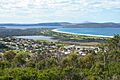
View of Lake Seppings from Mount Clarence.

See also
 In Spanish: Albany (Australia Occidental) para niños
