Hopetoun, Western Australia facts for kids
Quick facts for kids HopetounWestern Australia |
|||||||||||||||
|---|---|---|---|---|---|---|---|---|---|---|---|---|---|---|---|

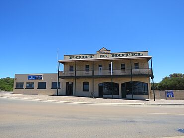
The heritage listed Port Hotel on Veal Street, Hopetoun
|
|||||||||||||||
| Established | 1900 | ||||||||||||||
| Postcode(s) | 6348 | ||||||||||||||
| Elevation | 13 m (43 ft) | ||||||||||||||
| Area | [convert: needs a number] | ||||||||||||||
| Location |
|
||||||||||||||
| LGA(s) | Shire of Ravensthorpe | ||||||||||||||
| State electorate(s) | Roe | ||||||||||||||
| Federal Division(s) | O'Connor | ||||||||||||||
|
|||||||||||||||
|
|||||||||||||||
Hopetoun is a town on the south coast of Western Australia. It is located in the Shire of Ravensthorpe. The town sits on Mary Ann Harbour. Hopetoun is about 590 kilometers (367 miles) southeast of Perth. It is also 160 kilometers (99 miles) west of Esperance.
Contents
A Look Back: Hopetoun's History
How Mary Ann Harbour Got Its Name
In November 1865, a sealer named James Sale explored this area. He was on a small boat called the Mary Ann. This boat belonged to a whaling master, John Thomas. John Thomas had named his boat after his oldest daughter. That's how Mary Ann Harbour got its name!
The Founding of Hopetoun
Hopetoun was officially started in 1900. It was built as a port for the Phillips River goldfield. This meant it was a place where ships could load and unload goods for the gold mines. The town was named after John Hope. He was the very first Governor-General of Australia. The town's location was officially marked on maps in February 1901.
Hopetoun's Role in Mining and Trade
Hopetoun became an important shipping port for the mining industry. A long pier, called a jetty, was built in 1901. This jetty was the end point of a railway line. The train track connected Hopetoun to Ravensthorpe. This railway helped move goods and people from 1909 to 1935. The port eventually closed in 1937. The jetty stayed until it was destroyed in 1983.
Modern Power and Community Life
Today, Hopetoun uses a special system for some of its electricity. It's called a wind-diesel system. This means it uses two large wind turbines. It also has two diesel generators. This mix helps provide power to the town.
In 2016, about 871 people lived in Hopetoun. This number was lower than in 2011. This happened because a nearby mine, the Ravensthorpe Nickel Mine, closed down. Many people who worked at the mine used to live in Hopetoun.
Even with the population change, Hopetoun has important services. It has a primary school and a police station. A doctor visits both Hopetoun and Ravensthorpe. The town also has a hotel, motel, and other shops. These include a bakery, a supermarket, and cafes. There's also a post office, hairdressers, and a community center.
Hopetoun's Climate
Hopetoun has a warm-summer Mediterranean climate. This type of climate means it has warm, fairly dry summers. The winters are mild with some drizzle and rain.
Temperatures and Rainfall
- Warmest Month: February, with average high temperatures around 25.5 degrees Celsius (78 degrees Fahrenheit).
- Coolest Month: July, with average high temperatures around 18.1 degrees Celsius (64 degrees Fahrenheit).
- Rainfall: The town gets about 481.9 millimeters (19 inches) of rain each year. It rains quite often, spread across about 133 days.
- Extreme Temperatures: The hottest day recorded was 48.0 degrees Celsius (118.4 degrees Fahrenheit) in January 2010. The coldest was -1.1 degrees Celsius (30.0 degrees Fahrenheit) in July 2014.
| Climate data for Hopetoun (33°56′S 120°08′E / 33.93°S 120.13°E) (26 m (85 ft) AMSL) (1996-2024 data) | |||||||||||||
|---|---|---|---|---|---|---|---|---|---|---|---|---|---|
| Month | Jan | Feb | Mar | Apr | May | Jun | Jul | Aug | Sep | Oct | Nov | Dec | Year |
| Record high °C (°F) | 48.0 (118.4) |
45.8 (114.4) |
43.9 (111.0) |
38.0 (100.4) |
35.1 (95.2) |
27.6 (81.7) |
26.4 (79.5) |
32.2 (90.0) |
34.8 (94.6) |
39.5 (103.1) |
44.5 (112.1) |
44.6 (112.3) |
48.0 (118.4) |
| Mean daily maximum °C (°F) | 25.1 (77.2) |
25.5 (77.9) |
24.8 (76.6) |
23.3 (73.9) |
21.2 (70.2) |
18.9 (66.0) |
18.1 (64.6) |
18.7 (65.7) |
20.2 (68.4) |
21.3 (70.3) |
23.0 (73.4) |
24.0 (75.2) |
22.0 (71.6) |
| Mean daily minimum °C (°F) | 15.3 (59.5) |
15.8 (60.4) |
14.6 (58.3) |
12.7 (54.9) |
10.5 (50.9) |
8.7 (47.7) |
7.8 (46.0) |
7.9 (46.2) |
8.7 (47.7) |
10.3 (50.5) |
12.3 (54.1) |
14.0 (57.2) |
11.6 (52.8) |
| Record low °C (°F) | 8.2 (46.8) |
7.7 (45.9) |
6.7 (44.1) |
5.0 (41.0) |
1.8 (35.2) |
0.6 (33.1) |
−1.1 (30.0) |
0.6 (33.1) |
1.4 (34.5) |
0.5 (32.9) |
4.9 (40.8) |
5.8 (42.4) |
−1.1 (30.0) |
| Average precipitation mm (inches) | 30.6 (1.20) |
23.0 (0.91) |
30.5 (1.20) |
37.8 (1.49) |
43.9 (1.73) |
53.1 (2.09) |
63.5 (2.50) |
57.0 (2.24) |
48.7 (1.92) |
41.7 (1.64) |
31.7 (1.25) |
21.5 (0.85) |
481.9 (18.97) |
| Average precipitation days (≥ 0.2 mm) | 6.1 | 6.1 | 9.4 | 11.9 | 13.8 | 14.5 | 15.8 | 15.8 | 13.9 | 11.2 | 8.6 | 6.3 | 133.4 |
| Average afternoon relative humidity (%) | 63 | 63 | 62 | 62 | 59 | 56 | 57 | 56 | 56 | 59 | 61 | 60 | 60 |
| Average dew point °C (°F) | 14.4 (57.9) |
14.8 (58.6) |
13.9 (57.0) |
12.7 (54.9) |
10.5 (50.9) |
8.0 (46.4) |
7.3 (45.1) |
7.5 (45.5) |
8.3 (46.9) |
9.5 (49.1) |
11.8 (53.2) |
12.7 (54.9) |
10.9 (51.7) |
| Source: Bureau of Meteorology (1996-2024 data) | |||||||||||||
 | Shirley Ann Jackson |
 | Garett Morgan |
 | J. Ernest Wilkins Jr. |
 | Elijah McCoy |


