
Torbay, Western Australia facts for kids
Quick facts for kids TorbayWestern Australia |
|
|---|---|

Torbay Agricultural Hall, opened 25 July 1912
|
|

Torbay
Location in Western Australia
|
|
| Established | 1889 |
| Postcode(s) | 6330 |
| Elevation | 69 m (226 ft) |
| Area | [convert: needs a number] |
| Location | |
| LGA(s) | Albany |
| State electorate(s) | Albany |
| Federal Division(s) | O'Connor |
Torbay is a small town and a bay in the Great Southern region of Western Australia. It's located about 20 kilometres (12 mi) west of Albany. Torbay is part of the City of Albany area. The town was officially named Torbay in 1910.
The Torbay area is near the edge of the karri forest. You can find some amazing tall forests here. Large granite rocks are also common. The beaches in the bay have very fine white sand. Streams in the area have clear water, but it looks dark brown. This is because of natural colors from plants.
Most kids in Torbay go to schools in Albany. They travel there by school bus. There is also a local private school called Woodbury Boston Primary School.
Contents
Torbay's Past: A Look at History
The name Torbay comes from Tor Bay, a bay on the coast. Captain Matthew Flinders named it in 1801. He named it after Tor Bay in Devon, England. This was the home port of Admiral Richard Howe's fleet. Flinders had worked for Admiral Howe. Admiral Howe was sometimes called "Lord Torbay." Flinders named other places nearby after Lord Howe. This included Torbay (the bay), Torbay Inlet, Torbay Head, and West Cape Howe.
Early explorers visited the Torbay area. These included Matthew Flinders in 1801. Others were Thomas Braidwood Wilson in 1829. John Septimus Roe and Stirling explored in 1835.
Building Ships in Torbay
In November 1835, Roe and Stirling explored Tor Bay. They were looking for places to build ships. From the late 1830s to the 1860s, ships were built here. This industry was at Port Harding (Migo Island). They used timber from the Guarinup Hills. Ships as large as 150 tons were made.
Whaling in Torbay Bay
A station for whaling was set up on the beach. It was behind Migo Island in Tor Bay. Whales were caught here from 1844 to 1846. They also caught whales from 1861 to 1864.
Forestry and Timber Industry
In 1886, a company called C & E Millar started sawmills. These were at Bornholm. They supplied timber for building the Great Southern Railway. At first, timber was shipped out by boat. It went from Port Harding to Albany. Later, a special tramline was built to Elleker.
In 1889, Millars got a large area of land. This was called the Torbay Estate. It was about 22,000 acres. They got this land for extending the railway. They also had to set up sawmills in Torbay. The two Bornholm mills were moved to Torbay. They were made bigger.
Torbay became a busy timber town for about six years. Timber was brought by tramline from far away. By 1895, most of the good timber in Torbay was cut down. The railway was extended again to Denmark in 1896. In 1900, the land was divided up. It was then sold for farming.
Torbay's Railway Services
The railway line from Elleker to Torbay and Denmark closed in 1905. The State then leased the line. WAGR train services started in 1907. In 1908, Millars sold the railway to the government.
The railway line was extended further in 1926. In 1929, the first passenger train went to Nornalup. The train service through Torbay finally closed in 1957. The tracks were removed in 1963.
There were two main railway spots in Torbay.
- Torbay was the main station and siding. It was built in 1889 and closed in 1957.
- Torbay Junction opened in 1897 as Lakeside. It was renamed Torbay Junction in 1908. Later, in 1921, it became known as Elleker.
What Torbay Does Today: Modern Industries
Torbay has several local industries. These include dairy farming and raising beef cattle. There is also plantation forestry. People grow special plants for horticulture. Arts and crafts are also popular. Tourism is important too.
Farmers are supported by local businesses. These include mechanics and places that supply lime. There are also companies for machinery and hiring workers.
A seasonal fishing industry happens in the bay. Fishermen catch herring and Australian salmon. This usually happens from February to April.
Torbay has been known for growing potatoes for over 100 years. It's especially good for growing seed potatoes. While some pumpkins are grown, potatoes are the main crop. Torbay currently produces about half of Western Australia's seed potatoes.
Exploring Tor Bay: The Watery Side
Tor Bay includes Port Harding and Port Hughes. Port Harding was named in 1838. Port Hughes was named in 1831. Torbay Inlet is also part of the bay. These areas are between Torbay Head and Stony Island. Torbay Head is the most southern point on the mainland of Western Australia. It's also the most western point of the Great Australian Bight.
Islands in Tor Bay include Migo Island and Richard Island. Migo Island was named after a local Aboriginal person. Richard Island was named after Admiral Richard Howe. Both were named by Roe in 1835. Shelter Island is also in the bay.
Popular beaches on the bay are Perkins Beach, Muttonbird Beach, and Cosy Corner. You can reach all of them by car. Cosy Corner Beach is very well-known. It's a great family beach with picnic spots and camping. Kids can even have swimming lessons there in the summer. Some other beaches can only be reached by four-wheel drive vehicles.
The Bibbulmun Track walking trail goes around the bay. It comes down long steps from the hills above Cosy Corner. It then follows the beach around the bay. It crosses the mouth of Torbay Inlet along Muttonbird Beach. The track goes near Shelter Island.
Torbay on Mars!
Did you know there's a place named Torbay on the planet Mars? A large impact crater on Mars was named Torbay in 1988. It is about 6.33 kilometres (3.93 mi) wide.
Gallery
-
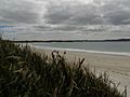
Cosy Corner beach, Torbay
-
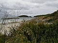
Cosy Corner beach, Torbay
-
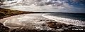
Cosy Corner beach, Torbay


