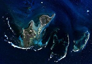
West Wallabi Island facts for kids
| Geography | |
|---|---|
| Location | Indian Ocean, off the coast of Western Australia |
| Coordinates | 28°27′55″S 113°41′41″E / 28.46528°S 113.69472°E |
| Archipelago | Houtman Abrolhos |
| Area | 6.21 km2 (2.40 sq mi) |
| Coastline | 14.93 km (9.277 mi) |
| Administration | |
|
Australia
|
|
| State | Western Australia |
| Demographics | |
| Population | Uninhabited |
West Wallabi Island is a cool island located in the Indian Ocean, off the west coast of Australia. It's part of the Houtman Abrolhos island group, specifically in the Wallabi Group. This island is known for its interesting history and unique wildlife.
Contents
Island History: The Batavia Shipwreck
West Wallabi Island played a big part in the dramatic story of the Batavia shipwreck and a terrible event that happened in 1629. After the ship crashed, a group of soldiers led by Wiebbe Hayes were sent to the island. Their mission was to find fresh water.
Soldiers' Survival and the Mutiny
A group of mutineers, who had taken control of the other survivors, left the soldiers on West Wallabi Island. They hoped the soldiers would starve or die of thirst. But the soldiers were clever! They found they could walk through the shallow water to East Wallabi Island. There, they discovered a fresh water spring.
Even better, West and East Wallabi Islands are the only places in the whole island group where the tammar wallaby lives. This meant the soldiers had both food and water, which the mutineers didn't have.
Australia's Oldest European Structures
Later, the mutineers attacked the soldiers several times, but the soldiers fought them off. The soldiers built strong, simple walls and shelters from stone. These structures are known as the Wiebbe Hayes Stone Fort. They are Australia's oldest known European buildings. They were built more than 150 years before famous explorers like James Cook and Arthur Phillip arrived in Australia.
Because of Wiebbe Hayes's bravery and the fort, East Wallabi Island is sometimes called "Wiebbe Hayes' Island." This name was used a long time ago and by historians.
Island Geography
West Wallabi Island is the biggest island in the Houtman Abrolhos. It covers an area of 6.21 square kilometers (about 2.5 square miles). This is more than a third of all the land in the whole island group!
Island Location and Features
The island is located in the north-west part of the Wallabi Group. This is the northernmost of the three island groups in the Houtman Abrolhos.
West Wallabi Island has three points that have names: Slaughter Point, Blowfish Point, and Pelican Point. Between Blowfish Point and Pelican Point, you'll find a bay called Shag Bay. South of Pelican Point is another bay called Horseyard Bay.
Surrounding Coral Reefs
The island is surrounded by amazing underwater coral reefs. These reefs are narrow at Shag Bay. However, they are very wide along the rest of the coast.
To the north-east, the reef is high enough that you can wade from West Wallabi Island to other islands. These connected islands include Barge Rock, Turnstone Island, Seagull Island, Oystercatcher Island, and East Wallabi Island.
Island Geology: How West Wallabi Island Was Formed
The main rock layer of West Wallabi Island is called the Wallabi Limestone. This is a very hard type of coral limestone. It forms a platform that supports the entire Wallabi Group of islands.
Ancient Reefs and Sea Levels
This rock platform is about 40 meters (130 feet) thick. It formed during a period called the Quaternary era. About 125,000 years ago, during a warm period called the Eemian interglacial, sea levels were higher than they are today.
Reefs that grew during that time are now above the water in some places. These old reefs form the base of the central islands in the group, including West Wallabi Island.
Layers of Rock and Sand
On top of this limestone base, you can find a layer of rock made from ancient sand dunes. This layer is called aeolianite. In some areas, this is then covered by more recent sand dunes.
Island Flora: Plant Life
West Wallabi Island is one of the few islands in the Houtman Abrolhos that has large sand dune systems. This means it has a lot of different kinds of plants. A study in 2001 found 97 different plant species on the island.
Important Plant Communities
Both the sand dunes and the limestone areas have many different plants. These plant groups are mostly made up of chenopod shrubs. These plant communities are very important for protecting different species. This is because they are diverse, but they can also be easily damaged and take a long time to grow back.
Island Birds
West Wallabi Island is part of the Houtman Abrolhos Important Bird Area. This area is recognized by BirdLife International. It's important because many seabirds come here to breed and raise their young.
 | May Edward Chinn |
 | Rebecca Cole |
 | Alexa Canady |
 | Dorothy Lavinia Brown |


