
North Island (Houtman Abrolhos) facts for kids

Aerial photograph of the southern half of North Island, looking west
|
|
 |
|
| Geography | |
|---|---|
| Location | Indian Ocean, off the coast of Western Australia |
| Coordinates | 28°18′9″S 113°35′41″E / 28.30250°S 113.59472°E |
| Archipelago | Houtman Abrolhos |
| Area | 180 ha (440 acres) |
| Length | 2 km (1.2 mi) |
| Width | 1.5 km (0.93 mi) |
| Highest elevation | 13 m (43 ft) |
| Highest point | Record Hill |
| Administration | |
|
Australia
|
|
| State | Western Australia |
| Demographics | |
| Population | Seasonally inhabited by about 130 lobster fishers (2003) |

North Island is the most northern island in the Houtman Abrolhos. This is a group of coral reef islands in the Indian Ocean. It is off the coast of Western Australia. North Island is about 14 km (9 mi) from the next closest island group. It is one of the biggest islands in the Houtman Abrolhos. It is also one of the few islands with sand dunes. The island has many different plants, mostly shrubs. It also has animals like the tammar wallaby, several types of reptiles, and about 15 kinds of birds.
People first explored North Island in 1840. Since the early 1900s, it has been a seasonal home for western rock lobster fishermen. Fishing is still the main activity here. A few tourists visit the island. However, most of the island is a nature reserve. This helps protect its plants and rare birds.
Contents
History of North Island
Early Discoveries
The first time North Island was officially seen was in May 1840. This happened during a survey trip by the ship HMS Beagle. The ship's commander, John Clements Wickham, saw the island from Flag Hill on East Wallabi Island. His crew explored North Island on May 22. They named it "North Island" because it was the most northern island in the Abrolhos. Before leaving, Wickham left a letter in a bottle on the island's highest hill. He named this hill Record Hill.
The first map showing North Island was made in 1845. It was a British map called "The Houtman Rocks". The next year, Wickham's officer, John Lort Stokes, wrote about the island. He said:
"The island was about a mile across, and nearly circular. It was surrounded by a range of hills, with a flat in the centre, covered with coarse grass, where a great many quails were flushed, affording good sport, but not a single wallaby."
Fishing and Buildings
Fishermen started catching western rock lobsters around North Island in the early 1900s. Records show the island was used by crayfishers as early as 1902. For many years, it was a place for anglers to anchor their boats.
A permanent camp for fishermen was set up in 1947. It was used only during the fishing season. According to a former crayfisher, Ron Bertelsen, the first camp was built by skippers George Barker and George Nelson and deckhand John Long. They moved there when lobsters became hard to find near Pigeon Island. Their first camp was at the southern end of North Island. It was made from old packing cases. A local boat, the Betty Margaret, brought supplies to the camp. In 1940, about 40 people lived on the island during the season. By 2003, this number grew to about 130. An airstrip was built on the island in 1979.
Visiting Scientists
Many scientists have visited North Island over the years. The first group was the Percy Sladen Trust Expedition in 1913. They didn't spend much time on North Island. Other islands seemed better for their studies. But they still wrote important information about the island. This included what the land looked like and a list of its animals with backbones.
An Australian bird expert, Dom Serventy, visited in 1945. In 1959, a group from the University of Western Australia came with a botanist named Mary Gillham. They wrote a short article about the island's land, plants, and animals. More recently, other scientists have visited the island.
Island Geography

North Island is located at 28°18′9″S 113°35′41″E / 28.30250°S 113.59472°E. It is a lonely island, far from its closest neighbors. It is separated from the Wallabi Group by the 14 km (9 mi) wide South Passage. Even though it's separate, it's sometimes considered part of the Wallabi Group. The island is shaped like a diamond. It is about 2 km (1+1⁄4 mi) long from south to north. It is about 1+1⁄2 km (1 mi) wide from west to east. This gives it an area of about 180 hectares (450 ac).
Two high points on the island are named Record Hill and Latitude Hill. These are the only official place names on the island. However, some other spots have unofficial names. For example, the northernmost point is called "North Point." The southernmost point is called "South Point."
On the eastern side of the island, there is a camp for fishermen. It is used during the fishing season. There is also a lighthouse on the western side. A trig point (a survey marker) is on the eastern side. A gravel airstrip is near the center of the island.
.svg)
A coral reef flat surrounds the island. This reef stretches about 1+1⁄2 km (1 mi) to the west. It goes over 3 km (2 mi) to the north and south. But on the eastern side, the reef is quite close to the island. Most of the reef is too shallow for boats. However, there are passages through the reef. One is just north of the island, called Suda Bay Passage. Another is just south, called Barker Passage. There are also a few breaks on the eastern side where boats can find shelter. An area of reef north of the island is called The Flat. At the very northern end of the reef is a large wave called The Big Breaker. About 200 m (660 ft) west of the island is a small rock. It is unofficially known as "Shag Rock."
North Island is part of Australia. It is in Western Australia. It is also part of the Houtman Abrolhos Nature Reserve. This is a special "A-class" nature reserve. It is managed by Western Australia's Department of Fisheries. This department works to protect the island's nature.
Geology and Landforms
North Island sits on a base of Wallabi Limestone. This is a strong, coral limestone platform. It is found under all the islands in the Wallabi Group. This platform rises sharply from a flat shelf. It is about 40 m (131 ft) thick. It formed during the Quaternary period. Some parts of the reef formed about 125,000 years ago. At that time, sea levels were higher. These old reef parts now stick out of the water. They form the base of islands like West Wallabi, East Wallabi, and North Island.
Most of North Island's base is not very high, usually less than 1.5 m (4 ft 11 in). Much of it is covered by aeolianite (wind-blown rock) and sand. But some parts of the rock base are visible. For example, the southern edge of the island has a low cliff. The sea has worn away much of this cliff.
There are large sand dunes on both the western and eastern sides of the island. These dunes are made of loose sand from the Holocene period. The shape of these dunes changes over time. In 1913, the eastern dunes were much higher than the western ones. But in 1960, the eastern dunes were badly worn away. This was probably because a fire burned much of the island's plants in 1935. In the middle of the island, there is a low, flat area. It has a sinkhole in its southwest corner. There is also a small salt lake near its northern edge. The soil in the center of this flat area is shallow loam. The edges have deeper soil, mostly made of shell pieces.
Weather on the Island
Since 1990, an automatic weather station has been on North Island. It records hourly measurements of rain, air temperature, wind speed, wind direction, relative humidity, and atmospheric pressure. This is the only weather station in the Houtman Abrolhos. So, its information helps us understand the weather for all the islands.
Based on this data, the Houtman Abrolhos has a Semi-arid climate. This means it has warm, dry summers and cooler, wet winters. Average temperatures in July range from 9.3 to 19.5 °C (49 to 67 °F). In February, they range from 19.1 to 32.4 °C (66 to 90 °F). This temperature range is smaller than on the mainland. Summers are usually a degree cooler, and winters are much warmer. This is because the ocean, especially the Leeuwin Current, affects the island's temperature.
Most of the island's rain (86%) falls between April and September. On average, it rains 89 days a year, with 469 mm (18 in) of rain. June is the wettest month, usually getting over 100 mm (4 in) of rain. In contrast, only about 70 mm (3 in) of rain falls between October and March.
It is almost always windy on North Island. In summer, strong winds usually blow from the southeast or southwest. They blow at speeds over 17 kn (31 km/h) almost half the time. In autumn and winter, the winds change. Winter can bring the strongest gales and also the calmest periods. There is also a daily wind pattern. In the morning, land breezes blow. In the afternoon, south-westerly sea breezes start. This happens because of temperature differences between the land and the ocean.
Three types of storms happen in this area. Short, strong squalls can occur from December to April. A tropical cyclone hits the area about once every three years, between January and April. These storms can bring very strong, damaging winds. In winter, extra-tropical cyclones sometimes pass south of Geraldton. These cause winter gales with wind gusts up to 35 m/s (115 ft/s). The wind direction starts from the northwest and slowly moves to the south.
| Climate data for North Island | |||||||||||||
|---|---|---|---|---|---|---|---|---|---|---|---|---|---|
| Month | Jan | Feb | Mar | Apr | May | Jun | Jul | Aug | Sep | Oct | Nov | Dec | Year |
| Record high °C (°F) | 36.8 (98.2) |
38.9 (102.0) |
39.1 (102.4) |
34.5 (94.1) |
29.4 (84.9) |
27.1 (80.8) |
25.6 (78.1) |
27.2 (81.0) |
31.1 (88.0) |
33.4 (92.1) |
34.0 (93.2) |
36.0 (96.8) |
39.1 (102.4) |
| Mean daily maximum °C (°F) | 27.6 (81.7) |
28.5 (83.3) |
28.2 (82.8) |
26.3 (79.3) |
24.3 (75.7) |
22.3 (72.1) |
21.1 (70.0) |
21.7 (71.1) |
22.2 (72.0) |
23.5 (74.3) |
25.4 (77.7) |
26.6 (79.9) |
24.8 (76.6) |
| Mean daily minimum °C (°F) | 21.4 (70.5) |
22.0 (71.6) |
21.9 (71.4) |
20.4 (68.7) |
18.5 (65.3) |
16.6 (61.9) |
15.3 (59.5) |
15.5 (59.9) |
16.0 (60.8) |
17.2 (63.0) |
18.6 (65.5) |
20.0 (68.0) |
18.6 (65.5) |
| Record low °C (°F) | 15.7 (60.3) |
17.9 (64.2) |
15.4 (59.7) |
13.9 (57.0) |
10.1 (50.2) |
7.1 (44.8) |
6.2 (43.2) |
6.8 (44.2) |
8.3 (46.9) |
10.4 (50.7) |
11.5 (52.7) |
15.1 (59.2) |
6.2 (43.2) |
| Average precipitation mm (inches) | 2.8 (0.11) |
3.1 (0.12) |
7.1 (0.28) |
18.3 (0.72) |
48.9 (1.93) |
60.9 (2.40) |
70.7 (2.78) |
35.3 (1.39) |
21.9 (0.86) |
6.9 (0.27) |
7.3 (0.29) |
3.6 (0.14) |
286.0 (11.26) |
| Average precipitation days | 1.3 | 1.2 | 2.3 | 4.0 | 9.3 | 10.8 | 13.6 | 10.4 | 9.0 | 3.5 | 2.9 | 1.3 | 69.6 |
| Source: Bureau of Meteorology | |||||||||||||
Plants of North Island
Most of North Island is covered by chenopod shrubs. These plants are usually less than a meter (3 ft) tall. Near the beach, you'll find plants like Spinifex longifolius (beach spinifex) and Salsola kali (prickly saltwort). There are also Atriplex cinerea (grey saltbush) and Cakile maritima (sea rocket), which is not native.
Stable sand dunes have plants like Atriplex paludosa (marsh saltbush) and Scaevola crassifolia (thick-leaved fan-flower). You can also see Olearia axillaris (coastal daisy-bush) and Myoporum insulare (blueberry tree). The Exocarpos sparteus (broom ballart) also grows here. In sheltered areas behind the dunes, you'll find Salsola kali and Myoporum insulare. The Nitraria billardierei (nitre bush) is the only plant on the island that grows taller than 1+1⁄2 m (5 ft). Where the limestone is close to the surface, plants like Pimelea microcephala (shrubby rice-flower) and Spyridium globulosum (basket bush) grow.
The edge of the central flat area has many dense shrubs. These include Rhagodia baccata (berry saltbush) and Atriplex paludosa. Closer to the center, the plants are Frankenia pauciflora (seaheath) and Muellerolimon salicorniaceum. Also, Tecticornia arbuscula (bulli bulli) grows here. However, T. arbuscula is replaced by Tecticornia halocnemoides (shrubby samphire) where the soil is shallow. The lowest part of the central plain gets very wet in winter. It is covered by a thick mat of Sarcocornia quinqueflora (beaded samphire), Sporobolus virginicus (marine couch), and Suaeda australis (seablite).
The plants on the dunes, limestone, and around the salt lake are very important to protect. The dune and limestone plants have many different species. They are easily harmed and grow back slowly. The salt lake plants are special because salt lakes are rare on islands.
Animals of North Island
Mammals on the Island

No land mammals are originally from North Island. But Australian sea lions sometimes rest on the island's beaches. Some people think that tammar wallabys (Macropus eugenii) used to live here naturally.
In 1840, Stokes said there were no tammar wallabies on North Island. Scientists in 1913 also didn't find any. But it seems wallabies were brought to the island in the 1920s. Early fishermen reported seeing them between 1928 and 1930. This attempt failed, possibly because there wasn't enough food. No wallabies were found in 1945 or 1959. However, many wallaby bones were found in 1959. This suggests a native population might have died out before 1840. But later scientists don't agree with this idea.

In 1985, five tammar wallabies were brought to North Island. This time, the population grew successfully. This might be because there are no carpet pythons (their natural predators) on the island. Also, the wallabies might get extra food and water from the fishermen's huts. These huts are used during the toughest time of the year. The airstrip also seems to provide extra food for them. By the 2000s, there were over 450 tammar wallabies on the island. The wallabies ate too many native plants. This reduced plant cover and caused some plant species to decline. In 2003, island residents asked for help. They wanted to control the wallaby population. By February 2008, the wallaby population was reduced to about 25 individuals.
The only other mammal found on the island is the house mouse. It is not native. Eight European rabbits were brought in 1934. By 1945, there were "exceedingly numerous" rabbits. But by 1960, they were gone. This was probably because feral cats ate them. Now, neither rabbits nor cats are found on the island.
Reptiles on the Island
Reptiles found on North Island include:
- Binoe's prickly gecko (Heteronotia binoei)
- The gecko Christinus marmoratus
- The Jew lizard (Pogona barbata)
- King's skink (Egernia kingii)
- The western limestone ctenotus (Ctenotus australis)
- The western worm lerista (Lerista praepedita)
- The common dwarf skink (Menetia greyii)
- The Abrolhos bearded dragon (Pogona minor minima)
The carpet python was reported to be on the island in small numbers before 1960. But scientists have never seen it there. It is now gone from the island.
Many green turtles (Chelonia mydas) have been seen near the shore. Some people say they lay their eggs on the island. If this is true, North Island would be the most southern place in Western Australia where they breed.
Birds of North Island
Two important birds on North Island are the Abrolhos painted buttonquail (Turnix varius scintillans) and the brush bronzewing (Phaps elegans). The Abrolhos painted buttonquail is a rare type of buttonquail. It is only found in the Wallabi Group and is protected by law. The brush bronzewing is very common on North Island. However, its numbers are decreasing on the mainland.
Other birds that breed on North Island include:
- The osprey (Pandion haliaetus cristatus)
- The greater crested tern (Thalasseus bergii)
- The Caspian tern (Hydroprogne caspia)
- The silver gull (Chroicocephalus novaehollandiae novaehollandiae)
- The welcome swallow (Hirunda neoxena)
Birds that live on the island but are not recorded breeding there include:
- The Pacific reef heron (Egretta sacra)
- The white-bellied sea eagle (Haliaeetus leucogaster)
- The red-capped plover (Charadrius ruficapillus)
- The fairy tern (Sterna nereis nereis)
- The Australasian pipit (Antus novaseelandiae australis)
- The western silvereye (Zosterops lateralis chloronotus)
The sooty oystercatcher (Haematopus fuliginosus fuliginosus) and white-backed swallow (Cheramoeca leucosterna) are sometimes seen on the island.
Many birds visit the island. The most common visitors are:
- The bar-tailed godwit (Limosa lapponica baueri)
- The grey-tailed tattler (Tringa brevipes)
- The ruddy turnstone (Arenaria interpres interpres)
- The red-necked stint (Calidris ruficollis)
- The curlew sandpiper (Calidris ferruginea)
North Island is part of the Houtman Abrolhos Important Bird Area. This area is important because it supports many breeding seabirds.
How People Use the Island
The entire Houtman Abrolhos is a protected nature reserve. It is managed by Western Australia's Minister for Fisheries. The goals are to protect plants and animals, allow tourism, and support the fishing industry.
Fishing Life
North Island is mainly used as a seasonal camp for Western Rock Lobster fishermen. During lobster season, from March 15 to June 30, about 130 fishermen live at the camp. A boat called the North Islander visits the island every three days. It brings supplies and takes away the lobsters and any trash.
Protecting Nature
North Island is very important for nature. It has special populations of brush bronzewings and Abrolhos painted buttonquails. Its sand dune, limestone, and salt lake plant communities are also very valuable. Scientists have not yet checked for old items on Record Hill. These could include the bottle left by Wickham and Stokes in 1840.
An area of reef south of North Island, about 514 ha (1,270 acres), is a Reef Observation Area (ROA). Fishing is not allowed here, except for lobster pots. This protected area helps save fish species that are caught elsewhere. It also gives divers a chance to see large groups of fish that are not afraid of people.
Island Tourism
North Island has wide sand beaches, bird breeding areas, and good dive sites in the Reef Observation Area. This makes it an attractive place for tourists. However, all the limited boat anchor spots and jetties are used by commercial fishermen. So, if you want to land a private or charter boat, you need to arrange it beforehand. Also, visitors are not allowed to camp on the island.
North Island gets about 3.5% of private boat trips to the Houtman Abrolhos. It gets about 1% of commercial charter boat trips. The latest tourism plan for the Houtman Abrolhos supports charter boats using North Island. It also supports using the airstrip for tourism. But it does not recommend building a land-based tourist site there.
Images for kids
-
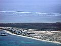
Aerial photograph of the southern half of North Island, looking west
-
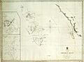
The first published map showing North Island was an 1845 British Admiralty chart entitled "The Houtman Rocks".
-
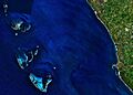
A view from space of the Houtman Abrolhos and adjacent Western Australian coast; North Island is in the top left corner.
-
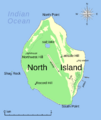
A map of North Island. See text for details.
-
A tammar wallaby on North Island
-
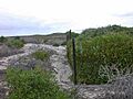
Much of North Island has been heavily overgrazed by tammar wallabies. Note the difference in vegetation density either side of the fence line.
