
Cape Leeuwin facts for kids
Quick facts for kids Cape LeeuwinWestern Australia |
|
|---|---|

Cape Leeuwin and the Cape Leeuwin Lighthouse as seen from the north
|
|

Cape Leeuwin
Location in Western Australia
|
Cape Leeuwin is a famous spot in Western Australia. It's the most south-westerly point of the Australian mainland. Imagine standing right where two huge oceans meet! Many people in Australia believe this is where the Indian Ocean and the Southern Ocean come together.
Near the cape, you'll find the tall Cape Leeuwin Lighthouse. This lighthouse has guided ships for many years. There are also small islands and rocks nearby called the St Alouarn Islands. The closest town to Cape Leeuwin is Augusta, which is just north of the cape.
Contents
What's in a Name?
Cape Leeuwin is often talked about with another nearby headland, Cape Naturaliste. Together, they help describe the land and nature of the area. For example, there's a big park called the Leeuwin-Naturaliste National Park. You might also hear people talk about the "Cape to Cape" region when they mean this special area.
Even the Royal Australian Navy has named a ship and a base after Cape Leeuwin. They called them HMAS Leeuwin.
A Look Back in Time
The first people to live in this area were the Wardandi Aboriginals. They had their own name for this place: "Doogalup."
The name "Cape Leeuwin" comes from an old Dutch ship called the Leeuwin (which means "Lioness"). This ship explored parts of the coastline way back in 1622. We don't have the ship's logbook anymore, so we don't know much about its journey. However, the land it found was put on a map in 1627. This map showed the coast between what is now Hamelin Bay and Point D’Entrecasteaux.
Other European ships sailed past the cape over the next 200 years. These included the Dutch ship t Gulden Zeepaert in 1627 and the French ship Gros Ventre in 1772.
The first European to actually see the cape was Bruni d'Entrecasteaux in 1791. He thought it was an island and named it "Isle St Allouarn." Ten years later, in 1801, the English explorer Matthew Flinders began mapping the south coast of New Holland (which is what Australia was called then). Flinders was the one who named it "Cape Leeuwin." He knew the Dutch had called the area "Leeuwin's Land."
Flinders landed in the bay just east of Cape Leeuwin, which is now called Flinders Bay. He wrote that he first thought the cape was an island, but then realised it was connected to the mainland. He called it "Cape Leeuwin" because it was the most south-western part of "Leeuwin's Land."
The St Alouarn Islands are a group of small islands located just off the tip of Cape Leeuwin.
Weather at the Cape
The weather at Cape Leeuwin can change a lot. It has warm summers and mild, wet winters. Here's a quick look at the climate:
| Climate data for Cape Leeuwin | |||||||||||||
|---|---|---|---|---|---|---|---|---|---|---|---|---|---|
| Month | Jan | Feb | Mar | Apr | May | Jun | Jul | Aug | Sep | Oct | Nov | Dec | Year |
| Record high °C (°F) | 41.0 (105.8) |
42.8 (109.0) |
39.9 (103.8) |
35.0 (95.0) |
29.3 (84.7) |
24.5 (76.1) |
22.5 (72.5) |
24.0 (75.2) |
27.8 (82.0) |
31.8 (89.2) |
36.1 (97.0) |
38.4 (101.1) |
42.8 (109.0) |
| Mean daily maximum °C (°F) | 23.1 (73.6) |
23.4 (74.1) |
22.7 (72.9) |
21.3 (70.3) |
19.2 (66.6) |
17.4 (63.3) |
16.4 (61.5) |
16.4 (61.5) |
17.1 (62.8) |
18.2 (64.8) |
20.1 (68.2) |
21.8 (71.2) |
19.8 (67.6) |
| Mean daily minimum °C (°F) | 17.0 (62.6) |
17.3 (63.1) |
16.7 (62.1) |
15.5 (59.9) |
13.7 (56.7) |
12.2 (54.0) |
11.3 (52.3) |
11.2 (52.2) |
11.8 (53.2) |
12.6 (54.7) |
14.2 (57.6) |
15.8 (60.4) |
14.1 (57.4) |
| Record low °C (°F) | 9.4 (48.9) |
10.0 (50.0) |
8.0 (46.4) |
7.2 (45.0) |
5.3 (41.5) |
3.3 (37.9) |
4.4 (39.9) |
5.0 (41.0) |
4.2 (39.6) |
4.3 (39.7) |
5.8 (42.4) |
9.4 (48.9) |
3.3 (37.9) |
| Average precipitation mm (inches) | 16.1 (0.63) |
15.7 (0.62) |
27.9 (1.10) |
59.7 (2.35) |
138.7 (5.46) |
176.1 (6.93) |
181.4 (7.14) |
135.8 (5.35) |
91.3 (3.59) |
64.6 (2.54) |
37.1 (1.46) |
20.8 (0.82) |
965.8 (38.02) |
| Average precipitation days | 6.0 | 5.9 | 8.8 | 13.2 | 19.7 | 22.2 | 24.6 | 23.3 | 20.2 | 16.8 | 11.2 | 8.1 | 180.0 |
| Average relative humidity (%) | 72 | 74 | 74 | 75 | 76 | 77 | 77 | 75 | 75 | 75 | 74 | 73 | 75 |
Leeuwin-Naturaliste National Park
The land around the Cape Leeuwin Lighthouse is part of the Leeuwin-Naturaliste National Park. This park is full of unique plants and thick bushes. Many different kinds of birds live here, making it a great place for nature lovers.
The bay just east of Cape Leeuwin is called Flinders Bay. It was named after Matthew Flinders, the explorer who sailed around Australia in the early 1800s.
Shipwrecks Nearby
The waters around Cape Leeuwin have seen some shipwrecks. One famous one is the SS Pericles. This large iron steamship was built in Belfast, Northern Ireland. In 1910, it sank after hitting a rock that wasn't even on the maps! This happened on a clear, calm day.
The wreck of the Pericles was found in 1957 by a diver named Tom Snider. He explored the wreck to get back some lead that the ship was carrying.
Cape Leeuwin in Stories
Cape Leeuwin is even mentioned in a poem! It's part of the children's story The Sing-Song of Old Man Kangaroo by Rudyard Kipling. The poem also helps people learn how to say "Leeuwin" correctly – it rhymes with "flew in."
Images for kids
-
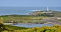
The Cape Leeuwin area, showing the lighthouse, cottages, and surrounding landscape.
-
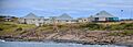
The cottages where lighthouse keepers used to live, seen from the east.
-
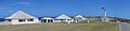
A view of the lighthouse and its cottages at Cape Leeuwin.

See also
 In Spanish: Cabo Leeuwin para niños
