
Macquarie River facts for kids
Quick facts for kids Macquarie River |
|
|---|---|

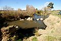
Macquarie River at Bathurst
|
|
| Country | Australia |
| Physical characteristics | |
| River mouth | Barwon River |
| Length | 626 km |


The Macquarie River is a major inland river in New South Wales, Australia. It starts in the central highlands near the town of Oberon. The river flows towards the northwest, passing through towns like Bathurst, Wellington, Dubbo, Narromine, and Warren.
Eventually, the Macquarie River reaches the Macquarie Marshes. These marshes then drain into the lower Barwon River, which is part of the larger Darling River system.
Burrendong Dam is a big dam located near Wellington. It holds water from the Macquarie River and its smaller rivers, called tributaries, like the Cudgegong River and the Turon River. The dam helps stop floods and provides water for irrigation, which means watering crops. This dam created Lake Burrendong.
Contents
River Journey and Geography
The Macquarie River flows for about 626 kilometres (389 miles). From its start to its end, it drops about 517 metres (1,696 feet) in height. Lake Burrendong is the only large dam directly on the river.
Rivers Joining the Macquarie
Six main rivers flow into the Macquarie River:
- Fish River (starts at 670m elevation)
- Turon River (starts at 406m elevation)
- Cudgegong River (starts at 342m elevation)
- Bell River (starts at 285m elevation)
- Little River (starts at 271m elevation)
- Talbragar River (starts at 257m elevation)
There are also 19 smaller creeks that join the Macquarie River. These creeks include:
- Winburndale Rivulet (484m)
- Tambaroora Creek (398m)
- Pyramul Creek (360m)
- Curragurra Creek (351m)
- Triamble Creek (342m)
- Wuuluman Creek (302m)
- Wambangalong Creek (265m)
- Cumboogle Creek (263m)
- Mogriguy Creek (257m)
- Whylandra Creek (255m)
- Coolbaggie Creek (246m)
- Brummagen Creek (239m)
- Gin Gin Creek (217m)
- Greenhide Creek (209m)
- Bulla Bulla Creek (202m)
- Five Mile Cowal (187m)
- Marebone Break (184m)
- Bulgeraga Creek (179m)
- Oxley Break (171m)
Towns Along the River
Several towns are located along the Macquarie River:
- Bathurst
- Wellington
- Dubbo
- Narromine
- Warren
Bridges Crossing the River
Many bridges cross the Macquarie River, including:
- Old Rail Bridge - Bathurst (no longer used)
- New Rail Bridge - Bathurst
- Evans Bridge - Bathurst
- Denison Bridge - Bathurst (built in 1869-1870)
- Rawsonville Bridge - Dubbo (a timber bridge, completed in 1916)
- Scabbing Flat Bridge (a timber bridge, completed in 1911)
- Dundullimal Rail Bridge
The Macquarie River's Catchment Area
The Macquarie River system drains a huge area, covering more than 74,000 square kilometres. Most of this land (over 72%) is flat, while 17% is hilly. The rest is steep or mountainous, reaching up to 900 metres (2,953 feet) high.
The eastern edge of this area is formed by the Great Dividing Range. This mountain range stretches from near Oberon in the south to Coolah in the north.
As the river flows from Bathurst, it passes through different types of land:
- Bathurst Plains: This area is gently rolling country, about 700 metres (2,297 feet) above sea level. It's surrounded by high flat lands and includes a large flat area around Bathurst.
- Hill End Plateau: Here, the Turon River joins the Macquarie from the east. The Turon River drains a plateau that goes from near Portland to Sofala. This area is mostly rugged mountains.
- Burrendong Dam Area: The Cudgegong River joins the Macquarie here. This river starts in the hills around Rylstone.
- Wellington and Dubbo: Between these towns, the Bell and Little Rivers join the Macquarie. The Bell River starts in the flat to rolling country of the Orange plateau. The highest point nearby is Mount Canobolas, an extinct volcano that is 1,400 metres (4,593 feet) above sea level.
- North of Dubbo: The Talbragar River, an important river downstream, joins the Macquarie here. The Talbragar starts in the mountains where the Great Dividing Range meets the Warrumbungle Range.
- Flat Plains: North of Dubbo, the river flows through flat plains towards Narromine and Warren. In this area, many creeks connect the Macquarie, Darling, and Bogan Rivers.
- Macquarie Marshes: These marshes are at the very end of the main river channel. Near Carinda, the Marthaguy Creek joins the Macquarie. This creek carries floodwater from the Macquarie and Castlereagh Rivers.
The amount of rainfall changes across the Macquarie River area. Mountains and high flat lands get more rain because of the surrounding ranges. The Great Dividing Range area receives between 750 to 900 millimetres (30 to 35 inches) of rain each year, spread out evenly. Further northwest, it gets drier, with only 300 to 400 millimetres (12 to 16 inches) of rain annually in some parts.
Rainfall can change a lot from year to year. Sometimes, it can be twice the average, and other times, less than half. Evaporation also varies, from less than 1000 millimetres (39 inches) near Bathurst to over 2000 millimetres (79 inches) at Bourke.
River Facts and Figures
| Total Area | 12,300 km² |
| Total Water Storage | 1,559,620 ML |
| Total Surface Water Used | 406,840 ML/yr |
| Development Category | over developed |
| Average Yearly Run-off | 0 ML/yr |
Aboriginal History of the River
The Wiradjuri people are the original inhabitants of the Macquarie River area. They called the river Wambool. A famous Wiradjuri warrior named Windradyne came from the upper Macquarie River region. He died in a tribal battle near the river in 1829.
Near Carinda, between the Macquarie River and Marra Creek, scientists found the oldest evidence of bread making in the world. This discovery, about 30,000 years old, was made at an ancient lake called Cuddie Springs.
European Exploration and Naming
Europeans first saw the upper parts of the Macquarie River in 1813. The river was named after Lachlan Macquarie, who was the Governor of New South Wales at the time. In 1813, a surveyor named George Evans wrote in his diary:
Tuesday, 30th November 1813. I have at length reached the Ridge I so much wished to do after walking about 2 Miles, where I had a prospect to the North for a great distance; A Mist arises from a part I suppose to be a River or a large Lagoon about 20 Miles Off;
Thursday, 9th December 1813. I have called the Main Stream "Macquarie River".
Later, in 1817-18, John Oxley explored the Lachlan and Macquarie Rivers. In 1828, Charles Sturt proved that the Macquarie River ended in marshes. He also discovered the Darling River.
Water for Farming (Irrigation)
The Macquarie River area is a controlled Water Management Area. This means that water use is managed carefully. It includes private farms that use irrigation, as well as several public irrigation projects. These projects help provide water to farms for growing crops.
Some of these irrigation schemes are:
- Narromine - Trangie
- Buddha Lakes
- Tenandra
- Trangie – Nevertire
- Nevertire
- Marthaguy
Flooding of the Macquarie River

The Macquarie River has a history of flooding. When there are very big floods, water can flow past the Macquarie Marshes and into the Barwon-Darling river system, upstream of Brewarrina.
Major Floods Recorded
- 1867: Floods washed away the first Denison Bridge in Bathurst.
- 1955: There was serious flooding of the Macquarie River and other river systems.
- 1998: A large flood affected the farming of cotton and vegetables.
- 2010: In November and December, there was major flooding of the lower Macquarie River after very heavy rainfall across Eastern Australia.
Fun Activities on the River
Many fun activities happen along the Macquarie River, especially in the towns it passes through.
- Fishing: You can catch many types of freshwater fish here, including brown trout, carp, catfish, golden perch, murray cod, rainbow trout, redfin, silver perch, trout cod, and yabbies.
- Lake Burrendong: This large dam is very popular for water sports. People enjoy skiing, jet skiing, sailing, and general boating.
- Parks: In Bathurst, Bi-Centennial Park is located along the river bank. It's a great place for picnics, events, and bicycle riding.
Images for kids
-
The Macquarie River, not far from its source, near Bathurst

See also
 In Spanish: Río Macquarie para niños
