Warrumbungles facts for kids
Quick facts for kids Warrumbungles |
|
|---|---|

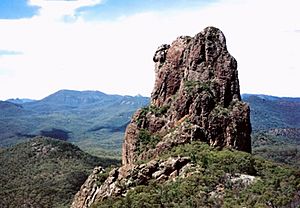
Completing a circuit around the jagged Breadknife is a steep hike taking about five hours.
|
|
| Highest point | |
| Peak | Mount Exmouth |
| Elevation | 1,206 m (3,957 ft) |
| Geography | |
| Country | Australia |
| State | New South Wales |
| Range coordinates | 31°12′S 148°54′E / 31.200°S 148.900°E |
| Geology | |
| Formed by | Shield volcano |
| Age of rock | Cenozoic |
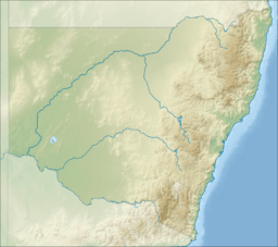
The Warrumbungles is a cool mountain range in the Orana region of New South Wales, Australia. The closest town is Coonabarabran. You can easily get there from the Newell Highway. This highway is a main road that connects Melbourne, Victoria to Brisbane, Queensland. It goes right through the middle of New South Wales.
The Warrumbungles are located between the wet eastern coast and the dry western plains. This means they are a special home for many different plants and animals. Over 120 types of birds live here. These include colourful lories and lorikeets, rosellas, and parrots. The middle of the range is also a safe place for a large group of grey kangaroos. These kangaroos are used to people and are often easy to see up close.
The Siding Spring Observatory is a big telescope located on Mount Woorut, one of the eastern peaks. This area is perfect for looking at stars because there is very little light pollution. Light pollution is when city lights make it hard to see the night sky. In 2016, the International Dark-Sky Association named the Warrumbungle National Park as Australia's first International Dark Sky Park. This means it's one of the best places in the world to see the stars!
The Warrumbungles also hosted the 2006 World Rogaining Championships. Rogaining is a fun sport where teams use maps and compasses to find checkpoints over a large area.
Contents
How the Warrumbungles Were Formed
The very bottom of this region was created about 180 million years ago. Back then, a huge lake formed. Over time, mud and sand settled at the bottom of this lake. This slowly pressed together to form sandstone.
The Warrumbungles you see today are what's left of a giant shield volcano. A shield volcano is a type of volcano that looks like a warrior's shield lying on the ground. It has gentle slopes because its lava flows easily. This volcano was active between 13 and 17 million years ago. Scientists think it was once about 1,000 metres (3,280 feet) tall and 50 kilometres (31 miles) wide! It grew from many volcanic eruptions over millions of years. What we see now are the tough, rocky parts that were left behind after millions of years of wind and rain wore away the softer rock.
Amazing Rock Formations
The main parts of the Warrumbungle mountains are huge, jagged rock shapes. They are arranged in a rough circle. Around them are hills covered in bushes and forests. You'll see many dykes, volcanic plugs, and volcanic domes here. These are all made from a type of rock called trachyte.
The "Grand High Tops" is a special area where many of these volcanic rocks are grouped together. These rocky peaks and vents all have names. Some famous ones include Belougery Spire, Belougery Split Rock, Crater Bluff, Bluff Mountain, The Breadknife, and Mount Exmouth. The Breadknife is especially unique. It's a straight wall of jagged rock almost 100 metres (328 feet) high!
There are nine main walking tracks that let you explore these central peaks. Towards the southeast, you can find more basalt rock formations that stretch towards the Liverpool Range.
History of the Warrumbungles
The first European person to see and explore this area was John Oxley. He did this in 1818 during his second trip through New South Wales. Oxley called the range the Arbuthnot Range. But the local Gamilaroi people had a name for it: Warrumbungles. This name means 'crooked mountains', and it's the name that stuck.
People started climbing these tough peaks a long time ago. Belougery Spire was first climbed by Eric Dark and Osmar White in 1932. Crater Bluff was climbed by Eric Dark and Dorothy English in 1936. The famous Breadknife was not climbed until 1954, by Russ Kippax and Bill Peascod. Today, climbing on the Breadknife is not allowed. This is to protect the walking path below it from falling rocks.
Lieben, a climb on Crater Bluff, was known as the hardest rock climb in Australia for many years. It was first climbed by Bryden Allen and Ted Batty in 1962.
By 1953, a part of the range, about 3,360 hectares (8,300 acres), was set aside to protect its natural beauty. This became the Warrumbungle National Park. In 2011, the national park had grown to cover about 23,311 hectares (57,600 acres).
See also
 In Spanish: Warrumbungles para niños
 | William L. Dawson |
 | W. E. B. Du Bois |
 | Harry Belafonte |


