
Coonabarabran facts for kids
Quick facts for kids CoonabarabranNew South Wales |
|||||||||
|---|---|---|---|---|---|---|---|---|---|

Town centre/ Imperial Hotel
|
|||||||||

Coonabarabran
Location in New South Wales
|
|||||||||
| Population | 2,387 (2021 census) | ||||||||
| Postcode(s) | 2357 | ||||||||
| Elevation | 505 m (1,657 ft) | ||||||||
| Location | |||||||||
| LGA(s) | Warrumbungle Shire | ||||||||
| County | Gowen | ||||||||
| State electorate(s) | Barwon | ||||||||
| Federal Division(s) | Parkes | ||||||||
|
|||||||||
Coonabarabran (/kuːnəbærəbrən/) is a town in Warrumbungle Shire, New South Wales, Australia. It sits between the Central West and North West Slopes regions. In 2021, about 2,387 people lived in the town. Many locals call it 'Coona'.
Coonabarabran is known as the entry point to the amazing Warrumbungle National Park. It's also close to the Siding Spring Observatory, a famous place for looking at stars, and the large Pilliga Forest.
Contents
What's in a Name?
The exact meaning of the name Coonabarabran is a bit of a mystery! One idea is that it comes from an old Aboriginal language called Kamilaroi. The word gunbaraaybaa might have meant 'peculiar smell'.
Another idea is that the name comes from the Wiradjuri language. The word gunabaraburan meant someone who was very curious. Back in 1848, a place called 'Coolabarabran' was owned by James Weston.
A Look Back in Time
The land around Coonabarabran and the Warrumbungles has been home to the Kamilaroi people for about 7,500 years. In 1818, a surveyor named John Oxley explored this area. He named the mountains the "Arbuthnot Range."
One of the first European settlers was James Weston. He arrived in 1843 and started farming. He grew wheat and even built a water-powered mill to make flour! James Weston also became the postmaster in 1849 and opened the first inn, the "Castlereagh Inn."
The town of Coonabarabran was officially planned in 1859. More people moved here in the 1860s as farming grew. A police station was built in 1857, and the first courthouse in 1861. The public school opened in 1870.
In 1906, the Coonabarabran Shire was formed to help manage the area. The railway line arrived in 1917, which helped farming and forestry grow. In the 1920s, a special clock tower was built in the town centre. It was a memorial to the soldiers from the First World War.
Special Historic Places
Coonabarabran has several important places that are protected because of their history. These are called 'heritage-listed' sites. They include:
- The old Coonabarabran Railway Precinct.
- The Coonabarabran General Cemetery.
- The famous Coonabarabran Clock Tower.
- The Coonabarabran Courthouse.
- The Burra Bee Dee Mission and Cemetery, which is very important to Aboriginal history.
Who Lives Here?
| Historical population | ||
|---|---|---|
| Year | Pop. | ±% |
| 1954 | 2,210 | — |
| 1961 | 2,547 | +15.2% |
| 1966 | 2,793 | +9.7% |
| 1971 | 3,055 | +9.4% |
| 1976 | 3,068 | +0.4% |
| 1981 | 3,001 | −2.2% |
| 1986 | 3,033 | +1.1% |
| 1991 | 2,959 | −2.4% |
| 1996 | 3,012 | +1.8% |
| 2001 | 2,736 | −9.2% |
| 2006 | 2,609 | −4.6% |
| 2011 | 2,576 | −1.3% |
| 2016 | 2,537 | −1.5% |
| 2021 | 2,387 | −5.9% |
| Source: Australian Bureau of Statistics data. | ||
In 2021, there were 2,387 people living in Coonabarabran.
- About 15.8% of the people were Aboriginal and Torres Strait Islander.
- Most people (77.9%) were born in Australia.
- Most people (80.2%) spoke only English at home.
- The most common religions were No Religion (27.1%), Catholic (20.8%), and Anglican (20.0%).
Looking at the Stars
Coonabarabran is very close to the Siding Spring Observatory. This is a huge place where scientists use telescopes to study space! It's home to the 3.9-metre Anglo-Australian Telescope, which is the biggest optical telescope in Australia. Many other telescopes are also on Siding Spring Mountain.
A famous comet, C/2006 P1, was discovered here by Robert H. McNaught in 2006. There's also the Mopra Observatory nearby, which has a 22-metre radio telescope.
Coonabarabran calls itself the "astronomy capital of Australia." You'll even see signs and plaques around town with cool facts about space! There's also a fun "virtual solar system drive" on the roads leading to the observatory, where you can see models of the planets.
Fun Things to Do
The Coonabarabran Unicorns are the local rugby league team. They play in the Castlereagh Cup.
Places of Worship
There are several churches in Coonabarabran. The Anglican Christ Church was opened in 1939. Other churches include St. Lawrence's Catholic Church, the Presbyterian Church, the Uniting Church, and the Seventh Day Adventist Church.
Weather in Coona
Coonabarabran has a warm subtropical climate. This means it has hot summers and cool winters. The temperature can get as high as 42.6°C (108.7°F) in summer and as low as -9.0°C (15.8°F) in winter.
| Climate data for Coonabarabran | |||||||||||||
|---|---|---|---|---|---|---|---|---|---|---|---|---|---|
| Month | Jan | Feb | Mar | Apr | May | Jun | Jul | Aug | Sep | Oct | Nov | Dec | Year |
| Record high °C (°F) | 42.6 (108.7) |
41.3 (106.3) |
37.5 (99.5) |
35.0 (95.0) |
28.2 (82.8) |
24.6 (76.3) |
23.7 (74.7) |
29.0 (84.2) |
33.6 (92.5) |
38.8 (101.8) |
41.1 (106.0) |
40.5 (104.9) |
42.6 (108.7) |
| Mean daily maximum °C (°F) | 31.7 (89.1) |
30.7 (87.3) |
28.2 (82.8) |
23.9 (75.0) |
19.3 (66.7) |
15.6 (60.1) |
14.8 (58.6) |
16.8 (62.2) |
20.4 (68.7) |
24.2 (75.6) |
27.8 (82.0) |
30.5 (86.9) |
23.7 (74.7) |
| Mean daily minimum °C (°F) | 15.0 (59.0) |
14.6 (58.3) |
11.8 (53.2) |
7.1 (44.8) |
3.3 (37.9) |
1.3 (34.3) |
0.1 (32.2) |
0.9 (33.6) |
3.5 (38.3) |
7.2 (45.0) |
10.6 (51.1) |
13.2 (55.8) |
7.4 (45.3) |
| Record low °C (°F) | 3.6 (38.5) |
3.6 (38.5) |
0.6 (33.1) |
−3.6 (25.5) |
−6.1 (21.0) |
−7.2 (19.0) |
−9.0 (15.8) |
−7.6 (18.3) |
−5.0 (23.0) |
−2.2 (28.0) |
−0.8 (30.6) |
2.7 (36.9) |
−9.0 (15.8) |
| Average rainfall mm (inches) | 90.9 (3.58) |
81.8 (3.22) |
62.7 (2.47) |
52.2 (2.06) |
54.0 (2.13) |
57.0 (2.24) |
55.5 (2.19) |
52.8 (2.08) |
49.9 (1.96) |
59.4 (2.34) |
65.6 (2.58) |
71.3 (2.81) |
753.1 (29.66) |
| Average rainy days (≥ 0.2mm) | 7.2 | 6.3 | 5.7 | 5.1 | 6.1 | 7.7 | 7.6 | 7.1 | 6.7 | 7.1 | 7.2 | 7.3 | 81.1 |
| Source: Bureau of Meteorology | |||||||||||||
Local News and Radio
The local newspaper is the Coonabarabran Times. It's been around since 1927 and shares local news, sports, and events every Thursday.
Coonabarabran also has its own community radio station, 2WCR FM, which broadcasts on 99.5 FM.
Schools in Coonabarabran
There are three schools in Coonabarabran:
Coonabarabran Public School
Coonabarabran Public School opened in 1870. It's a government school for students from Kindergarten to Year 6, with about 330 students.
Coonabarabran High School
Coonabarabran High School opened in 1962. It's a government high school for about 380 students in the area.
St Lawrence's Catholic Primary School
St Lawrence's Catholic Primary School was started in 1888. It's a Catholic school for students from Kindergarten to Year 6, with about 110 students.
Famous Faces from Coona
Some well-known people have come from Coonabarabran:
- Ros Bower (1923-1980) was a TV producer.
- Elizabeth Bryan is a top business executive.
- Mary Jane Cain was an important Aboriginal woman who helped set up the "Burra Bee Dee" Aboriginal Reserve.
- Gerard Sutton is a rugby league referee.
- Kylea Tink is a politician.
- Kyle Turner is a rugby league player who won a championship with the South Sydney Rabbitohs.
- Will Robinson is also a rugby league player.
Getting Around
Coonabarabran is located on two major highways, the Newell Highway and the Oxley Highway. It's about halfway between Melbourne and Brisbane, and you can drive here from Sydney in about six hours. It's a key route for trucks travelling between Queensland and Victoria.
The town also has a railway line, but passenger trains stopped running in the 1970s. There's also the Coonabarabran Airport about 12 km south of town.
Images for kids
-
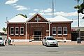
The Coonabarabran Post Office
-
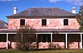
Old Coonabarabran Court House
-
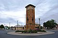
War memorial at Coonabarabran


