Lachlan River facts for kids
Quick facts for kids Lachlan River |
|
|---|---|

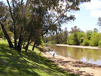
The Lachlan River at Cowra
|
|
| Country | Australia |
| Physical characteristics | |
| Main source | east of Gunning |
| River mouth | joins the Murrumbidgee River near Oxley |
| Length | 1450 km (901 mi) |
| Basin features | |
| Basin size | 84,700 km² |
The Lachlan River is a major river in central New South Wales, Australia. It flows for about 1,450 kilometers (901 miles). This river is very important for farming in the area.
Contents
Where the Lachlan River Flows
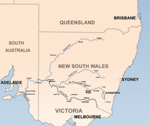
The Lachlan River begins in the mountains of New South Wales, close to a town called Gunning. Several other rivers flow into the Lachlan. These include the Boorowa River, the Belubula River, and the Abercrombie River. They all meet the Lachlan near the town of Cowra.
A large dam called Wyangala Dam was built near Cowra. This dam helps control the amount of water in the river. Unlike some other big rivers in Australia, like the Murrumbidgee River or the Murray River, the Lachlan does not get its water from melting snow. This means its water flow can change a lot.
Sometimes, the river has very little water. For example, in 1944, there was hardly any flow. But just six years later, in 1950, there was a huge amount of water. In very dry years, like from April 1944 to April 1945, the Lachlan River can even dry up completely in some parts.
The Lachlan River often floods. At the town of Forbes, it has flooded about every seven years since 1887.
The Lachlan River flows west, then south. It ends in a very large wetland called the Great Cumbung swamp. This swamp is near Oxley, between the towns of Hay and Balranald. The water from this big swamp, which covers about 500 square kilometers, eventually flows into the Murrumbidgee River. The Lachlan's water is mainly used to help farms grow crops.
History of the Lachlan River
The land around the Lachlan River has been home to the Aboriginal people called the Wiradjuri for thousands of years. Their land was known as "the land of the three rivers": the Wambool (Macquarie), the Kalare (Lachlan), and the Murrumbidjeri (Murrumbidgee). The Murray River was the southern border of their land.
The first European to discover the Lachlan River was a surveyor named George William Evans in 1815. He named the river after Lachlan Macquarie, who was the Governor of New South Wales at the time. Later, in 1817, another explorer named John Oxley explored the river further.
In the early days of New South Wales, the southern part of the Lachlan River was sometimes called the Fish River. However, as more of the area was explored, people realized it was all part of the same river, and the name Fish River was no longer used.
Major Floods in the Lachlan River
The Lachlan River has a history of big floods. In 1870, the river flooded so much that the water level reached 15.9 meters (about 52 feet) at Cowra.
One of the highest floods recorded at Forbes happened in June 1952. The river rose to 10.8 meters (about 35 feet) at the Forbes Iron Bridge. More than 900 families had to leave their homes. Many people were rescued from their rooftops by boats and even helicopters.
In August 1990, another flood caused water to enter 132 houses in Forbes. Two years later, in 1992, the floods were not as big, but farmers in the Lachlan Valley still lost about 30 percent of their lucerne crops, which is a type of plant grown for animal feed. Around 500 sheep also drowned in the Eugowra/Trundle area. Most of the 400 people living in Eugowra had to move to safety.
Other significant floods happened in: 1891, 1916, 1951, 1956, 1961, 1974, 1976, 1993, and 1998. Today, both Indigenous and non-Indigenous people live along the Lachlan River.
Life and Economy in the Lachlan Area
More than 100,000 people live in the area around the Lachlan River. This region is very important for farming in New South Wales. About 14% of all farm goods produced in New South Wales come from this area, even though it makes up only about 10% of the state's land. The Lachlan area is managed by 24 different local governments.
Related Pages
Major Rivers that Flow into the Lachlan
- Abercrombie River
- Boorowa River
- Belubula River
- Crookwell River
Towns Along the Lachlan
- Breadalbane
- Bevandale
- Reids Flat
- Wyangala Dam
- Darbys Falls
- Cowra
- Gooloogong
- Paytens Bridge
- Tomanbil
- Forbes
- Jemalong
- Bedgerebong
- Waroo
- Fairholme
- Condobolin
- Gunebang
- Eubalong
- Hillston
- Booligal
- Oxley
See also
 In Spanish: Río Lachlan para niños
 | Calvin Brent |
 | Walter T. Bailey |
 | Martha Cassell Thompson |
 | Alberta Jeannette Cassell |


