
Hay, New South Wales facts for kids
Quick facts for kids HayNew South Wales |
|||||||||
|---|---|---|---|---|---|---|---|---|---|

Looking south down Lachlan Street, the main street of Hay
|
|||||||||

Hay
Location in New South Wales
|
|||||||||
| Population | 2,882 (2021 census) | ||||||||
| Established | 1859 | ||||||||
| Postcode(s) | 2711 | ||||||||
| Elevation | 93.3 m (306 ft) | ||||||||
| Location | |||||||||
| LGA(s) | Hay Shire | ||||||||
| County | Waradgery | ||||||||
| State electorate(s) | Murray | ||||||||
| Federal Division(s) | Farrer | ||||||||
|
|||||||||
Hay is a town located in the western Riverina region of New South Wales, Australia. It's the main town for the Hay Shire area. Hay is known for its rich farms and wide, flat plains.
The town sits about halfway between Sydney and Adelaide. It's where three important highways meet: the Sturt, Cobb, and Mid-Western Highways. This makes Hay a key spot for transport across Australia. The town is built right next to the Murrumbidgee River, which is part of the huge Murray–Darling river system. Most of Hay's shops and businesses are on the north side of the river.
Contents
Discovering Hay's Past
Long ago, Aboriginal groups lived along the rivers and wetlands of the western Riverina. The area around Hay was a meeting place for the Nari-Nari and Wiradjuri peoples.
In 1829, Charles Sturt explored the Murrumbidgee River. He and his team traveled by boat all the way to the sea. By the late 1830s, settlers called "squatters" started to set up farms along the rivers. By the mid-1850s, these farms were doing well. The gold rushes in Victoria created a big demand for farm animals. The Riverina became a place to raise animals before sending them to market. One popular route crossed the Murrumbidgee River at a spot called Lang's Crossing-place.

Lang's Crossing: Where Hay Began
The area where Hay is now was first known as Lang's Crossing-place. It was named after three brothers named Lang who had farms nearby. This spot was a key river crossing on a busy route for moving farm animals to Victoria.
In 1856, Captain Francis Cadell, who was a pioneer of steam-powered boats on the Murray River, set up a store here. Soon after, in 1857, Thomas Simpson opened a blacksmith shop. A year later, Henry Leonard built a hotel and started a punt (a flat-bottomed boat) to cross the river. In 1858, steamboats successfully traveled up the Murrumbidgee River as far as Lang's Crossing-place.
The local landowner, Henry Jeffries, didn't want a town to grow here. He even tried to stop Henry Leonard from building his hotel. But people wanted a settlement, so the government sent a surveyor to map out a new town. Henry Leonard opened his hotel, the Murrumbidgee Punt Hotel, in October 1858. By mid-1859, the government officially set aside land for the town. In October 1859, the town was named "Hay" after John Hay, a wealthy farmer and politician.
Hay's Early Years: 1859 to 1880
The Post Office at Lang's Crossing Place opened in April 1859 and was renamed "Hay" in 1861. In 1860, a brick courthouse and jail were built.
In April 1861, a count of the people showed 172 people living in Hay. There were 115 males and 57 females. Most of the buildings were made of wood or were tents. Two new hotels, the Caledonian Hotel and the Argyle Hotel, also opened in 1861. The Caledonian Hotel was later badly damaged by fire in 2006.
By 1871, Hay's population had grown to 664 people. In November 1871, the people of Hay asked for their town to become a municipality, which means it would have its own local government. Elections were held in August 1872, and Frank Johns became the first mayor.
The first bridge over the Murrumbidgee River in Hay was built in 1872. It cost a lot of money, about £20,000. This bridge had a special part that could swing open to let steamboats pass through. It was officially opened on August 31, 1874, by Henry Parkes, a very important politician in New South Wales. This old bridge was replaced by a new one in 1973. The old swinging part of the bridge, last used in 1946, is now a display near the river.
As Hay grew, it became a central place for the surrounding farms. The farms provided many jobs. Hay had stores, hotels, a hospital, a post office, banks, a courthouse, and a police station. It became a busy port for steamboats, which brought supplies to the town and took wool bales back down the river.
The famous writer Joseph Furphy lived in Hay in the 1870s. He worked as a carrier, moving goods with a team of bullocks. Furphy later used the Hay area as the setting for his novel Such is Life.

In 1879–80, a new jail was built in Hay, replacing the old one. The new Hay Gaol opened in December 1880.

Growth and Changes: 1881 to 1914
Between 1881 and 1882, the railway line was extended to Hay from Narrandera. A new railway station was also built. This new line connected Hay directly to Sydney and opened in July 1882. The railway made it easier and cheaper to transport wool to Sydney, which changed Hay's focus from Melbourne to Sydney.
In 1883, the large Anglican church area of Goulburn was split. Hay became the main town for the new Diocese of Riverina. Bishop Sydney Linton was chosen to lead this new area. He arrived in Hay in 1885 and was officially welcomed in the old St Paul's church. A new St. Paul's church, which became the main church for the diocese, was finished by the end of 1885. In 1889, a special house called ‘Bishop’s Lodge’ was built for Bishop Linton. It was designed to handle Hay's hot summers and cold winters. Hay was the center of the Anglican Diocese of Riverina until 1953.
Hay During the World Wars
During the First World War, many men from Hay and the surrounding area joined the army. Hay had one of the highest rates of enlistment in Australia. Sadly, one out of every six men who joined from Hay died during the war. This had a very sad impact on the small communities in the Hay district.
After the war, in 1919, people decided to build a High School in Hay to remember those who died. The Hay War Memorial High School opened on Anzac Day, 1923.
Hay's Role in World War II

During World War II, Hay was chosen as a site for special camps because of its isolated location. Three high-security camps were built in 1940. The first people to arrive were over two thousand refugees from Nazi Germany and Austria. Many of them were Jewish. They had been gathered in Britain and sent to Australia on a ship called the HMT Dunera. They arrived in Hay on September 7, 1940, and were held in Camps 7 and 8.
These people became known as the 'Dunera Boys'. Their time in Hay was an important part of Australia's history. About 800 of them chose to stay in Australia after the war. Many of these men became very important in Australian culture, science, and business. Hay still remembers the 'Dunera Boys' fondly. Every year, the town holds a 'Dunera Day' where many of the surviving internees return to visit.
Later, in November 1940, Italian civilians were held in Camp 6. In May 1941, the 'Dunera Boys' left Hay. Then, Italian prisoners-of-war (POWs) were placed in Camps 7 and 8. In December 1941, Japanese civilians were brought to Camp 6. In April 1942, a farm was started where Italian internees and POWs could grow food.
After a prison break-out at Cowra in August 1944, 600 Japanese POWs were moved to Hay. They were held in the high-security Camps 7 and 8. The last Japanese POWs left Hay in March 1946. By June 1947, all the camps were taken down.
Historic Places in Hay
Hay has several places that are listed as important heritage sites:
- 355 Church Street: Hay Gaol
- 120 Lachlan Street: Hay Post Office
- Moama Street: Bishops Lodge
- Narrandera–Hay railway: Hay railway station
Hay's Landscape and Weather

Hay is located on a flat plain called the Riverine Plain. This plain is made of silt, clay, and sand that rivers deposited a very long time ago. The Murrumbidgee River, fed by snow, flows west across this plain. To the north, the Lachlan River also flows into this area. These two rivers meet in a network of swamps and channels between Hay and Balranald. South of the Murrumbidgee, the Billabong Creek flows into the Edward River, which is a branch of the Murray River.
Along the rivers near Hay, you'll find forests of River Red Gum trees. Further from the river, in lower areas, there are Black Box trees. Away from the river, Hay is surrounded by flat, mostly treeless plains. These plains used to be covered in saltbush plants, along with grasses and other small plants. However, much of the saltbush has been lost due to too many animals grazing, damage from rabbits, and large-scale farming. The plains around Hay also have many shallow creek beds, dry lakes, and sand-ridges formed by wind. Cypress-pine trees often grow on these sand-ridges.
Hay's Climate: Hot Summers, Cool Winters
Hay has a cold semi-arid climate. This means it has long, hot, and very sunny summers. Winters are cool and partly cloudy. Weather records have been kept since 1877, but extreme temperatures have only been recorded since 1957.
Temperatures can vary a lot throughout the year. Summers often reach over 40°C (104°F). Winters can see daytime temperatures drop below 10°C (50°F). The hottest temperature ever recorded in Hay was 47.7°C (117.9°F) on January 5, 2013. The coldest was -3.8°C (25.2°F) on August 3, 2014.
The average rainfall each year is 368.3 millimeters (14.5 inches). Hay is a very sunny place, with about 143 clear days each year. On July 24, 1936, a small amount of snow was reported in Hay. If true, this would be the lowest elevation snowfall ever seen in New South Wales, as Hay is only about 90 meters (295 feet) above sea level. The snow did not stay on the ground.
| Climate data for Hay (Miller Street, 1877–2015, extremes 1957–2015); 93 m AMSL; 34.52° S, 144.85° E | |||||||||||||
|---|---|---|---|---|---|---|---|---|---|---|---|---|---|
| Month | Jan | Feb | Mar | Apr | May | Jun | Jul | Aug | Sep | Oct | Nov | Dec | Year |
| Record high °C (°F) | 47.7 (117.9) |
47.5 (117.5) |
42.0 (107.6) |
37.3 (99.1) |
30.0 (86.0) |
25.7 (78.3) |
26.0 (78.8) |
30.6 (87.1) |
36.4 (97.5) |
39.2 (102.6) |
44.9 (112.8) |
45.4 (113.7) |
47.7 (117.9) |
| Mean daily maximum °C (°F) | 33.0 (91.4) |
32.5 (90.5) |
29.2 (84.6) |
24.1 (75.4) |
19.3 (66.7) |
15.8 (60.4) |
15.1 (59.2) |
17.3 (63.1) |
20.7 (69.3) |
24.5 (76.1) |
28.4 (83.1) |
31.2 (88.2) |
24.3 (75.7) |
| Mean daily minimum °C (°F) | 16.6 (61.9) |
16.5 (61.7) |
13.7 (56.7) |
9.9 (49.8) |
6.7 (44.1) |
4.5 (40.1) |
3.5 (38.3) |
4.6 (40.3) |
6.7 (44.1) |
9.5 (49.1) |
12.5 (54.5) |
14.9 (58.8) |
10.0 (50.0) |
| Record low °C (°F) | 5.5 (41.9) |
5.3 (41.5) |
4.5 (40.1) |
0.7 (33.3) |
−2.2 (28.0) |
−3.6 (25.5) |
−3.6 (25.5) |
−3.8 (25.2) |
−1.4 (29.5) |
0.0 (32.0) |
2.8 (37.0) |
5.7 (42.3) |
−3.8 (25.2) |
| Average rainfall mm (inches) | 27.6 (1.09) |
29.7 (1.17) |
30.2 (1.19) |
27.9 (1.10) |
34.7 (1.37) |
35.5 (1.40) |
31.3 (1.23) |
32.2 (1.27) |
31.4 (1.24) |
35.0 (1.38) |
26.0 (1.02) |
26.9 (1.06) |
368.3 (14.50) |
| Average rainy days (≥ 0.2 mm) | 3.6 | 3.4 | 3.9 | 4.5 | 6.3 | 8.0 | 8.6 | 8.5 | 6.7 | 6.2 | 4.6 | 4.1 | 68.4 |
| Average afternoon relative humidity (%) | 29 | 31 | 35 | 42 | 53 | 61 | 59 | 52 | 44 | 37 | 32 | 30 | 42 |
| Source: Bureau of Meteorology | |||||||||||||
Who Lives in Hay?
In 2021, the town of Hay had 2,882 people. About 8.3% of them were Indigenous. Most residents (80.0%) were born in Australia. Also, 84.0% of people spoke only English at home. A large part of the population (41.4%) is 55 years old or older.
When asked about religion, the most common answers were Catholic (27.6%), No Religion (24.3%), and Anglican (21.7%).
| Historical population | ||
|---|---|---|
| Year | Pop. | ±% |
| 1921 | 2,572 | — |
| 1933 | 3,156 | +22.7% |
| 1947 | 2,963 | −6.1% |
| 1954 | 3,009 | +1.6% |
| 1961 | 3,134 | +4.2% |
| 1966 | 2,959 | −5.6% |
| 1971 | 3,208 | +8.4% |
| 1976 | 2,872 | −10.5% |
| 1981 | 2,958 | +3.0% |
| 1986 | 2,961 | +0.1% |
| 1991 | 2,817 | −4.9% |
| 1996 | 2,896 | +2.8% |
| 2001 | 2,692 | −7.0% |
| 2006 | 2,636 | −2.1% |
| 2011 | 2,298 | −12.8% |
| 2016 | 2,316 | +0.8% |
| 2021 | 2,208 | −4.7% |
| Source: Australian Bureau of Statistics data. | ||
Getting Around Hay
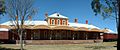
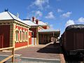
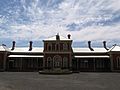
Hay's railway station is the end of the Hay branch line. However, the station is currently closed. The last passenger train ran in 1983, after 101 years of service. The train service for goods closed in 1984. The historic Hay Railway Station was restored in 2005. It even appears on an Australian stamp!
The Dunera Museum is located at the Hay Railway Station. It's housed in old train carriages. This museum tells the stories of over 6,600 German, Italian, Japanese, and Australian civilians and prisoners of war who were held in camps in Hay between 1940 and 1946.
Hay can be reached by the Cobb Highway, the Mid Western Highway, and the Sturt Highway. Bus services are available to Cootamundra, where you can catch trains to Sydney or Melbourne. Buses also go to Mildura. The Hay Bridge carries the Cobb Highway over the Murrumbidgee River in town.
-
Hay Station pano
-
Hay Station Platform
-
Hay Railway Station


Farming in Hay
Hay is a major area for growing wool and producing sheep meat in Australia. There are about 26 main sheep farms here. Cattle are also raised for meat. In areas where farms use irrigation (watering systems), crops like lettuce, pumpkins, tomatoes, garlic, corn, rockmelons, watermelons, and broccoli are grown and packaged. Hay is also the top producer in the Riverina region for safflower, lettuce, and broccoli.
In recent years, farmers in Hay have also started growing rice and cotton. The Hay Plain is sometimes called the "Hay Paddy" because of all the rice. While cotton growing has been tricky due to colder weather, rice production has grown a lot. A rice storage and drying center on the edge of town can dry up to 32,000 tonnes of rice before it's sent to a mill in Deniliquin.
Sports in Hay

Like many towns in the Riverina, Hay loves sports! People here play many different kinds of football.
The Hay Magpies are a Rugby league team. They play in a competition called Group 20, which includes teams from towns in the South Western Riverina. The Magpies have won many championships in their history.
The local Rugby Union team is the Hay Cutters. They play in the Southern Inland Rugby Union against teams from towns like Tumut and Albury.
The Hay Lions are an Australian Rules Football club. They started way back in 1876! They now play in the Golden Rivers Football League, which includes teams from small towns in northern Victoria and the western Riverina.
The Hay Jockey Club holds a popular annual horse race meeting in November. It's known as "the biggest day in the year" and has a fun, picnic-like atmosphere.
Media in Hay
The Australian Broadcasting Corporation (ABC) provides TV and radio stations to Hay. These include ABC TV, digital channels like ABC1, ABC2, ABC3, and ABC News 24. National radio stations like ABC Radio National are also available.
Other TV channels available in Hay are Prime7, WIN Television, and Network 10. Network 10 is only available through digital signals.
The Riverine Grazier is the local weekly newspaper. It was first published in 1873. The newspaper covers news for Hay, Booligal, and Ivanhoe. It is published every Wednesday. Other daily newspapers from Griffith, Sydney, and Melbourne can also be bought in Hay.
2HayFM is Hay's community radio station. It broadcasts on 92.1 FM and reaches about 100 kilometers (62 miles) around Hay. It plays music, news, and local information.
Hay on the Big Screen
In May 2022, parts of the Mad Max film Furiosa: A Mad Max Saga were filmed in Hay.
Famous People from Hay
- Ernest Anderson (a bishop)
- George Challis (rugby league player)
- Jodie Hicks (Australian rules footballer)
- Tom Ledwidge (Australian rules footballer)
- Geoff Milliken (cricketer)
- Air Marshal Warren George McDonald (a high-ranking officer in the Royal Australian Air Force)
