
Billabong Creek facts for kids
Quick facts for kids Billabong |
|
|---|---|

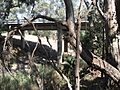
Billabong Creek at Moulamein
|
|

Location of the Billabong Creek mouth in New South Wales
|
|
| Other name(s) | Moulamein |
| Country | Australia |
| State | New South Wales |
| Region | Riverina (IBRA) |
| LGA | Federation Council |
| Towns | Morven, Culcairn, Walbundrie, Rand, Jerilderie, Conargo, Wanganella, Moulamein |
| Physical characteristics | |
| River mouth | confluence with the Edward River Moulamein 70 m (230 ft) 35°5′32″S 144°2′0″E / 35.09222°S 144.03333°E |
| Length | 320 km (200 mi) |
| Basin features | |
| River system | Murray catchment, Murray-Darling basin |
| Basin size | 791 km2 (305 sq mi) |
The Billabong Creek is a long waterway in the Riverina area of New South Wales, Australia. It's part of the huge Murray-Darling Basin, which is a big river system. A "billabong" is an Aboriginal word for a waterhole or a stream that sometimes separates from a main river.
This creek is super long! It stretches for about 320 kilometers (nearly 200 miles). Some people even think it might be as long as 596 kilometers (about 370 miles). Because of its length, Billabong Creek is thought to be the longest creek in the entire world!
Contents
Billabong Creek: The World's Longest Creek?
Billabong Creek is a special type of waterway called a perennial stream. This means it has water flowing in it for most or all of the year. It's a key part of the Murray-Darling Basin, which is one of the largest river systems on Earth. This basin covers a huge part of southeastern Australia.
The creek is famous for its incredible length. At 320 kilometers (about 200 miles), it's considered the longest creek in the world. Some measurements even suggest it could be much longer, reaching up to 596 kilometers (about 370 miles).
Where Does Billabong Creek Flow?
Starting Point and Journey
Billabong Creek begins when two smaller creeks, Yarra Yarra Creek and Little Billabong Creek, join together. This joining point is called a confluence. The creek starts high up on the Great Dividing Range, which is a long mountain range in eastern Australia. Its starting point is north of a town called Holbrook.
From there, the creek flows mostly west and northwest. As it travels, 16 smaller streams, known as tributaries, flow into it, adding more water. The creek drops about 252 meters (827 feet) in height from its source to its end.
Towns Along the Way
As Billabong Creek makes its long journey, it passes through many towns. These towns include Morven, Culcairn, Walbundrie, Rand, Jerilderie, Conargo, Wanganella, and Moulamein.
Where the Creek Ends
Finally, Billabong Creek reaches its end at Moulamein. Here, it joins another important waterway called the Edward River. This is where the creek's long journey finishes.
What Makes Billabong Creek Special?
Catchment Area
The area of land that collects rainwater and channels it into Billabong Creek is called its catchment area. For Billabong Creek, this area is about 791 square kilometers (305 square miles). This means a lot of land contributes water to the creek.
Important Waterway
Billabong Creek is a very important natural drainage line. It helps move water between two much larger rivers: the Murray River and the Murrumbidgee River. It acts like a natural channel connecting these big river systems.
Gallery
-
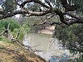
Billabong Creek at Rand
-
Billabong Creek at Wanganella


