
Waradgery County facts for kids
Quick facts for kids WaradgeryNew South Wales |
|||||||||||||||
|---|---|---|---|---|---|---|---|---|---|---|---|---|---|---|---|

Location in New South Wales
|
|||||||||||||||
|
|||||||||||||||
Waradgery County is a special area in New South Wales, Australia. It is one of 141 "cadastral divisions." These are like old-fashioned land areas used for mapping and keeping property records. The main town in Waradgery County is Hay.
The county is located where the Lachlan River and the Murrumbidgee River meet. The Lachlan River forms the northern edge of the county. The Murrumbidgee River is the southern border for a short part. Waradgery County also includes some land south of the Murrumbidgee River, close to Hay.
What's in the Name?
The name Waradgery comes from a local Aboriginal word. It is likely linked to the Wiradjuri people. The Wiradjuri are one of the largest Aboriginal groups in New South Wales. Their traditional lands cover a big part of central New South Wales.
Smaller Land Areas: Parishes
Within Waradgery County, there are many smaller land areas called parishes. These parishes are also used for mapping and land records. They help to divide the county into smaller, easier-to-manage sections. Each parish has its own name and location.
Images for kids
-
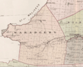
Wajadgery County NSW as shown on John Sands' 1886 map
.png)
