Hillston, New South Wales facts for kids
Quick facts for kids HillstonNew South Wales |
|||||||||
|---|---|---|---|---|---|---|---|---|---|

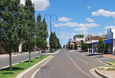
High Street, the main street of Hillston
|
|||||||||
| Population | 1,547 (2021 census) | ||||||||
| Established | 1863 | ||||||||
| Postcode(s) | 2675 | ||||||||
| Elevation | 122.0 m (400 ft) | ||||||||
| Location | |||||||||
| LGA(s) | Carrathool Shire | ||||||||
| County | Nicholson | ||||||||
| State electorate(s) | Murray | ||||||||
| Federal Division(s) | Riverina | ||||||||
|
|||||||||
Hillston is a town in western New South Wales, Australia. It is located in Carrathool Shire, right on the banks of the Lachlan River. The town was started in 1863. In 2021, about 1,547 people lived there.
Contents
History of Hillston

Early Explorers
In 1817, John Oxley and his exploration team were the first Europeans to visit the Hillston area. Oxley wrote in his journal that the land was "uninhabitable and useless."
Later, in 1839, William Hovell followed the Lachlan River. He reached a spot near where Hillston is today. He then set up a large farm called "Bellingerambil," which was later renamed "Cowl Cowl."
How Hillston Got Its Name
The area where Hillston now stands was a place where animals could cross the Lachlan River. At first, Europeans called it 'Daisy Plains' or 'Daisy Hill'. It was later known as "Redbank." This name came from the local Wiradjuri people's word 'Melnunni', meaning "red soil."
In 1863, a stockman named William Ward Hill built an inn, which is like a hotel, called the Redbank Hotel. He was from a nearby farm called "Roto." William Hill passed away in 1867. His wife, Elizabeth, then ran the hotel for several years. In 1869, when the first post office opened, the town was renamed Hillston. It was named after William Hill, who started the hotel.
The land for Hillston was first owned by John McGee. He divided his land into smaller parts and sold them. The government also planned a town just north of McGee’s land. Both areas sold well. This meant two parts of the town grew side-by-side.
Hillston grew by providing services to the big farms around it. The town's growth depended on how well these farms were doing. For example, a drought in the mid-1860s slowed down the town's progress. But better weather later on helped Hillston grow again.
Township Development
As Hillston grew, more businesses opened. The Moss brothers, who owned stores in another town called Hay, opened a store in Hillston by 1869. The Hillston Post Office started on February 1, 1869.
The first Police Court in Hillston was held in 1873. It took place in a room at one of the town's hotels.
The first church in Hillston was Anglican. A Roman Catholic church was built in the 1880s. The first agricultural show was held in Hillston in 1881. A hospital was built in 1882. People raised money for it by giving donations. A new post office was finished in 1883, and a courthouse was also completed around that time.
Hillston became a municipality in 1888. This meant it could govern itself more.
A large store called Nall, Jackson & Co. Ltd. started in 1889. This company became very important to Hillston and the surrounding area.
A Presbyterian Church was built in Hillston in 1890.
Modern Changes
After World War I, the Hillston area was divided into smaller farms. Soldiers returning from the war were given these farms. This was part of a plan called the New South Wales soldier settlement scheme. The railway line between Griffith and Hillston was finished in 1923. More land became available for farming along this new railway.
By the late 1920s, many new people moved to the area. This led to growth in Hillston. A new lighting system was put in place in 1929. Hotels were updated and new shops were built. In 1931, the railway line to Roto was completed.
However, many of the soldier settlement farms were too small to make enough money. This caused difficulties for many families. Some families had to leave their farms, and Hillston's growth slowed down.
In the 1950s, a boom in wool farming brought new hope and rebuilding to the town. But the town faced challenges again in the 1960s and 1970s.
Until the early 1970s, the main road, the Kidman Way, was rough dirt. This made it hard to travel to other towns. A train service ran until the mid-1970s, but now there is no public transport to Hillston.
In the late 1990s, growing cotton brought another boom to Hillston. After a big drought from 2002 to 2007, cotton farming is growing strong again.
In August 2021, a new high-tech weather radar was opened in Hillston. It helps the Bureau of Meteorology track weather across the region.
Heritage Listings
Hillston has some important historical places. One of them is:
- Willandra National Park: Willandra Homestead
Climate
Hillston has a dry climate, known as a cold semi-arid climate. This means it has long, hot summers and cooler winters. Weather records have been kept in Hillston since 1881.
The highest temperature ever recorded was 47.2 degrees Celsius on January 11, 2017. The lowest was -4.6 degrees Celsius on August 3, 2014. On average, Hillston gets about 375.2 millimeters of rain each year. Snow has never been recorded in Hillston.
| Climate data for Hillston Airport (1907–2024, rainfall to 1881); 122 m AMSL; 33.49° S, 145.52° E | |||||||||||||
|---|---|---|---|---|---|---|---|---|---|---|---|---|---|
| Month | Jan | Feb | Mar | Apr | May | Jun | Jul | Aug | Sep | Oct | Nov | Dec | Year |
| Record high °C (°F) | 47.0 (116.6) |
47.2 (117.0) |
42.0 (107.6) |
38.2 (100.8) |
30.0 (86.0) |
26.0 (78.8) |
26.2 (79.2) |
30.7 (87.3) |
37.6 (99.7) |
39.8 (103.6) |
43.8 (110.8) |
45.5 (113.9) |
47.2 (117.0) |
| Mean daily maximum °C (°F) | 33.6 (92.5) |
32.8 (91.0) |
29.3 (84.7) |
24.4 (75.9) |
19.4 (66.9) |
15.8 (60.4) |
15.1 (59.2) |
17.2 (63.0) |
20.9 (69.6) |
24.8 (76.6) |
28.6 (83.5) |
31.6 (88.9) |
24.5 (76.0) |
| Mean daily minimum °C (°F) | 18.5 (65.3) |
18.3 (64.9) |
15.2 (59.4) |
10.6 (51.1) |
7.3 (45.1) |
4.8 (40.6) |
3.8 (38.8) |
4.9 (40.8) |
7.1 (44.8) |
10.4 (50.7) |
13.8 (56.8) |
16.4 (61.5) |
10.9 (51.7) |
| Record low °C (°F) | 6.0 (42.8) |
7.7 (45.9) |
4.5 (40.1) |
0.5 (32.9) |
−3.2 (26.2) |
−4.0 (24.8) |
−4.4 (24.1) |
−4.6 (23.7) |
−2.2 (28.0) |
1.0 (33.8) |
2.4 (36.3) |
4.4 (39.9) |
−4.6 (23.7) |
| Average precipitation mm (inches) | 32.0 (1.26) |
27.0 (1.06) |
33.3 (1.31) |
28.0 (1.10) |
32.9 (1.30) |
35.2 (1.39) |
30.3 (1.19) |
30.7 (1.21) |
28.7 (1.13) |
36.5 (1.44) |
30.6 (1.20) |
30.1 (1.19) |
375.2 (14.77) |
| Average precipitation days (≥ 0.2 mm) | 3.9 | 3.4 | 3.8 | 4.2 | 5.5 | 7.2 | 7.5 | 7.3 | 5.8 | 5.8 | 4.3 | 4.1 | 62.8 |
| Average afternoon relative humidity (%) | 29 | 32 | 36 | 42 | 52 | 59 | 57 | 50 | 43 | 38 | 31 | 29 | 41 |
Industry
Farming is the main industry in Hillston. Farmers raise animals and grow crops like grain, cotton, citrus fruits, and vegetables. They use water from the Lachlan River and from underground sources to irrigate their fields.
Many road transport companies work in Hillston. This is because the town is close to important roads like the Kidman Way, Lachlan Valley Way, and the Cobb Highway.
| Historical population | ||
|---|---|---|
| Year | Pop. | ±% |
| 1921 | 546 | — |
| 1933 | 1,137 | +108.2% |
| 1947 | — | |
| 1954 | 1,019 | — |
| 1961 | — | |
| 1966 | 1,036 | — |
| 1971 | 1,009 | −2.6% |
| 1976 | 889 | −11.9% |
| 1981 | 999 | +12.4% |
| 1986 | 1,052 | +5.3% |
| 1991 | 1,030 | −2.1% |
| 1996 | 1,099 | +6.7% |
| 2001 | 1,209 | +10.0% |
| 2006 | 1,054 | −12.8% |
| 2011 | 996 | −5.5% |
| 2016 | 1,093 | +9.7% |
| 2021 | 1,149 | +5.1% |
| Source: Australian Bureau of Statistics data. | ||
Amenities and Fun Things to Do
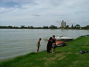
Hillston has many facilities for its residents. Lake Woorabinda is a man-made lake where people can go water-skiing. There's also a walking track around the lake, between the river and the lake. The town has a community hall for sports and cultural events, and an art gallery on the main street.
Near Lake Woorabinda and the community hall, you'll find a 25-meter public swimming pool. There's also the Lions' Park, which has playground equipment for kids and a barbecue area for picnics.
Hillston has two schools:
- Hillston Central School: A public school for students from kindergarten to Year 12.
- St Joseph's Primary School: A Catholic school for students from kindergarten to Year 6.
Stan Peters Oval is the local sports ground. It's home to the Hillston Swans, an Australian Rules football club in the Northern Riverina Football League. It's also where the Hillston Bluebirds, a Rugby League club, play in Group 17.
The Temora–Roto railway line ends in Hillston. Passenger trains stopped running in 1974, but the line is still used to transport goods to and from Hillston.
 | Precious Adams |
 | Lauren Anderson |
 | Janet Collins |


