
Weather radar facts for kids

A weather radar is a special machine that uses radar to see where rain, snow, or hail is falling. It helps us know if precipitation is coming our way. Weather radars can also tell us how fast the precipitation is moving. They can even tell us what type of precipitation it is. This helps forecasters predict future weather.
Modern weather radars are mostly Doppler radars. These radars are very clever. They can find out how fast raindrops are moving. They also measure how heavy the rain or snow is. This information helps scientists understand storms better. It can also help them tell if a storm might cause severe weather, like tornadoes or strong thunderstorms.
Contents
How Weather Radar Works
Weather radar sends out radio waves. These waves travel through the air. When the waves hit raindrops, snowflakes, or hail, they bounce back. The radar then listens for these bounced-back waves.
Seeing Precipitation
The radar measures how long it takes for the waves to return. This tells us how far away the precipitation is. It also measures how strong the bounced-back waves are. Stronger waves mean heavier rain or snow. This is how the radar creates a picture of where precipitation is falling.
Understanding Movement with Doppler Radar
Most modern weather radars use something called the Doppler effect. This is the same effect you hear when an ambulance siren changes pitch as it drives past you. For radar, it means the waves change slightly if the rain is moving towards or away from the radar.
By measuring this change, the radar can tell us if the rain is moving towards it or away from it. It can also tell us how fast the rain is moving. This is very useful for seeing how storms are developing. It helps forecasters spot dangerous winds inside storms.
What Weather Radar Shows Us
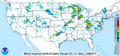
Weather radar images show different colors. These colors represent how heavy the precipitation is. Green usually means light rain. Yellow and orange mean heavier rain. Red often means very heavy rain or hail.
Tracking Storms
Forecasters use radar to track storms as they move. They can see if a storm is getting stronger or weaker. They can also see the direction a storm is heading. This helps them warn people about incoming bad weather.
Spotting Severe Weather
Doppler radar is especially good at finding severe weather. It can detect rotating winds inside thunderstorms. This rotation can be a sign that a tornado might form. Radar can also show areas of strong winds or large hail. This allows weather experts to issue warnings to keep people safe.
Images for kids
-
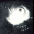
Typhoon Cobra as seen on a ship's radar screen in December 1944.
-
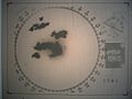
1960s radar technology detected tornado producing supercells over the Minneapolis-Saint Paul metropolitan area.
-
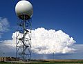
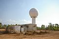
NEXRAD in South Dakota with a supercell in the background.
-
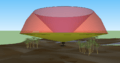
Scanned volume by using multiple elevation angles
-

NWS color scale of reflectivities.
-
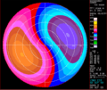
Idealized example of Doppler output. Approaching velocities are in blue and receding velocities are in red. Notice the sinusoidal variation of speed when going around the display at a particular range.
-
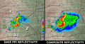
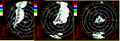
Base PPI versus Composite.
-
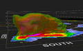
Vertical cross-section.
-
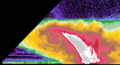
Image of an RHI.
-
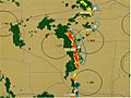
Map of the RIDGE presentation of 2011 Joplin tornado.
-
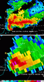
A supercell thunderstorm seen from two radars almost colocated. The top image is from a TDWR and the bottom one from a NEXRAD.
-
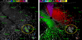
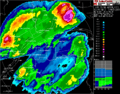
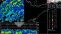
Reflectivity (left) and radial velocities (right) southeast of a NEXRAD weather radar. Echoes in circles are from a wind farm.
-
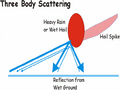
Example of strong attenuation when a line of thunderstorms moves over (from left to right images) a 5 cm wavelength weather radar (red arrow). Source: Environment Canada
-
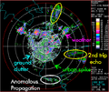
Radar image of reflectivity with many non-weather echoes.
-
Phased Array Weather Radar in Norman, Oklahoma
-
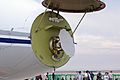
Global Express Weather radar with radome up
-
Nowcasting a line of thunderstorms from AutoNowcaster system
-
NOAA NEXRAD radar image of the Park Forest, IL, meteorite fall of 26 March 2003.
-
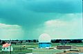
Weather radar in Norman, Oklahoma with rainshaft
-

University of Oklahoma OU-PRIME C-band, polarimetric, weather radar during construction
-
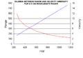
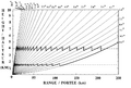
Maximum range from reflectivity (red) and unambiguous Doppler velocity range (blue) with pulse repetition frequency
-
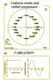
Radial component of real winds when scanning through 360 degrees
-
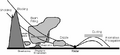
Typical angles scanned in Canada. The zigzags represent data angles used to make CAPPIs at 1.5 km and 4 km of altitude.
-
24 hours rain accumulation on the Val d'Irène radar in Eastern Canada. Notice the zones without data in the East and Southwest caused by radar beam blocking from mountains.
-
Berrimah Radar in Darwin, Northern Territory Australia
-
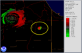
The square in this Doppler image has been automatically placed by the radar program to spot the position of a mesocyclone. Notice the inbound/outbound doublet (blue/yellow) with the zero velocity line (gray) parallel to the radial to the radar (up right). It is noteworthy to mention that the change in wind direction here occurs over less than 10 km.
-
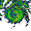
PPI reflectivity loop (in dBZ) showing the evolution of a hurricane
-
-
Profiler high resolution view of a thunderstorm (top) and by a weather radar (bottom).
-
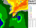
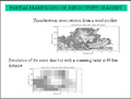
1.5 km altitude CAPPI at the top with strong contamination from the brightband (yellows). The vertical cut at the bottom shows that this strong return is only above ground.
-


_(2563231232).png)


.jpg)


See also
 In Spanish: Radar meteorológico para niños
