
Mesocyclone facts for kids

A mesocyclone is a spinning column of air found inside a big, strong storm. Imagine a giant invisible top spinning in the sky! This spinning air is usually about 2 to 10 kilometers (about 1 to 6 miles) wide. It's a key part of how some of the most powerful storms, like supercell thunderstorms, work.
Mesocyclones are special because the air inside them rises and spins at the same time. This spinning motion often happens in the same direction that big low pressure areas spin on weather maps. They are usually linked to a small area of very low pressure right inside a thunderstorm. These kinds of storms can bring really strong winds and lots of hail.
Contents
What is a Mesocyclone?
A mesocyclone is basically a rotating updraft. An updraft is a strong current of air moving upwards. In a mesocyclone, this rising air also spins around. This spinning motion is what makes these storms so powerful.
How it Forms
Mesocyclones form when there's a change in wind speed or direction as you go higher in the atmosphere. This is called "wind shear." When wind shear happens, it can create a horizontal tube of spinning air. As strong updrafts in a thunderstorm pull this spinning air upwards, the tube tilts vertically. This creates the spinning column of air we call a mesocyclone.
Why They Are Important
Mesocyclones are very important because they can lead to the formation of tornadoes. Not every mesocyclone creates a tornado, but most strong tornadoes come from storms that have a mesocyclone. The intense spinning motion helps to concentrate the air, making it spin even faster and tighter, which can then form a tornado.
Where Mesocyclones Happen
Mesocyclones are usually found in supercell thunderstorms. Supercells are a type of thunderstorm that has a deep, rotating updraft. They are often the strongest and most dangerous types of thunderstorms.
Size of Mesocyclones
Compared to other weather systems, mesocyclones are quite small. They are bigger than a single tornado but much smaller than a large storm system that covers hundreds of kilometers. Their size is just right to help create the conditions needed for tornadoes.
How We Spot Them
Weather scientists use radar to spot mesocyclones. Radar sends out radio waves that bounce off rain, hail, and even dust in the air. By looking at how these waves return, scientists can see the movement of air inside a storm. A special pattern on the radar screen, often called a "hook echo," can show where a mesocyclone is spinning.
Visual Clues
Sometimes, you can see clues that a mesocyclone is present. A rotating wall cloud is a common sign. A wall cloud is a lowered, rotating cloud base that forms beneath the main updraft of a supercell. If you see a wall cloud spinning, it means there's a mesocyclone above it, and a tornado might form.
Images for kids
-
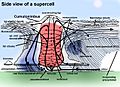
Supercell diagram with the mesocyclone rotation in red.
-
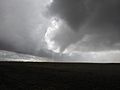
A tornado developing under a wall cloud within a mesocyclone near Falcon, Colorado
-
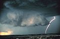
Mesocyclones are sometimes visually identifiable by a rotating wall cloud like the one in this thunderstorm over Texas.
-
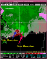
Mesocyclone detection algorithm output on tornadic cells in Northern Michigan on July 3, 1999.


See also
 In Spanish: Mesociclón para niños
| Cyclones and Tropical cyclones of the World |
|---|
| Cyclone - Tropical - Extratropical - Subtropical - Mesocyclone - Polar cyclone - Polar low |
