
Cowra facts for kids
Quick facts for kids CowraNew South Wales |
|||||||||
|---|---|---|---|---|---|---|---|---|---|
  .jpg)   From top to bottom, left to right: Kendal Street divides the CBD; the Eastern entrance to the town, near Europa Park; Crops of canola creating fields of gold;Australia's World Peace Bell proudly housed in Cowra's Civic Square; and the Lachlan River which flows through the heart of the town
|
|||||||||

Cowra
Location in New South Wales
|
|||||||||
| Population | 9,863 (2016 census) | ||||||||
| Established | 1846 | ||||||||
| Gazetted | 1849 | ||||||||
| Postcode(s) | 2794 | ||||||||
| Elevation | 310 m (1,017 ft) | ||||||||
| Time zone | AEST (UTC+10) | ||||||||
| • Summer (DST) | AEDT (UTC+11) | ||||||||
| Location | |||||||||
| LGA(s) | Cowra Shire | ||||||||
| County | Forbes, Bathurst | ||||||||
| State electorate(s) | Cootamundra | ||||||||
| Federal Division(s) | Riverina | ||||||||
|
|||||||||
Cowra is a town in the Central West region of New South Wales, Australia. It is the biggest town and the main office for the Cowra Shire. About 9,863 people live there.
Cowra is located about 310 metres (1,017 feet) above sea level. It sits on the banks of the Lachlan River in the Lachlan Valley. If you drive from Sydney, the state capital, it's about 310 kilometres (193 miles) west. From Canberra, Australia's capital, it's about 189 kilometres (117 miles) north. The town is where three main highways meet: the Mid-Western Highway, Olympic Highway, and the Lachlan Valley Way.
Contents
History of Cowra
The first explorer to visit the Lachlan Valley was George William Evans in 1815. He named the area the Oxley Plains. In 1817, he thought the land was not good for people to settle.
The town of "Coura Rocks" started in 1844. Around 1847, it became known as Cowra. In 1849, it was officially named a village.
In the 1850s, many gold miners passed through Cowra. They were heading to gold fields like Lambing Flat and Grenfell. The first school in Cowra opened in 1857. A bridge was built over the Lachlan River in 1870.
Gold was found at Mount McDonald in the 1880s. The railway from Sydney reached Cowra in 1886. Cowra got its own local government in 1888. The first telephone system started in 1901. The town got its water supply in 1909 and electricity in 1924.
Cowra holds a yearly Festival of International Understanding. This festival has a parade and shows off different cultures.
Historic Places in Cowra
Cowra has several places that are important for their history. These include:
- The Lachlan River railway bridge, Cowra on the Blayney–Harden railway line.
- The Cowra railway station.
- The Cowra Prisoner of War Camp Site on Evans Street.
Climate in Cowra
Cowra has a mild climate, which means it's not too hot or too cold. In summer, the average high temperature is about 32°C (90°F). In winter, the average high is about 14°C (57°F). The lowest temperatures range from 16°C (61°F) in summer to 2°C (36°F) in winter.
Cowra is located between the cool, wet mountains and the hot, dry plains. Because of this, it gets weather from both areas. Winters can be very cold with frost and sometimes snow. Summers can have many days over 40°C (104°F).
Rainfall is spread out evenly throughout the year. The average yearly rainfall is 598.3 mm (23.56 inches). The wettest month ever recorded was January 1984, with 371.0 mm (14.61 inches) of rain.
| Climate data for Cowra Airport (1966-2015) | |||||||||||||
|---|---|---|---|---|---|---|---|---|---|---|---|---|---|
| Month | Jan | Feb | Mar | Apr | May | Jun | Jul | Aug | Sep | Oct | Nov | Dec | Year |
| Record high °C (°F) | 46.6 (115.9) |
44.2 (111.6) |
39.5 (103.1) |
36.0 (96.8) |
27.0 (80.6) |
24.0 (75.2) |
22.0 (71.6) |
34.4 (93.9) |
33.5 (92.3) |
36.7 (98.1) |
43.8 (110.8) |
41.8 (107.2) |
46.6 (115.9) |
| Mean daily maximum °C (°F) | 31.9 (89.4) |
30.7 (87.3) |
28.1 (82.6) |
23.6 (74.5) |
18.6 (65.5) |
14.7 (58.5) |
13.7 (56.7) |
15.5 (59.9) |
18.6 (65.5) |
22.7 (72.9) |
26.7 (80.1) |
30.2 (86.4) |
23.0 (73.4) |
| Mean daily minimum °C (°F) | 15.6 (60.1) |
15.6 (60.1) |
12.5 (54.5) |
8.3 (46.9) |
5.1 (41.2) |
3.1 (37.6) |
2.1 (35.8) |
2.8 (37.0) |
4.5 (40.1) |
7.0 (44.6) |
10.2 (50.4) |
13.1 (55.6) |
8.3 (46.9) |
| Record low °C (°F) | 5.0 (41.0) |
5.0 (41.0) |
0.6 (33.1) |
−3.0 (26.6) |
−5.0 (23.0) |
−5.5 (22.1) |
−8.0 (17.6) |
−6.0 (21.2) |
−3.0 (26.6) |
−2.0 (28.4) |
−2.0 (28.4) |
2.0 (35.6) |
−8.0 (17.6) |
| Average rainfall mm (inches) | 59.6 (2.35) |
52.9 (2.08) |
40.4 (1.59) |
42.8 (1.69) |
46.3 (1.82) |
40.5 (1.59) |
52.5 (2.07) |
47.8 (1.88) |
52.5 (2.07) |
56.3 (2.22) |
53.3 (2.10) |
53.4 (2.10) |
598.3 (23.56) |
| Average rainy days (≥ 0.2mm) | 6.5 | 5.7 | 5.8 | 5.5 | 7.6 | 9.4 | 11.0 | 10.2 | 9.1 | 8.2 | 7.8 | 6.5 | 93.3 |
| Average relative humidity (%) | 34 | 37 | 39 | 44 | 54 | 63 | 62 | 57 | 53 | 47 | 39 | 32 | 47 |
| Source: Bureau of Meteorology | |||||||||||||
Education in Cowra
Cowra has several schools for different age groups.
Primary Schools
- Cowra Public School
- Mulyan Public School
- Holman Place Public School
- St Raphael's Catholic School (for students from Kindergarten to Year 6)
Secondary Schools
- Cowra High School (for students from Year 7 to Year 12)
- St Raphael's Catholic School (for students from Year 7 to Year 12)
Cowra also has a campus of the Western Institute of TAFE. This is a place where people can learn job skills.
Local Industries
Cowra is known for growing grapes and making wine. This industry started in the 1970s. At first, they mostly grew Chardonnay grapes. Now, they grow many other types of grapes too.
You can also find many shops in Cowra. Some of the larger stores include:
- Coles (supermarket)
- Woolworths (supermarket)
- Aldi (supermarket)
- Bunnings Warehouse (hardware store)
Japanese War Cemetery
There is a special cemetery in Cowra for Japanese prisoners of war. It holds the bodies of 231 prisoners who died during the Cowra Breakout. This event happened during World War II when Japanese prisoners tried to escape. After the war, people from Cowra helped care for the cemetery.
In 1964, the site officially became the Japanese War Cemetery. Later, more Japanese soldiers and civilians who died in Australia were moved here. The cemetery is a sign of respect for those who died.
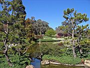
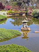
Cowra Japanese Garden
Near the war cemetery is the Cowra Japanese Garden and Cultural Centre. It was designed in 1977 by Ken Nakajima, a famous Japanese garden architect. The garden is the largest Japanese garden in the Southern Hemisphere, covering five hectares (12 acres).
The garden is designed in the style of the Edo period in Japan. It has rocky hills, carefully trimmed hedges, waterfalls, and streams. There are also two lakes that are home to many birds. Special parts of the garden include a large bell, a traditional Edo-style house, a tea house, and a Bonsai House. The garden changes with the seasons, showing different parts of Japan's landscape.
Every year in September, the garden hosts the Sakura Matsuri (cherry blossom festival). This festival celebrates spring when the cherry trees bloom. Visitors can enjoy traditional Japanese culture during this time.
-
Japanese lake with stone lantern
-
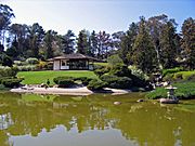
Looking across the lake to the teahouse
-
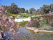
Lower lake with spring blossoms
-
Big bird rests on a stone lantern in the upper lake
-
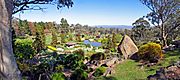
Panoramic view from the Symbolic Mountain at the Japanese Gardens


Sports in Cowra
The most popular sport in Cowra is rugby league. The local team is called the Cowra Magpies. They play in the Peter McDonald Premiership.
Sporting Clubs
- Cowra Magpies (rugby league)
- Cowra Eagles (rugby union)
- Cowra Blues (Australian rules football)
- Cowra Eagles (soccer)
- Cowra Netball association (netball)
- Cowra Squashed Frogs (hockey)
Population Growth
The number of people living in Cowra has changed over the years.
| Historical population | ||
|---|---|---|
| Year | Pop. | ±% |
| 1921 | 3,716 | — |
| 1933 | 5,056 | +36.1% |
| 1947 | 5,473 | +8.2% |
| 1954 | 6,097 | +11.4% |
| 1961 | 6,288 | +3.1% |
| 1966 | 7,076 | +12.5% |
| 1971 | 7,295 | +3.1% |
| 1976 | 7,734 | +6.0% |
| 1981 | 7,900 | +2.1% |
| 1986 | 8,207 | +3.9% |
| 1991 | 8,422 | +2.6% |
| 1996 | 8,544 | +1.4% |
| 2001 | 8,691 | +1.7% |
| 2006 | 8,430 | −3.0% |
| 2011 | 8,107 | −3.8% |
| 2016 | 8,225 | +1.5% |
| 2021 | 8,254 | +0.4% |
| Source: Australian Bureau of Statistics data. | ||
Famous People from Cowra
- Ellie Carpenter (born 2000) is a soccer player. She plays for Olympique Lyon and for the Australian national team.
