
Wyangala facts for kids
Quick facts for kids WyangalaNew South Wales |
|||||||||
|---|---|---|---|---|---|---|---|---|---|

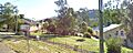
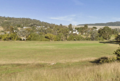
Wyangala village, looking towards St Vincent's Church (permanently closed), corner of Waugoola and Wirong Rds.
|
|||||||||

Wyangala
Location in New South Wales
|
|||||||||
| Postcode(s) | 2808 | ||||||||
| Elevation | 341 m (1,119 ft) | ||||||||
| Location | |||||||||
| LGA(s) | Cowra Shire | ||||||||
| County | King County | ||||||||
| State electorate(s) | Cootamundra | ||||||||
| Federal Division(s) | Riverina | ||||||||
|
|||||||||
Wyangala is a small village in the Lachlan Valley in New South Wales, Australia. It sits near where the Abercrombie and Lachlan Rivers meet, just below the huge Wyangala Dam wall. Wyangala is about 320 kilometers (200 miles) west of Sydney. The name also refers to the wider area around the village.
The village got its name from an Indigenous word. It is thought to be from the Wiradjuri language, but its exact meaning is not known. The Wiradjuri people were the first inhabitants of the Lachlan Valley. They lived along the rivers and on open land. Their way of life changed after British explorers, John Oxley and George William Evans, explored the valley in 1815. European settlers arrived in the 1830s, which led to conflicts with the Wiradjuri people.
The current village of Wyangala was built in 1928. This was during the time the Wyangala Dam was being constructed. Before this, there was an older settlement called Wyangala Flats. It was established in the 1840s. This older settlement was covered by water when Wyangala Dam was finished in 1935.
Wyangala grew a lot when the dam was being built. However, its population became much smaller in the years after. Many houses were removed, and most businesses closed. Today, Wyangala has a small primary school (currently closed), a Catholic church (also closed), sports fields, and parks. There are no very old buildings here. The village was mainly built to house the dam construction workers.
Fun things to do in the area include visiting Lake Wyangala. People use the lake for power generation, water sports, and fishing. There is also a nine-hole golf course, walking trails, and mountain bike trails. You can also see the 1.37 kilometer (0.85 mile) long dam wall. Wyangala has a warm climate. It is home to many different native and non-native plants and animals. Some of these are rare or endangered. The area is hilly with lots of granite rocks and boulders.
Contents
History of Wyangala
Wiradjuri People and Early European Settlement
Wiradjuri people were the first people to live in the Wyangala area. They were skilled hunters, fishers, and gatherers. They wore cloaks made from possum skins. They lived along river flats and open areas near rivers. The Wiradjuri were, and still are, the largest Indigenous group in New South Wales. Their traditional lands covered the Macquarie, Lachlan, and Murrumbidgee rivers.
Scientists have found over 200 Wiradjuri campsites around Wyangala. This shows that many Indigenous people lived here a long time ago. Campsites were often on gentle hills, high spots, or flat areas near the Lachlan River.
The name 'Wyangala' (pronounced why-ang-gah-lah) comes from a Wiradjuri word. Its exact meaning is unknown. However, similar words in the Wiradjuri language can mean "troublesome" or "bad white." The village and the older Wyangala Flats settlement got this name.

On May 27, 1815, George William Evans was the first European to find the start of the Lachlan River. He named it after the NSW Governor, Lachlan Macquarie. Two years later, Evans and John Oxley explored the Lachlan River. They met the Wiradjuri people and noted their language was different from those on the coast. Oxley could not go further due to marshland. He thought the middle of Australia was "uninhabitable."
Despite Oxley's view, Europeans started settling the area a few years later. In 1831, Arthur Rankin and James Sloan were the first white settlers in the Valley. They were cattlemen from Bathurst. Settling on Wiradjuri lands led to conflicts. By the 1840s, land at Wyangala Flats was being sold. By 1860, land at Wyangala was selling for £1 an acre. Until the dam was built in 1935, the land was mainly used for growing wool.
Conflicts with the Wiradjuri people became less common by the 1850s. This was because gold mining and new land laws brought more settlers. The large number of Europeans took over traditional lands. They also destroyed sacred sites. New diseases also greatly affected the Indigenous population. This led to the Wiradjuri people being moved from their lands and their numbers decreasing.
Gold and Bushrangers in the Area


Gold mining was popular in the nearby Mount McDonald area. This happened in the late 1800s and early 1900s. Two gold-rich quartz reefs were found in 1880. Donald McDonald and his group found the gold while exploring the mountains near Wyangala. McDonald saw sunlight reflecting off something under a tree. As news spread, miners came to the area. The town of Mount McDonald "grew in the midst of the forest." At its busiest, the town had:
- About 600 people living there.
- A school.
- At least one Catholic Church.
- Banks.
- A general store.
- A doctor.
- Many pubs.
By the late 1920s, mining slowed down, and the town disappeared. Its school closed in December 1924. Today, only about 4 or 5 houses remain where Mount McDonald once stood.
Some gold and gems were also found along the Lachlan River at Wyangala in the early 1900s. However, it was not enough to be mined commercially.
The discovery of gold led to more bushranger activity. In the 1860s and 1870s, the Lachlan Valley had problems with bushrangers. Famous gangs included those led by Frank Gardiner, John Gilbert, and Ben Hall. Frank Gardiner was one of the most successful bushrangers. His biggest robbery was in 1862 at Eugowra Rocks. Gardiner, along with Ben Hall and John Gilbert, robbed a "gold escort." They stole between £14,000 and £22,000 in gold and cash. It was rumored that Gardiner buried his share of the gold in a mountain cave near Wyangala.
The gold was never found. Gardiner was sent to prison and later exiled to the United States. Five years after the robbery, an Irishman came to New South Wales with a map from Gardiner. Even with the map, the gold was never found. By the late 1800s, police became better at catching bushrangers. This led to less crime. More people moved to the region, and new communication and transport systems were built.
20th Century Developments
By the early 1900s, the Lachlan Valley faced problems because river flows were unreliable. In 1902, the government saw a need to save water. Repeated droughts were harming farming and causing many animals to die. They looked at ways to fix this. One idea was to build a reservoir at Wyangala. Earlier studies showed Wyangala was the best place for a large water storage. These talks eventually led to the building of the 1935 dam and the start of today's Wyangala village.
Building the Dam (1928–1935)

To help the region grow and provide a steady water supply, the Burrinjuck Dam and Wyangala Dam were built. The official start of the £1.3 million project was on December 17, 1928. The NSW Premier, Sir Thomas Bavin, started the work. Instead of digging soil, they used explosives to remove tons of earth and rock.
The "galvanized-iron town of Wyangala" was built to house the workers. It was on land once owned by the Green family, who were early settlers. By January 1930, Wyangala was a busy place. There were 450 workers and their families in the village. 74 children attended the new primary school. A local resident described the town:
- It had a post and telegraph office.
- Two stores and two bakeries.
- A police station and a doctor.
- A butcher shop, a public hall, and a school.
- One church and a boarding-house for workers.
- A bank and a temporary power house.
- About 40 private homes.
The resident also noted that the dam water would cover their house. A new road was built from Woodstock to the dam. A bus ran from Woodstock to the dam three times a week.
This big project had its dangers. Four men died during the dam's construction.
The original settlement and cemetery were covered by water when the dam was finished in 1935.
Dam Upgrade (1961–1971)

The original dam was not big enough to hold the huge floods of 1952. Also, more water was needed for farming. So, Wyangala Dam was upgraded and made larger from 1961 to 1971. Workers and their families lived in temporary homes in the village. Like the first dam build, these buildings were simple and practical. This means Wyangala does not have many old, historically important buildings.
The ten-year, £18 million project made the dam three times bigger. The upgraded lake covered 5,390 hectares (13,300 acres). It could hold 1,220,000 megaliters (322 billion US gallons) of water. This is two and a half times the size of Sydney Harbour. The area that collects water for the dam was 8,300 square kilometers (3,200 square miles).
The opening ceremony for the upgraded dam was planned for February 8, 1971. Sir Roden Cutler, Governor of NSW, was to open it. But heavy rains and floods delayed it until August 6, 1971. Over 2,000 guests attended. After the dam opened, Wyangala's population dropped a lot. Houses used by workers were removed. Only the houses seen today, below the dam wall, remained.
Post Office, School, and Church

By March 1929, with dam construction underway, up to 60 letters arrived every day or two. This was when a vehicle traveled from Cowra to Wyangala. With over 350 workers and their families, not having a post office was a problem. To fix this, Wyangala Dam Post Office opened on March 14, 1929. The new post office used a special stamp for mail.
Over the years, the village post office became very important. It provided postal services and sometimes banking services. It also had a manual telephone exchange. The postmaster or postmistress ran the telephone exchange along with the post office. The telephone exchange became automatic in the late 1980s. The post office itself closed in 1998.
Wyangala Dam Public School opened in 1929, soon after the post office. It was the second school in the area. The school has been in three different places in the village. First, it was near the bowling club. Then, it was near the Vic Roworth Conference Center. Finally, in the 1960s, it moved to its current spot on Waugoola Road. There was an even earlier school at Wyangala. It ran for six years and closed in 1913.
The number of children at the school changed a lot. It was over 70 in 1930, 160 in the 1960s, and over 20 in the early 1980s. By the 2000s, it was under 10. As of July 2022, the school is not operating due to low student numbers.
The first church in Wyangala was a small building made of timber and iron. It was built during the 1935 dam construction. Like the school, it was first near the country club. After the dam was finished, a man named Bert Priddle bought the church. He moved it to a property near Grenfell. It became an Anglican church on November 17, 1935.
The current church, St Vincent's, was built in the center of the village. It was built with cinder blocks and an iron roof. It officially opened on November 19, 1954. The day after, a storm knocked down the back wall. This delayed the first mass until December 5, 1954.
Community Life in Wyangala
Education, Church, and Sports

The village has a small primary school, Wyangala Dam Public School. It is on Waugoola Road and usually has one teacher. Students come from the nearby rural area, Wyangala village, Darbys Falls, and the Mt McDonald area. The school focuses on learning about the environment and creative arts. As of July 2022, the school is not operating because there are not enough students.

Not far from the school, also on Waugoola Road, is St Vincent's Catholic church. It sometimes serves as a community hall for village activities. Mass services used to be held here. However, as of December 16, 2023, the Catholic Diocese of Bathurst announced its permanent closure. Two other local churches also closed at the same time.
Next to the village, there is a nine-hole golf course, a bowling green, tennis courts, and a cricket field. The Wyangala Country Club manages these facilities.
In August 2013, the Wyangala Cricket Oval was renamed Matt Morrison Oval. This was to honor Matt Morrison, who had passed away earlier that year. He helped develop the cricket oval and sponsored the Wyangala Golf Club.
Sports clubs in Wyangala include fishing, cricket, golf, bowling, and ski clubs. The Fishing Club (Wyangala Danglers) has regular events and competitions. The Cricket Club plays in a district competition with teams from nearby towns. The Golf Club has occasional challenges. The Bowling Club holds regular casual meetings. The Ski Club has a clubhouse on Main Beach of Wyangala Dam and holds events during the year.
Food, Services, and Attractions

The Wyangala Country Club is on the hillside opposite the village. It has a restaurant called the Country Club Bistro, a bar, and entertainment. Locals meet at the club for sports club meetings. They also discuss important village issues and other community activities here.
The village Service Station and store is at the entrance to the nearby Wyangala Waters State Park. The store sells fishing and camping supplies. It also has take away food and other goods.
Wyangala has two places for conferences. One is the Vic Roworth Conference Center in the village. The other is the community hall in Wyangala Waters State Park. Both can seat many people.
There is one holiday house in the village, near Wyangala Dam Public School. More places to stay are at Wyangala Waters State Park. It has many camping sites with and without power. It also has five bungalows, three cottages, one lodge, seven cabins, and Jayco ensuite cabins.
As early as the mid-1930s, Wyangala was seen as a major tourist spot. It was also an important fishing area for the Lachlan Valley. Reg Hailstone, a local leader in the 1940s and 1950s, dreamed of turning Wyangala into a "national playground." While Wyangala never became a huge "tourist resort," Hailstone's idea of a national playground came true over the years.

Lake Wyangala (the water in the Dam) is a popular place for fishing. In spring and summer, Lake Wyangala is also used for water sports. These include canoeing, jet-skiing, sailing, swimming, and water skiing. There are walking and mountain bike trails through the bushland near the village and State Park. You can also rent a houseboat to explore the lake and fish. The waterslides in the Park are currently not working. Dissipater Park, just below the Dam wall, has BBQ facilities for picnics.
The 1.37 kilometer (0.85 mile) long Dam wall is a famous landmark. It is 85 meters (279 feet) high, as tall as a 25-story building. It is 304 meters (997 feet) wide at its base. You can see it from many places around the village and from nearby lookouts. You can also see it from many kilometers away on Darbys Falls Road. In the past, you could drive across the top of the wall. However, since June 2014, vehicles cannot drive on it. A new road and bridge were built downstream of the village.
Geography and Nature
Location and People

Wyangala is in New South Wales, Australia. It is about 320 kilometers (200 miles) west of Sydney. It is in an area called the South West Slopes. This region stretches from north of Cowra down into western Victoria.
The number of people living in Wyangala changed over the years. It dropped from 227 in 2011 to 182 in 2016. At the 2021 census, the population of Wyangala had increased to 216.
In 2016, 42.8% of the people were female and 57.2% were male. The average age was 57 years, which is 19 years older than the Australian average. 77.7% of people in Wyangala were born in Australia. Other countries of birth included England (4.0%), New Zealand (2.3%), and Scotland (2.3%). The main religions were Anglican (30.3%), No Religion (24.0%), Catholic (23.4%), and Uniting Church (4.6%).
Most people (65.6%) worked full-time, and 18.8% worked part-time. The unemployment rate was 6.2%, which was lower than the national average. The main jobs were Managers (28.8%), Clerical and Administrative Workers (16.9%), and Labourers (11.9%). The average rent was $100 per week. The average mortgage payment was $910 per month.
Water Resources
The Lachlan Valley is a region in New South Wales (NSW). It goes from Crookwell in the east to Oxley in the west. It covers a catchment area of 84,700 square kilometers (32,700 square miles). This is 10% of NSW. In 2005, this area produced 14% of the state's farm goods. Lake Wyangala is the only major water storage in the Valley. It supplies water to over 88,000 hectares (217,000 acres) of irrigated land. Water from the dam is used for farming, industry, mining, and recreation. It also provides water for towns and helps protect water habitats.
A hydro-electric power station is located below the Wyangala Dam wall, next to the village. It generates an average of 42.9 gigawatt-hours of electricity each year. This is enough power for almost 6,400 households.
Plants, Animals, and Geology
Wyangala has many different native and non-native plants and animals. Some of these are vulnerable, threatened, or endangered. Here are some of the plants and animals found in and around the village:
| Plants | Mammals | Birds | Reptiles | Amphibians | Fish | |||||
|---|---|---|---|---|---|---|---|---|---|---|
| Acacia | Eastern bentwing bat | Brown treecreeper | Bobtail | Booroolong frog | Bream | |||||
| Bathurst burr | Eastern grey kangaroo | Diamond firetail | Eastern brown snake | Common eastern froglet | Brown and Rainbow Trout | |||||
| Cypress pine | Echidnas | Galah | Eastern ctenotus | Lesueur's frog | Carp | |||||
| Eucalyptus | Greater long-eared bat | Laughing kookaburra | Eastern long-necked turtle | Peron's tree frog | Catfish | |||||
| Hoary sunray | Native mice | Red-browed finch | Marbled gecko | Red-crowned toadlet | Murray Cod | |||||
| Native grasses | Rabbits | Regent honeyeater | Nobbi dragon | Sloane's froglet | Silver Perch | |||||
| Native flowers | Spotted‐tail quoll | Speckled warbler | Rich ctenotus | Tyler's toadlet | Golden Perch | |||||
| Scotch thistle | Sugar glider | Superb parrot | Thick-tailed gecko | White's tree frog | Macquarie Perch |

The plants and animals live in an area called the Lachlan Fold Belt. This area has folded and faulted rocks. It has Early Silurian Wyangala Granite. This granite has pushed into and changed older Ordovician rocks.
The land around Wyangala has many granite rock outcrops and large boulders. These are scattered across a hilly landscape. This greatly affects the soils in the area. The soils are mostly formed from the weathering of granite. They include thin, stony soils on steep slopes. On lower slopes, there are naturally acidic and sodic soils. These soils can easily break down. They are prone to erosion, losing nutrients, and salinity.
The climate in Wyangala is warm and temperate. It gets a lot of rain throughout the year. It is classified as Cfa by the Köppen climate classification. The average yearly temperature in Wyangala is 15.2°C (59.4°F). It receives about 600 millimeters (23.6 inches) of precipitation. January is the warmest month, with an average temperature of 23.9°C (75.0°F). July is the coldest month, with an average temperature of 7.9°C (46.2°F).
The difference in rainfall between the driest and wettest months is 17.5 millimeters (0.69 inches). Average temperatures change by 16°C (28.8°F) during the year.
Recent Times
Earthquake in 2006
In October 2006, a magnitude 4 earthquake was felt across the New South Wales Central West. The earthquake's center was at Wyangala. An earthquake of this size is called "Light" on the Richter scale. It usually causes indoor objects to shake and make rattling noises. The State Water Corporation checked Wyangala Dam for damage. They found that the dam's pressure and seepage gauges were not affected. No damage or injuries were reported in the village or State Park.
Dam Wall Road Closure

In 2009, the NSW State Water Corporation announced plans to close the public road over Wyangala Dam wall forever. This was due to new security rules and safety requirements. This new rule was planned to happen with a big upgrade to make the Dam wall higher. State Water suggested that people use Mt McDonald Road as an alternative. This news made locals angry. They felt the problems of such a change had not been thought about. Concerns included:
- Children would have to travel 60 kilometers (37 miles) to school instead of 5 kilometers (3 miles).
- Local workers on the "wrong" side of the dam wall would have a long detour.
- Mt McDonald road had narrow curves and bends, making it dangerous.
- Emergency services vehicles would take longer to reach Wyangala.
- The Wyangala Waters State Park and Country Club might lose visitors. It was thought that over 75% of visitors came via the Dam wall road.
Local people, emergency services, and local councils voiced their concerns. This led to a review of the decision to reroute traffic. A report by Ian Armstrong suggested building a bridge across the Lachlan River. This bridge would be downstream of the village. Most locals agreed this was the only good option.
In June 2014, the bridge (Wyangala Bridge) and new road (Trout Farm Road) were finished.
Removal of Waterslides
At the start of 2013, Wyangala Waters State Park looked for companies to remove the waterslides. The slides had not been used because the Park management could not find a suitable operator. This unexpected announcement caused a big campaign to save the slides.
After the public outcry, the former NSW Deputy Premier, Andrew Stoner, paused the plans to remove the slides. He also decided to appoint a group to review the slides' future. Locals and the shire mayor, Bill West, welcomed this decision. They thought the slides were "a very important tourist attraction" and a "popular part of Cowra Shire." No decision has been made about the future of the slides.
Closure of School
In 2015, only 5 students were attending Wyangala Dam Public School. This big drop in numbers was because the Wyangala community had an ageing population. There were also no new young families in the village. So, the school was at risk of closing if student numbers did not increase. A meeting was held on June 23, 2015, to discuss the school's future. Village residents and former students could ask questions and argue for keeping the school open. The NSW Department of Education and Training was to decide the school's future later. In 2015, village residents started a group to attract new students. This campaign continued for several years. Despite these efforts, the school is currently not operating due to low student numbers.
Fuel Service
In May 2018, fuel services at Wyangala and other inland waterways closed. This was due to health and safety concerns and a need to upgrade facilities. Visitors were also not allowed to bring their own fuel. This meant they had to refuel in nearby Cowra. After a short bidding period, Petrolink Engineering was chosen in October 2018 to replace the fuel facilities. They aimed to have fuel back before Christmas 2018, but it was not restored until February 2019.
Raising Dam Wall Height
In 2018, former New South Wales Minister for Primary Industries and Regional Water, Niall Blair, suggested making the Wyangala Dam wall 10 meters (33 feet) higher. This was "to give greater water security for residents and farmers along the Lachlan River." The change was meant to increase water storage by 50%. It would also provide more capacity during floods. Besides the direct costs, current camping areas and other buildings would need to be moved. This was because of higher water levels after the work.
In October 2019, A$650 million was set aside to raise the dam wall by 10 meters. This 650 gigaliter (172 billion US gallon) increase in dam storage was to be funded equally by the State and Federal governments. The Deputy Prime Minister at the time, Michael McCormack, said the project was a "significant investment for the future." It would help secure water supplies during droughts. Work was planned to start in 2020 and finish by 2025.
However, as of October 2023, the proposed upgrade has been cancelled. This was due to increased costs and environmental concerns.
Images for kids
-
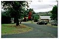
Wyangala village, looking towards St Vincent's Church (permanently closed), corner of Waugoola and Wirong Rds.
-
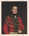
Portrait of Lachlan Macquarie 1874
-
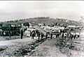
Mt McDonald, ca. 1900
-
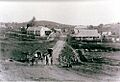
Mt McDonald, near Wyangala, late 1800s
-
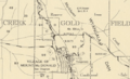
The Mt McDonald town plan at the end of the 19th century
-
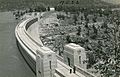
1935 Wyangala Dam wall
-
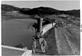
Wyangala Dam upgrade construction, November 1966
-
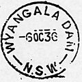
The Wyangala Dam Post Office first postmark
-
Wyangala Dam Public School
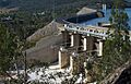
-
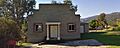
Village church, Wyangala
-
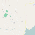
Street map of Wyangala village area
-
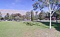
Dissipater Park, below Wyangala Dam wall
-
Wyangala village with the Dam wall in the background, Matt Morrison Oval in foreground
-
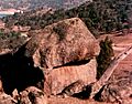
Granite boulder, Thompson's Lookout, Wyangala
-
Wyangala Dam spillway with road running along the top
