
Mount Kosciuszko facts for kids
Quick facts for kids Mount Kosciuszko |
|
|---|---|
| Tar-gan-gil/Kunama Namadgi | |

Mount Kosciuszko viewed from the Summit Walk
|
|
| Highest point | |
| Elevation | 2,228 m (7,310 ft) |
| Prominence | 2,228 m (7,310 ft) |
| Isolation | 1,894.26 km (1,177.04 mi) |
| Listing | |
| Geography | |

Mount Kosciuszko
Location in New South Wales

Mount Kosciuszko
Location in Victoria

Mount Kosciuszko
Location in Australia
|
|
| Parent range | Main Range, Great Dividing Range |
| Topo map | Perisher Valley |
| Climbing | |
| Easiest route | Walk (dirt road) |
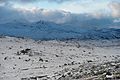
Mount Kosciuszko is the highest mountain on the mainland of Australia. It stands at 2,228 metres (7,310 feet) above sea level. The mountain is located in the Snowy Mountains region of New South Wales, inside Kosciuszko National Park.
The name of the mountain is pronounced koz-ee-US-koh. It is named after a Polish national hero, Tadeusz Kościuszko. The traditional Aboriginal name for the area is Kunama Namadgi, but there are several other names as well.
Contents
Naming the Mountain
_-_Google_Art_Project.jpg)

A Polish Explorer's Discovery
In 1840, a Polish explorer named Paweł Edmund Strzelecki was the first European to climb to the top of the mountain. He decided to name it Mount Kosciuszko to honour Tadeusz Kościuszko.
Tadeusz Kościuszko was a famous general who fought for freedom in both Poland and the American Revolutionary War. Strzelecki thought the mountain looked like the Kościuszko Mound, a famous monument in Kraków, Poland, that was built to honour the general.
A Mix-Up with Maps
For a while, there was some confusion about which nearby mountain was the tallest. Early maps sometimes mixed up Mount Kosciuszko with its neighbour, Mount Townsend. This led to some explorers climbing the wrong peak, thinking it was the highest!
Later, map experts checked the records and confirmed that the mountain Strzelecki named is truly the highest on the Australian mainland. The second-highest mountain was officially named Mount Townsend.
Aboriginal Names
The area around Mount Kosciuszko is the traditional land of the Ngarigo people. For thousands of years, they have had their own names for the mountains. Some of these names, like Tar-gan-gil, are related to the Bogong moth, an insect that gathers on the mountain in summer.
In 2019, a proposal was made to give the mountain a dual name: "Kunama Namadgi." The group that suggested it said the name means "snow" and "mountain." However, some Ngarigo elders disagreed. They said the name was not from their language and had a different, unsuitable meaning. The discussion about finding the right traditional name continues.
Geography and Nature
Mount Kosciuszko was formed millions of years ago when land was pushed upwards by forces deep inside the Earth. It was not created by a volcano. The top of the mountain is covered in large granite boulders that have been shaped by weather over a very long time.
Many unique plants grow on the mountain, including:
- Kosciuszko buttercup (Ranunculus anemoneus)
- Vickery's grass (Rytidosperma vickeryae)
- A type of Phebalium bush
- Billy buttons (a yellow, ball-shaped flower)
- Snow gum trees
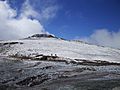
How to Reach the Summit
Mount Kosciuszko is one of the easiest of the Seven Summits (the highest mountains on each continent) to climb. There are several well-marked tracks to the top.
Main Walking Tracks
The most popular way to the summit starts from the top of the Kosciuszko Express chairlift at the Thredbo ski resort. This walk is about 13 kilometres for a round trip and takes a few hours. Much of the path is a raised metal walkway, which helps protect the fragile alpine plants from being stepped on.
Another route starts from Charlotte Pass. This walk is longer, at about 18 kilometres for a round trip. Until 1977, you could drive a car almost to the top, but the road was closed to protect the environment. Now, it is a popular path for hikers and cyclists.
At Rawson Pass, where the two main tracks meet, you can find Australia's highest public toilet. It was built in 2007 for the thousands of visitors who hike there each summer.
The Hannel's Spur Challenge
For a much more difficult hike, there is the Hannel's Spur Track. It is the route that Paweł Strzelecki first used in 1840. It is also the path that stockmen used to lead cattle up the mountain for summer grazing. This track is very steep and is Australia's biggest vertical climb, rising 1,800 metres from the valley below.
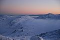
Visiting in Winter
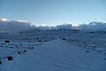
From about June to October, the mountain is covered in snow. The tracks are marked with snow poles to guide cross-country skiers.
|
||||||||||||||


Recreation and Sports

Kosciuszko National Park is a popular place for outdoor activities. In winter, it is home to Australia's largest ski resorts, including Thredbo, Charlotte Pass, and Perisher.
Each December, a very long running race called the Coast to Kosciuszko takes place. Runners start at the coast and run 240 kilometres, finishing at the summit of Mount Kosciuszko.
Australia's Other High Peaks
While Mount Kosciuszko is the highest mountain on the Australian mainland, there are higher peaks in territories that Australia manages.
- Mawson Peak (2,745 m) is on Heard Island in the southern ocean.
- In the Australian Antarctic Territory, there are even taller mountains, like Dome Argus (4,030 m) and Mount McClintock (3,490 m).
The highest mountain on the entire Australian continent (which includes the island of New Guinea) is Puncak Jaya in Indonesia. It is 4,884 metres high.
Gallery
-
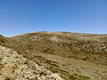
Mt Kosciuszko pictured in summer, without snow
-
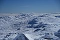
Kosciuszko National Park as viewed from the summit
-
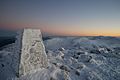
The base of a survey trig marker at the summit
-

East side of the mountain
-
Mount Kosciuszko Summit walk
-
The summit from Charlotte Pass, New South Wales
-
Mount Etheridge from south side showing high elevation toilet at Rawson Pass
-
View of Mount Kosciuszko and the Etheridge Range from the headwaters of the Snowy River
-
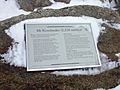
The plate at the top
-
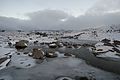
The Snowy River flowing down from the summit.
-
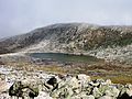
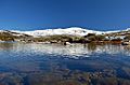
Lake Cootapatamba, the highest lake on the Australian mainland
-
Adjacent mountain ranges


See also
 In Spanish: Monte Kosciuszko para niños
- Australian Alps
- Australian Alps National Parks and Reserves
- List of mountains of Australia
