
Perisher Ski Resort facts for kids
Quick facts for kids Perisher |
|
|---|---|

Mount Perisher at 2,054 m (6,739 ft)
|
|
| Location | Perisher Valley |
| Nearest city | Canberra |
| Coordinates | 36°24′S 148°25′E / 36.4°S 148.41°E |
| Top elevation | 2,054 metres (6,739 ft) |
| Base elevation | 1,720 metres (5,640 ft) |
| Skiable area | 1,245 hectares (3,080 acres) |
| Runs | |
| Longest run | ~4 kilometres (2.5 mi) (Top of Perisher Quad Express to Bottom of Blue Calf T-Bar) |
| Lift system | 47 lifts |
| Snowfall | 190 centimetres (75 in) (median) [1] |
| Website | http://www.perisher.com.au |
Perisher Ski Resort is the biggest ski resort in the Southern Hemisphere. It used to be called Perisher Blue until 2009. You can find it in the Snowy Mountains of Australia.
Perisher is actually made up of four different ski villages. These are Perisher Valley, Smiggin Holes, Guthega, and Blue Cow. All these areas together cover about 12 square kilometers. The lowest part of the resort is at 1,720 meters above sea level. The highest point is the top of Mount Perisher, at 2,054 meters.
To make sure there's always enough snow, Perisher uses 240 special machines called snow guns. These guns can make artificial snow to add to the natural snowfall. In 2015, a company from the United States called Vail Resorts bought Perisher.
You can get to the resort by road or by a special train called the Skitube. This train is Australia's only underground rack railway. The best time for skiing is usually in July and August. The official ski season runs from the second weekend in June to the first weekend of October.
Perisher has 47 ski lifts to help you get around. These include an eight-seater chairlift, fast quad chairlifts, and many T-Bars and magic carpets. The ski runs are divided by difficulty: 42% are for beginners, 45% are for intermediate skiers, and 12% are for advanced skiers.
Contents
Discovering Perisher's Past
The Snowy Mountains area has a very long history. Aboriginal people lived here for about 20,000 years. They would gather in the High Country during summer to feast on bogong moths. Europeans first explored the area in 1835. In 1840, Edmund Strzelecki climbed Mount Kosciuszko and named it.
Later, cattle graziers used the Snowy Mountains for their animals in summer. The famous poem "The Man From Snowy River" by Banjo Paterson tells stories from this time. These graziers left behind many mountain huts that you can still see today.
Perisher ski resort is located inside Kosciuszko National Park. This park started as a protected area in 1906. It became a National Park in 1967.
The four villages that make up Perisher today started as separate ski resorts. They developed between 1939 and 1987. Smiggin Holes began as a stop for people traveling to Charlotte Pass. Perisher and Guthega grew because of the Snowy Mountains Scheme. Blue Cow was the last new resort built in the Snowy Mountains.
In 1995, Perisher Smiggins and Alpine Australia Group (which included Blue Cow and Guthega) joined together. This created Perisher Blue, which brought all four resorts into one big area. Today, it's simply known as Perisher. By 2009, Perisher had 47 lifts and covered 1,245 hectares.
Perisher Valley: The Main Hub

There's a story that the name "Perisher" came from James Spencer, an early settler. He supposedly said "What a perisher!" when he got caught in a storm in the 1840s. For many years, mountain graziers used this area in the summer.
The building of the huge Snowy Mountains Hydro-Electric Scheme from 1949 really helped the ski industry grow in the Snowy Mountains. This led to Perisher becoming a major Australian resort. The first ski lodges opened in 1951. By 1957, many ski clubs were operating.
As more skiers visited, the services and ways to get there improved. The first lodges in Perisher were built in 1952. In 1953, the first oversnow transport started taking people to Perisher Valley. Everyone there cheered and celebrated its arrival!
In 1958, Svere Kaaten, another mountain pioneer, built a modern rope tow at North Perisher. His friend Ken Murray built another rope tow and Perisher's first T-bar. Development continued, and the Mount Perisher Double Chairlift opened in 1961. With more chairlifts and T-bars, the Perisher area became very popular.
Over the years, different companies owned and managed the resort. In 1995, Perisher and Smiggins joined with Blue Cow and Guthega to form Perisher Blue.
By 2008, Perisher Valley had 30 connected ski lifts. It also had over 100 ski instructors and many snowmaking machines. The village offers lots of places to stay during winter.
Perisher Valley is the main village of the Perisher Ski Resort. Most of the places to stay right on the snow are here. Some of the biggest hotels include The Marritz Hotel, The Perisher Manor, The Man from Snowy River, and The Eiger Chalet.
| Perisher Valley ski lifts | Lift type |
|---|---|
| Eyre | T-Bar |
| International | T-Bar |
| Mt. Perisher Triple | Chairlift |
| Sun Valley | T-Bar |
| Olympic | T-Bar |
| Happy Valley | T-Bar |
| Leichhardt | Chairlift |
| Home Rope Tow | Rope tow |
| Lawson | T-Bar |
| Blaxland | T-Bar |
| Wentworth | T-Bar |
| Quad Express | Chairlift |
| Pretty Valley Double | Chairlift |
| Telemark | T-Bar |
| North Perisher | T-Bar |
| Interceptor Quad | Chairlift |
| Sturt | T-Bar |
| Village 8 Express | Chairlift |
| Mitchell | T-Bar |
| Tom Thumb | Magic carpet |
| Ski Carpet 1 | Magic carpet |
| Ski Carpet 2 | Magic carpet |
| Ski Carpet 3 | Magic carpet |
| Ski Carpet 4 | Magic carpet |
| Ski Carpet 5 | Magic carpet |
Smiggin Holes: Great for Beginners

The high Snowy Mountains were used by farmers for summer grazing for a long time. The name "Smiggin Holes" is thought to be Scottish. It refers to the holes filled with water that cattle made by walking on the ground.
The first Kosciuszko Chalet was built at Charlotte Pass in 1930. This made it easier to reach Australia's highest areas. More and more skiers wanted to go to Charlotte Pass. So, a cafe was set up at Smiggin Holes around 1939. From there, horse-drawn sleighs would take skiers to start their tough journey to the Kosciusko Chalet.
Kosciuszko National Park was created in 1906. It became a National Park in 1967. The park helped end the summer grazing industry. However, the Snowy Mountains Hydro-Electric Scheme (built from 1949-1974) helped develop Skiing in New South Wales. This included the steeper areas around Mount Perisher, near Smiggins.
Today, Smiggin Holes is part of the larger Perisher Ski Resort. It has places to stay and is perfect for beginner skiers.
| Smiggin Holes ski lifts | Lift type |
|---|---|
| Piper | T-Bar |
| Link | T-Bar |
| Burke | T-Bar |
| Wills | T-Bar |
| Kaaten Triple | Chairlift |
| Hume | T-Bar |
| Captain Cook | J-Bar |
| Scott | J-Bar |
| Zoe's | Magic carpet |
| Harry & Herman's | Magic carpet |
Blue Cow: A Later Addition

After 1840, a grazier named James Spencer leased all the high country, including Kosciuszko and Blue Cow peaks. His home was near the entrance to Kosciuszko National Park. Spencer apparently bred cattle with blue-gray coats. Blue Cow Mountain was named after one of these cows. This cow would disappear after the snow melted each year and would always be found on the mountain before the next winter.
In the 1970s, studies were done to develop skiing at Mount Blue Cow. This was because more ski areas were needed in the park. In 1984, the plan by Mount Blue Cow Ski Bowl Pty Limited was chosen.
The last major ski field in New South Wales was developed at Blue Cow Mountain in the 1980s. In 1987, the Skitube Alpine Railway opened. This Swiss-designed train took skiers from Bullocks Flat to Perisher Valley and then to Blue Cow. Blue Cow also opened in 1987.
The people who ran Blue Cow bought Guthega in 1991. The two resorts then joined with Perisher-Smiggins to become the biggest ski resort in the Southern Hemisphere. Blue Cow opened in July 1987. Even with some transport issues at first, people loved the new facilities and the mountain.
Today, Blue Cow includes the Blue Cow Resort Centre (at 1905m) and Guthega Ski Centre (at 1640m). The highest point you can reach by lift on the Blue Cow side of Perisher is 1960m. This is reached by the Summit Quad Chairlift. Blue Cow has 14 ski lifts that are open daily during winter. They also have snowmaking machines that cover an area serviced by six lifts.
| Blue Cow ski lifts | Lift type |
|---|---|
| Ridge Quad | Chairlift |
| Summit Quad | Chairlift |
| Early Starter Double | Chairlift |
| Terminal Quad | Chairlift |
| Brumby | T-Bar |
| Pleasant Valley Quad | Chairlift |
| Pony Ride | Magic carpet |
| Snowsports School Rope Tow | Rope tow |
Guthega: A Quiet Spot
.JPG)
Guthega Resort was started in the 1950s, just like Perisher Valley and Smiggin Holes. Access to the mountains improved because of the Snowy Mountains Hydro Electric Scheme. Also, many European workers who loved skiing came to the area. This helped skiing grow in New South Wales. When the Guthega Dam was built, skiers came to the isolated Guthega area. A rope tow was installed there in 1957.
Guthega stayed a small, separate resort for a while. It was a bit "out of the way," with only a few lodges and lifts. Not many day skiers visited because the roads were harder to drive on compared to Smiggin Holes or Perisher Valley.
In 1982, the Car Park chairlift was added. This meant visitors didn't have to walk uphill to reach the first lift, making the resort more appealing.
In 1991, Guthega was bought by the company that ran the Blue Cow Resort. This led to the two resorts working together in 1992. Now, you could get to Guthega by the Skitube alpine railway and the ski slopes from Blue Cow.
In 2013-2014, the Freedom Quad Chair was built. It opened for the 2014 season. This new chairlift made it easier to access ski areas without needing T-Bars or J-Bars. It replaced the old Cow Pastures J-Bar.
| Guthega ski lifts | Lift type |
|---|---|
| Blue Cow | T-Bar |
| Blue Calf | T-Bar |
| Carpark Double | Chairlift |
| Freedom Quad | Chairlift |
Skitube Alpine Railway: Your Ride to the Slopes

The Skitube alpine railway was first planned to make it easier to get to the Perisher Range ski fields in winter. Before the Skitube, there was only one road. This road often got bad because of snow and ice. The Skitube was seen as the best and most environmentally friendly way to get people to the resort. When Mount Blue Cow was developed in 1984, the Skitube was extended from Perisher to Mount Blue Cow.
The Skitube is a Swiss-designed train that uses a special rack-rail system. It takes passengers from Bullocks Flat through a tunnel to the Perisher Resort. It stops at an underground station in Perisher Valley. Then, the Skitube continues to Blue Cow Mountain through another tunnel. This tunnel is 6.3 kilometers long. At its deepest point, it is 550 meters below the ground!
Perisher's Weather and Snow
Perisher has a cold climate, like places near the North or South Pole. It has cool summers and very cold winters. The highest peaks even have a tundra climate, which means it's extremely cold. As you'd expect for a ski resort, there's snow on the ground for several months each year. Sometimes, the snow lasts into early summer. On average, it snows about 60 days a year.
| Climate data for Perisher Valley Ski Centre (1991–2010, extremes 1976–2010); 1,735 m (5,692 ft) AMSL; 36.40° S, 148.41° E | |||||||||||||
|---|---|---|---|---|---|---|---|---|---|---|---|---|---|
| Month | Jan | Feb | Mar | Apr | May | Jun | Jul | Aug | Sep | Oct | Nov | Dec | Year |
| Record high °C (°F) | 28.2 (82.8) |
29.8 (85.6) |
25.4 (77.7) |
22.0 (71.6) |
18.0 (64.4) |
14.0 (57.2) |
10.5 (50.9) |
13.5 (56.3) |
16.0 (60.8) |
21.0 (69.8) |
25.5 (77.9) |
25.2 (77.4) |
29.8 (85.6) |
| Mean daily maximum °C (°F) | 19.7 (67.5) |
18.7 (65.7) |
16.1 (61.0) |
12.1 (53.8) |
8.3 (46.9) |
4.2 (39.6) |
2.8 (37.0) |
3.6 (38.5) |
6.1 (43.0) |
10.0 (50.0) |
14.3 (57.7) |
16.1 (61.0) |
11.0 (51.8) |
| Daily mean °C (°F) | 12.8 (55.0) |
12.0 (53.6) |
9.5 (49.1) |
5.9 (42.6) |
3.2 (37.8) |
0.5 (32.9) |
−1.0 (30.2) |
−0.4 (31.3) |
2.1 (35.8) |
5.1 (41.2) |
8.0 (46.4) |
9.8 (49.6) |
5.6 (42.1) |
| Mean daily minimum °C (°F) | 5.9 (42.6) |
5.2 (41.4) |
2.8 (37.0) |
−0.4 (31.3) |
−1.9 (28.6) |
−3.3 (26.1) |
−4.7 (23.5) |
−4.4 (24.1) |
−1.9 (28.6) |
0.1 (32.2) |
1.6 (34.9) |
3.4 (38.1) |
0.2 (32.4) |
| Record low °C (°F) | −5.0 (23.0) |
−7.0 (19.4) |
−7.0 (19.4) |
−10.8 (12.6) |
−9.8 (14.4) |
−18.0 (−0.4) |
−17.0 (1.4) |
−15.0 (5.0) |
−12.5 (9.5) |
−11.6 (11.1) |
−8.5 (16.7) |
−5.9 (21.4) |
−18.0 (−0.4) |
| Average precipitation mm (inches) | 113.9 (4.48) |
88.0 (3.46) |
92.0 (3.62) |
71.0 (2.80) |
104.4 (4.11) |
174.1 (6.85) |
155.6 (6.13) |
243.6 (9.59) |
244.2 (9.61) |
161.2 (6.35) |
152.8 (6.02) |
87.5 (3.44) |
1,689.5 (66.52) |
| Average precipitation days (≥ 0.2 mm) | 8.0 | 8.3 | 8.8 | 8.8 | 10.1 | 12.4 | 12.2 | 12.7 | 13.7 | 12.8 | 11.2 | 6.4 | 125.4 |
| Average afternoon relative humidity (%) | 61 | 65 | 62 | 65 | 73 | 85 | 88 | 84 | 79 | 68 | 61 | 56 | 71 |
| Source: Bureau of Meteorology | |||||||||||||
How Much Snow Does Perisher Get?


Snow depth is measured by Snowy Hydro at Spencers Creek. This spot is about 2 kilometers west of Perisher Valley. These measurements help track how much snow is on the ground each year.
Images for kids
-
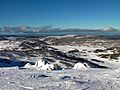
Perisher Valley from Mount Perisher
-
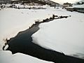
A creek in Perisher
-
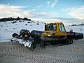
A snow grooming machine in Perisher
-
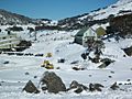
Perisher snow fields
-
Toboggan field at Perisher
-
Looking towards Blue Cow from Perisher
-
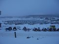
Main carpark at Perisher
-
Blue Cow ski area


