
Perisher Valley, New South Wales facts for kids
Quick facts for kids Perisher Valley |
|
|---|---|

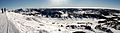
Perisher Valley from Mount Perisher.
|
|

Perisher Valley
Location in New South Wales
|
|
| Floor elevation | 1,720 m (5,640 ft) |
| Geography | |
| Location | Snowy Mountains, New South Wales, Australia |
Perisher Valley, often just called Perisher, is a beautiful valley in the Snowy Mountains of New South Wales, Australia. It sits below Mount Perisher, a tall mountain in the area.
This valley is part of the Snowy Monaro Regional Council. It's also one of the four main areas of the huge Perisher Ski Resort. The other areas are Guthega, Blue Cow, and Smiggin Holes. Perisher Valley is inside Kosciuszko National Park, located between Jindabyne and Charlotte Pass on the Kosciuszko Road. You can get there by car or by the special Skitube Alpine Railway. Even though it's mostly known for winter sports, you can visit all year round. There are places to stay, tours, and fun bush walks.
In 2021, about 99 people lived in Perisher Valley. But in winter, when skiers and snowboarders visit, the population grows to around 2,500 people!
Contents
Perisher Valley Weather and Snow
Perisher Valley has cool summers and very cold winters. It gets a lot of snow that stays on the ground for several months. Sometimes, snow can even last into early summer! On average, it snows about 60 days each year.
| Climate data for Perisher Valley Ski Centre (1991–2010, extremes 1976–2010); 1,735 m (5,692 ft) AMSL; 36.40° S, 148.41° E | |||||||||||||
|---|---|---|---|---|---|---|---|---|---|---|---|---|---|
| Month | Jan | Feb | Mar | Apr | May | Jun | Jul | Aug | Sep | Oct | Nov | Dec | Year |
| Record high °C (°F) | 28.2 (82.8) |
29.8 (85.6) |
25.4 (77.7) |
22.0 (71.6) |
18.0 (64.4) |
14.0 (57.2) |
10.5 (50.9) |
13.5 (56.3) |
16.0 (60.8) |
21.0 (69.8) |
25.5 (77.9) |
25.2 (77.4) |
29.8 (85.6) |
| Mean daily maximum °C (°F) | 19.7 (67.5) |
18.7 (65.7) |
16.1 (61.0) |
12.1 (53.8) |
8.3 (46.9) |
4.2 (39.6) |
2.8 (37.0) |
3.6 (38.5) |
6.1 (43.0) |
10.0 (50.0) |
14.3 (57.7) |
16.1 (61.0) |
11.0 (51.8) |
| Daily mean °C (°F) | 12.8 (55.0) |
12.0 (53.6) |
9.5 (49.1) |
5.9 (42.6) |
3.2 (37.8) |
0.5 (32.9) |
−1.0 (30.2) |
−0.4 (31.3) |
2.1 (35.8) |
5.1 (41.2) |
8.0 (46.4) |
9.8 (49.6) |
5.6 (42.1) |
| Mean daily minimum °C (°F) | 5.9 (42.6) |
5.2 (41.4) |
2.8 (37.0) |
−0.4 (31.3) |
−1.9 (28.6) |
−3.3 (26.1) |
−4.7 (23.5) |
−4.4 (24.1) |
−1.9 (28.6) |
0.1 (32.2) |
1.6 (34.9) |
3.4 (38.1) |
0.2 (32.4) |
| Record low °C (°F) | −5.0 (23.0) |
−7.0 (19.4) |
−7.0 (19.4) |
−10.8 (12.6) |
−9.8 (14.4) |
−18.0 (−0.4) |
−17.0 (1.4) |
−15.0 (5.0) |
−12.5 (9.5) |
−11.6 (11.1) |
−8.5 (16.7) |
−5.9 (21.4) |
−18.0 (−0.4) |
| Average precipitation mm (inches) | 113.9 (4.48) |
88.0 (3.46) |
92.0 (3.62) |
71.0 (2.80) |
104.4 (4.11) |
174.1 (6.85) |
155.6 (6.13) |
243.6 (9.59) |
244.2 (9.61) |
161.2 (6.35) |
152.8 (6.02) |
87.5 (3.44) |
1,689.5 (66.52) |
| Average precipitation days (≥ 0.2 mm) | 8.0 | 8.3 | 8.8 | 8.8 | 10.1 | 12.4 | 12.2 | 12.7 | 13.7 | 12.8 | 11.2 | 6.4 | 125.4 |
| Average afternoon relative humidity (%) | 61 | 65 | 62 | 65 | 73 | 85 | 88 | 84 | 79 | 68 | 61 | 56 | 71 |
| Source: Bureau of Meteorology | |||||||||||||
Snow Depth Measurements
Snow depth is measured at Spencers Creek. This spot is about 2 kilometers (1.2 miles) west of Perisher Valley. These measurements help track how much snow is on the ground.


History of Perisher Valley
The Snowy Mountains have been home to Aboriginal people for about 20,000 years. In summer, different tribes would gather in the high country. They would feast on Bogong moths, which was a big event. This tradition continued until around 1865.
European explorers arrived in the area starting in 1835. In 1840, Edmund Strzelecki climbed Mount Kosciuszko. He named it after a Polish hero. Later, cattle graziers, or stockmen, used the Snowy Mountains to feed their animals in summer. The famous poem The Man From Snowy River by Banjo Paterson tells stories from this time. These stockmen built many small huts across the mountains.
There's a story that the name "Perisher" came from James Spencer. He settled in the area in the 1840s. One day, he was caught in a bad storm and supposedly said, "What a perisher!"
National Park and Skiing Beginnings
The area where Perisher is located became a protected park in 1906. It was first called the National Chase Snowy Mountains. Later, it became the Kosciuszko State Park in 1944. Finally, it was named Kosciuszko National Park in 1967.

Skiing in Australia started around 1861 in Kiandra, further north. But in the 1900s, skiing became popular near Mount Kosciuszko. The first Kosciuszko Chalet was built at Charlotte Pass in 1930. This made it easier for skiers to reach Australia's highest areas. As more skiers came, a cafe opened at Smiggin Holes around 1939. From there, horse-drawn sleighs would take skiers to the Chalet.
The huge Snowy Mountains Hydro-Electric Scheme project, which began in 1949, really opened up the area. It helped develop ski resorts like Thredbo and Perisher. When the Guthega Dam was built, skiers started coming to the isolated Guthega area. A rope tow was even installed there in 1957.
Growth of Perisher Ski Resort
As more and more skiers arrived, services and ways to get around improved. Perisher's first lodges, Telemark and the Snow Revellers Club, were built in 1952. In 1953, the first special vehicle for traveling over snow arrived in Perisher Valley. Everyone cheered and celebrated!

In 1958, Svere Kaaten, a mountain pioneer, built a modern rope tow at North Perisher. His friend, Ken Murray, built another rope tow and Perisher's first T-bar lift. Development continued, and the Mount Perisher Double Chairlift opened in 1962. With these new lifts, the Perisher area grew quickly.
Over the years, different companies took over the resort. In 1995, two big companies merged to form Perisher Blue Pty Limited. This made Perisher even bigger.
The last major ski area to be developed in New South Wales was Mount Blue Cow in the 1980s. In 1987, the Skitube Alpine Railway opened. This special train takes skiers from Bullocks Flat to Perisher Valley and Blue Cow. Blue Cow bought Guthega in 1991. Then, this combined resort joined with Perisher-Smiggins. This created the largest ski resort in the Southern Hemisphere! By 2009, Perisher had 48 lifts and covered 1,245 hectares (about 3,076 acres). It had four main village areas: Perisher Valley, Blue Cow, Smiggin Holes, and Guthega.
Snowy Mountains of Music Festival
Since 2009, Perisher Valley has hosted the Snowy Mountains of Music Festival. This is a folk music festival created by the same people who run the Illawarra Folk Festival. The festival happens every year on the King's Birthday Weekend. This weekend also marks the official start of the ski season in the Snowy Mountains. The festival helps promote the Australian snow season and gives a stage to many Australian and international musicians.
Perisher Resort Facts

Perisher Valley is located 1,720 meters (5,643 feet) above sea level. The top of Mount Perisher, just above the village, reaches 2,054 meters (6,739 feet). The highest point you can reach by ski lift is the Mt Perisher Double Chair, at 2,034 meters (6,673 feet).
According to information from 2012, the natural snow line in the area is at 1,650 meters (5,413 feet). Over the past 15 years, the deepest snow at the resort was about 1.9 meters (6.2 feet) on average. The average lowest temperature during winter was about -3.7°C (25.3°F).
In 2012, the four areas of the Perisher Ski Resort had a total skiable area of 1,245 hectares (3,076 acres). There were 47 ski lifts. This makes Perisher the biggest ski resort in Australia!
Gallery
-
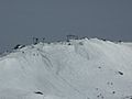
Olympic Ski Trail, leading to Perisher Valley from Back Perisher Mountain
-
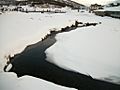
A creek in Perisher
-
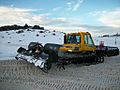
A snow grooming machine in Perisher
-
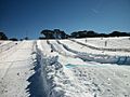
Toboggan field at Perisher
-
Looking towards Blue Cow from Perisher


