Heard Island and McDonald Islands facts for kids
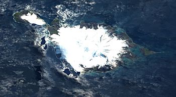
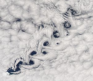
Satellite image of Heard Island.
|
|
 |
|
| Geography | |
|---|---|
| Location | Indian Ocean |
| Major islands | 2 |
| Area | 368 km2 (142 sq mi) |
| Highest elevation | 2,745 m (9,006 ft) |
| Highest point | Mawson Peak |
| Administration | |
| Demographics | |
| Population | Uninhabited (2011) |
| Additional information | |
| Official website | HM Domain Registry |
| UNESCO World Heritage Site | |
| Criteria | Natural: viii, ix |
| Inscription | 1997 (21st Session) |
| Area | 658,903 ha |
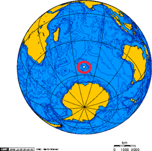
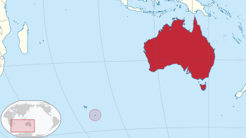
The Territory of Heard Island and McDonald Islands (often called HIMI) is a special Australian territory. It's a group of volcanic islands that are mostly bare and icy, located in the Indian Ocean. They are about two-thirds of the way from Madagascar to Antarctica.
The islands cover an area of about 372 square kilometers (144 sq mi) and have a coastline of 101.9 kilometers (63.3 mi). They were found in the mid-1800s and have been an Australian territory since 1947. HIMI is home to Australia's only two active volcanoes. The top of one, Mawson Peak, is taller than any other mountain in Australia, except for a few in the Australian Antarctic Territory.
These islands are among the most remote places on Earth. They are very far from major landmasses:
- About 4,099 km (2,547 mi) southwest of Perth, Australia.
- About 3,845 km (2,389 mi) southwest of Cape Leeuwin, Australia.
- About 4,200 km (2,600 mi) southeast of South Africa.
- About 3,830 km (2,380 mi) southeast of Madagascar.
- About 1,630 km (1,010 mi) north of Antarctica.
- About 450 km (280 mi) southeast of the Kerguelen Islands.
No one lives on these islands permanently.
Contents
History of the Islands
People didn't visit these islands until the mid-1850s.
Discovery of the Islands
An American sailor named John Heard saw Heard Island on November 25, 1853. He was on his ship Oriental, sailing from Boston to Melbourne. He reported his discovery a month later, and the island was named after him. Six weeks later, on January 4, 1854, William McDonald found the nearby McDonald Islands. He was on his ship Samarang.
Early Visitors and Sealing
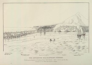
No one landed on the islands until March 1855. Sealers from the ship Corinthian, led by Erasmus Darwin Rogers, went ashore. From 1855 to 1880, many American sealers stayed on the island for a year or more. They lived in very basic huts. At its busiest, about 200 people lived there. By 1880, the sealers had hunted most of the elephant seals, so they left the island. During this time, they collected over 100,000 barrels of elephant-seal oil.
Some shipwrecks have happened near the islands. There's also an old building left from John Heard's sealing station near Atlas Cove.
Becoming Australian Territory
The United Kingdom officially claimed the islands in 1910. They were then given to Australia on December 26, 1947. This was confirmed in letters in 1950. The islands became a World Heritage Site in 1997, recognized for their natural importance.
The first recorded landing on McDonald Island was on February 12, 1971. Australian scientists Grahame Budd and Hugh Thelander landed there using a helicopter.
Exploration and Research
Between 1965 and 2000, at least five private trips went to Heard Island. Many amateur radio operators have also visited, often with scientific groups. They used special callsigns like VK0HI and VK0EK to make radio contacts around the world.
The top of Mawson Peak was first climbed on January 25, 1965. Five members of an expedition called the Southern Indian Ocean Expedition to Heard Island made the climb. An Australian Army team made the third climb in 2000.
In 1991, the islands were used for a special experiment. It was called the Heard Island feasibility test. Scientists tested how far low-frequency sound could travel through the ocean. Signals were sent from US Navy ships and could be heard as far away as the coasts of the US and Canada.
Geography of the Islands
<mapframe text="Heard Island" width=242 height=180 zoom=8 latitude=-53.1 longitude=73.516667/> Heard Island is the biggest island in the group. It's a mountainous island covering 368 square kilometers (142 sq mi). About 80% of the island is covered by 41 glaciers. The island is dominated by the Big Ben mountain. Its highest point is Mawson Peak, which is 2,745 meters (9,006 ft) tall. Mawson Peak is an active volcano. In July 2000, satellite images showed a lava flow from the top of Big Ben.
The McDonald Islands are much smaller and rocky. They are located 44 km (27 mi) west of Heard Island. They include McDonald Island (186 m or 610 ft high), Flat Island (55 m or 180 ft high), and Meyer Rock (170 m or 560 ft high). Together, they are about 2.5 square kilometers (1.0 sq mi) in total area. There's also a small group of rocks north of Heard Island. These include Shag Islet, Sail Rock, Morgan Island, and Black Rock.
Mawson Peak and McDonald Island are the only two active volcanoes in Australian territory. Mawson Peak has erupted several times recently, with the latest eruption filmed in February 2016. The volcano on McDonald Island was quiet for 75,000 years. But it became active in 1992 and has erupted several times since, most recently in 2005.
The islands have no ports or harbors. Ships have to anchor offshore. The coastline is 101.9 km (63.3 mi) long. Australia claims a 12 nautical mile (22 km) territorial sea and a 200 nautical mile (370 km) exclusive fishing zone around them.
Wetlands and Waterways
Heard Island has many small wetland areas along its coast. These include areas with wetland plants, lagoons, rocky shores, and sandy shores like the Elephant Spit. Many of these wetlands are separated by active glaciers. There are also short streams fed by glaciers and glacial pools. Some wetlands were found on McDonald Island, but their current size is unknown due to recent volcanic activity.
The wetlands of HIMI are very important. They are considered for special protection under the Ramsar Convention. This convention protects wetlands that are important for waterfowl.
These wetlands provide important places for many Antarctic and subantarctic animals to breed and feed. These animals include the southern elephant seal and several types of penguins. These penguins are the macaroni, gentoo, king, and eastern rockhopper penguins. Other parts of the islands also have penguin and seabird colonies.
Climate Conditions
The islands have an Antarctic climate. This means the weather is cold, but the ocean makes it a bit milder. The weather usually has small changes in daily and yearly temperatures. There are often low clouds, frequent rain or snow, and strong winds. Snow can fall all year round.
At Atlas Cove, on Heard Island, the average monthly temperatures range from 0.0°C to 4.2°C (32.0°F to 39.6°F). Winds mostly blow from the west and are very strong. Gusts over 180 km/h (110 mph) have been recorded. The islands get a lot of rain or snow, about 1,300 to 1,900 mm (51 to 75 in) each year. It rains or snows about three out of every four days.
| Climate data for Heard Island, 12 m asl (1981–2010 normals) | |||||||||||||
|---|---|---|---|---|---|---|---|---|---|---|---|---|---|
| Month | Jan | Feb | Mar | Apr | May | Jun | Jul | Aug | Sep | Oct | Nov | Dec | Year |
| Record high °C (°F) | 20.1 (68.2) |
18.0 (64.4) |
19.9 (67.8) |
20.4 (68.7) |
19.3 (66.7) |
14.0 (57.2) |
15.0 (59.0) |
15.4 (59.7) |
16.8 (62.2) |
16.4 (61.5) |
14.6 (58.3) |
19.2 (66.6) |
20.4 (68.7) |
| Mean daily maximum °C (°F) | 6.4 (43.5) |
6.5 (43.7) |
6.3 (43.3) |
5.3 (41.5) |
3.7 (38.7) |
2.3 (36.1) |
2.2 (36.0) |
2.2 (36.0) |
2.2 (36.0) |
3.3 (37.9) |
4.1 (39.4) |
5.4 (41.7) |
4.2 (39.5) |
| Daily mean °C (°F) | 4.7 (40.5) |
4.8 (40.6) |
4.6 (40.3) |
3.6 (38.5) |
2.2 (36.0) |
0.9 (33.6) |
0.5 (32.9) |
0.4 (32.7) |
0.5 (32.9) |
1.5 (34.7) |
2.4 (36.3) |
3.8 (38.8) |
2.5 (36.5) |
| Mean daily minimum °C (°F) | 3.0 (37.4) |
3.1 (37.6) |
2.8 (37.0) |
1.9 (35.4) |
0.7 (33.3) |
−0.6 (30.9) |
−1.1 (30.0) |
−1.4 (29.5) |
−1.1 (30.0) |
−0.2 (31.6) |
0.7 (33.3) |
2.1 (35.8) |
0.8 (33.5) |
| Record low °C (°F) | −0.5 (31.1) |
0.2 (32.4) |
−1.7 (28.9) |
−2.9 (26.8) |
−4.8 (23.4) |
−7.2 (19.0) |
−6.2 (20.8) |
−11.5 (11.3) |
−8.6 (16.5) |
−7.1 (19.2) |
−6.2 (20.8) |
−0.7 (30.7) |
−11.5 (11.3) |
| Source 1: Météo climat stats | |||||||||||||
| Source 2: Météo Climat | |||||||||||||
Wildlife of Heard Island and McDonald Islands
The main animals living here are insects, along with many seabirds, seals, and penguins.
Flora: Plant Life
Plant Growth Conditions
The islands are part of a cold region called the Southern Indian Ocean Islands tundra. Because of the cold climate, plants are mostly limited to grasses, lichens, and mosses. There aren't many different types of plants. This is because the islands are isolated, small, and have a harsh climate. Heard Island also has a lot of permanent ice. Strong winds, water, soil, salt spray, and nutrients all affect where plants can grow.
History of Plant Life
Old records show that ferns and woody plants used to grow on Heard Island. This was during a time when the climate was cooler and wetter. These plants are not found there today. However, some plants like the Pringlea antiscorbutica and six moss species might be survivors from that time. Volcano activity has also changed where plants grow. As glaciers melt, new ice-free areas appear. This gives plants more places to spread.
Flowering Plants and Ferns
Small flowering plants and bryophytes (mosses and liverworts) are the main types of plants. Heard Island has the fewest types of vascular plants (plants with tubes for water) compared to other subantarctic islands. This is due to its isolation and cold climate. There are 12 known vascular plant species on Heard Island. Five of these are also on McDonald Island. None of these plants are found only on these islands. However, Pringlea antiscorbutica, Colobanthus kerguelensis, and Poa kerguelensis only grow on subantarctic islands in the southern Indian Ocean.
The plants are typical for this cold region. Heard Island is the largest subantarctic island with no known human-introduced plants. New areas for plants to grow appear as glaciers melt or new land forms from lava flows. Today, a lot of Heard Island, over 20 square kilometers (7.7 sq mi), has plants. These plants grow best in coastal areas below 250 meters (820 ft) in height.
Mosses and Liverworts
Bryophytes, which include mosses and liverworts, add a lot to the plant life on Heard Island. There are 43 types of mosses and 19 types of liverworts. They often grow in places where other plants can't, like on cliff faces. A survey of McDonald Island in 1980 found fewer types of plants there.
Algae and Seaweed
At least 100 types of land algae are known on Heard Island. They often grow in wet places. Forests of giant Antarctic kelp, Durvillaea antarctica, grow in several spots around Heard Island. At least 17 other types of seaweed are also known. There aren't many types of seaweed because the island is isolated. Also, waves and small stones constantly rub against the shore. Glaciers also extend into the sea in many areas.
Plant Communities
Heard Island has different areas where plants grow. Seven main plant communities are recognized:
- Small types of shrubbery, including mosses and liverworts.
- Open cushionfield plants are the most common. They are made of Azorella selago cushions mixed with mosses and small plants. They cover 20–75% of the ground and are found between 30–70m (98–230 ft) high.
- Fellfield areas have a lot of bare ground and less than 50% plant cover. This happens because of harsh weather or newly exposed land from melting ice.
- Mossy fellfield has many different plant types. It includes mosses and small Azorella selago cushions. It's found between 30 and 150 m (98 and 492 ft) high in areas with some protection.
- Wet mixed herbfield grows on wet ground, often near burrowing birds. It has the most plant types. Common plants include Poa cookii, Azorella selago, Pringlea antiscorbutica, Acaena magellanica, and Deschampsia antarctica.
- Coastal biotic plants are mostly Poa cookii and Azorella selago. They grow in coastal areas where seals and seabirds have a big impact.
- Saltspray vegetation is mostly the salt-tolerant moss Muelleriella crassifolia. It grows low down on exposed coastal rocks.
- Closed cushionfield is found on sand and rocks, mostly below 60 m (200 ft). It's almost entirely covered by Azorella selago cushions. These often grow together to form continuous mats.
Future of Plant Life
Heard Island is changing quickly because glaciers are melting and the climate is getting warmer. More land is becoming available for plants to grow. This has led to big changes in the island's plant life in the last 20 years. Other plant species from warmer subantarctic islands might grow here if the climate continues to warm.
Some plant species are spreading and changing the plant communities. These changes are likely to continue and speed up. Changes in seal and seabird numbers might also affect plants. This happens by changing nutrients in the soil and by animals walking on plants.
One plant, Poa annua, is a common grass from Europe. It might have been brought by humans, but it probably arrived naturally. Birds called skuas might have carried its seeds from the Kerguelen Islands. Since 1987, Poa annua has grown more dense and spread to new areas. Human activity might have helped it spread, but wind and animal movement are probably the main reasons.
There's a high chance that new plant species, including invasive ones, could arrive. This is because there are few plant types already there and the climate is getting milder. In 2003/04, a new plant, Cotula plumosa, was found. This plant grows on many subantarctic islands.
Fungi: Lichens
71 types of lichens have been found on Heard Island. They are common on exposed rocks and cover a lot of the ground in some areas. A 1980 survey of McDonald Island found fewer types of lichens there, only eight species.
Fauna: Animal Life
Mammals: Seals
Sealing on Heard Island happened from 1855 to 1910. During this time, 67 sealing ships visited. This hunting caused the seal populations to become very small. Modern sealers visited in the 1920s. Since then, the seal populations have generally grown and are now protected.
Seals that breed on Heard Island include the southern elephant seal, the Antarctic fur seal, and the subantarctic fur seal. Leopard seals visit regularly in winter but do not breed here. Crabeater seals, Ross seals, and Weddell seals visit sometimes.
Birds: Seabirds and Penguins
Heard Island and the McDonald Islands have no introduced predators. This makes them very important breeding places for many birds in the huge Southern Ocean. The waters around the islands are important feeding areas. The islands are recognized as an Important Bird Area because so many seabirds nest there.
Nineteen types of birds have been recorded breeding on Heard Island and the McDonald Islands. However, recent volcanic activity on the McDonald Islands may have reduced nesting areas.
Penguins are by far the most common birds on the islands. Four types breed here: king, gentoo, macaroni, and eastern rockhopper penguins. The penguins mostly nest in the grassy coastal areas of Heard Island. They have also been seen in the flat areas and valleys on McDonald Island.
Other seabirds that breed on Heard Island include three types of albatross (wandering, black-browed, and light-mantled albatrosses). Also, southern giant petrels, Cape petrels, and four types of burrowing petrels breed here. These include Antarctic and Fulmar prions, common and South Georgian diving-petrels. Wilson's storm-petrels, kelp gulls, subantarctic skuas, Antarctic terns, and the Heard shag also breed on the island. The Heard Island subspecies of the black-faced sheathbill also breeds here. Both the shag and the sheathbill are found only on Heard Island.
Another 28 seabird species visit the islands but do not breed there. The number of king penguins on Heard Island has grown a lot since 1947/48. Their population has doubled about every five years for over 50 years.
Invertebrates: Insects and More
Heard Island has fewer types of land invertebrates (animals without backbones) than other Southern Ocean islands. This is like its low plant diversity. The island's isolation and small ice-free area contribute to this. The invertebrate animals are very natural, with few, if any, introduced species.
Two species, a thrips called Apterothrips apteris and a mite called Tyrophagus putrescentiae, are thought to be recent, possibly natural, arrivals. An earthworm species, Dendrodrilus rubidus, was found near Atlas Cove in 1929. It has recently been found in various wet habitats on Heard Island.
The arthropods (insects, spiders, mites) of Heard Island are well-known. There are 54 types of mites and ticks, one spider, and eight springtails. A study in 1987/88 found up to 60,000 springtails per square meter in the soil under Pringlea antiscorbutica plants.
Beetles and flies are the most common insects on Heard Island. About half of the free-living insects live in specific habitats. The rest are found in many different places, like coastal areas, plant stands, mosses, or under rocks. Insect numbers change a lot with the seasons. They are much lower in winter than in summer.
The animals in the freshwater pools, lakes, and streams on Heard Island are similar to those on other subantarctic islands. Many species found on Heard Island are also found elsewhere. The freshwater animals include a type of Protista, a gastrotrich, two types of tardigrades, at least four types of nematodes, 26 types of rotifers, six types of annelids, and 14 types of arthropods.
The marine animals without backbones on Heard Island's rocky shores are also similar to those on other subantarctic islands. The large seaweed Durvillaea antarctica supports many different invertebrate animals. It might also help transport some of these animals to Heard Island.
Retreat of Heard Island Glaciers
Heard Island is a volcanic island in the Southern Ocean with many glaciers. It's about 4,000 km (2,500 mi) southwest of Australia. About 80% of the island is covered in ice. Glaciers flow from 2,400 meters (7,900 ft) down to sea level. Because Heard Island is so steep, most of its glaciers are quite thin, about 55 meters (180 ft) deep on average. Studying these glaciers helps scientists understand how climate change affects ice.
Changes in Glaciers Over Time
Records show that the glaciers didn't change much between 1874 and 1929. But between 1949 and 1954, big changes were seen in the ice formations on Big Ben. This might have been due to volcanic activity. By 1963, most glaciers were clearly shrinking below 2,000 feet (610 m). Some shrinking was even seen as high as 5,000 feet (1,500 m).
The ice cliffs of Brown and Stephenson Glaciers were over 50 feet (15 m) high in 1954. By 1963, they had disappeared. The glaciers ended as much as 100 yards (91 m) inland. Baudissin Glacier on the north coast and Vahsel Glacier on the west coast have lost a lot of ice. Winston Glacier shrank about one mile (1.6 km) between 1947 and 1963. This shows it's a good indicator of glacier change. Jacka Glacier on the east coast has also shrunk a lot since 1955.
Comparing aerial photographs from 1947 and 1980 shows that glacier fronts across Heard Island are retreating. This is most noticeable on the eastern part of the island. Here, glaciers that used to reach the sea are now inland. Glaciers on the northern and western coasts have become much narrower. The ice on Laurens Peninsula has shrunk by 30% to 65%.
Between 1947 and 1988, the total area of Heard Island's glaciers decreased by 11%. It went from 288 square kilometers (111 sq mi) to 257 square kilometers (99 sq mi). A visit in 2000 found that Stephenson, Brown, and Baudissin glaciers had shrunk even more. Brown Glacier's end has moved back about 1.1 km (0.68 mi) since 1950. Its total ice-covered area decreased by about 29% between 1947 and 2004. This amount of ice loss matches the measured temperature increase of 0.9°C (1.6°F) during that time.
Reasons for Glacier Retreat
Possible reasons why glaciers on Heard Island are shrinking include:
- Volcanic activity.
- The Antarctic Convergence moving south. This could cause glaciers to shrink due to warmer sea and air temperatures.
- Overall climate change.
The Australian Antarctic Division had an expedition to Heard Island in 2003–04. Scientists studied birds, land animals, and glaciers. They researched the Brown Glacier to see if its retreat was fast or in steps. They measured the glacier's volume using a special sounder. They also kept monitoring the climate, focusing on how warm Foehn winds affect the glacier.
Based on this expedition, the rate of ice loss on Heard Island seems to be speeding up. Between 2000 and 2003, the rate of ice loss in Brown Glacier was more than double the average rate from 1947 to 2003. This faster ice loss suggests that Heard Island's glaciers are reacting to ongoing climate change. Scientists expect the glaciers to continue retreating in the future.
Administration and Economy
The United Kingdom officially claimed Heard Island in 1910. Australia took over the management of Heard Island and the McDonald Islands on December 26, 1947. This happened when the first Australian National Antarctic Research Expedition (ANARE) arrived. The transfer was confirmed in letters between the two governments in 1950.
The islands are an Australian territory. They are managed from Hobart by the Australian Antarctic Division. This division is part of the Australian Department of the Environment and Energy. The Heard Island and McDonald Islands Act 1953 sets up the territory's administration. It places the islands under the laws of the Australian Capital Territory. The islands are part of a large marine reserve, covering 65,000 square kilometers (25,000 sq mi). They are mainly visited for research. No one lives there permanently.
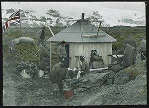
From 1947 to 1955, there were camps for visiting scientists on Heard Island. Later expeditions used a temporary base at Spit Bay in the east.
The only natural resource on the islands is fish. The Australian government allows limited fishing in the waters around them. Even though no one lives there, the islands have their own country code, HM, in ISO 3166-1. This means they have their own Internet top-level domain, .hm. The time zone for the islands is UTC+5.
See also
 In Spanish: Territorio de las Islas Heard y McDonald para niños
- Australian Antarctic Territory
- List of Antarctic and sub-Antarctic islands
- List of birds of Heard and McDonald Islands
- List of glaciers in the Antarctic
- List of islands of Australia
- Needle Island
- Retreat of glaciers since 1850
- Sunken Rock
- Wakefield Reef
 | William L. Dawson |
 | W. E. B. Du Bois |
 | Harry Belafonte |


