
Australian Capital Territory facts for kids
Quick facts for kids
Australian Capital Territory
|
|||
|---|---|---|---|
|
|||
Nicknames:
|
|||
| Motto:
For the King, the Law, and the People
|
|||
|
Location of ACT in Australia
35°18′29″S 149°07′28″E / 35.30806°S 149.12444°E |
|||
| Country | Australia | ||
| Transferred to Commonwealth | 1 January 1911 | ||
| Responsible government | 1988 | ||
| Largest city | Canberra | ||
| Government | |||
| Andrew Barr (ALP) | |||
| Legislature | Australian Capital Territory Legislative Assembly | ||
| Parliament of Australia | |||
|
• Senate
|
2 senators (of 76) | ||
| 3 seats (of 151) | |||
| Area | |||
|
• Total
|
2,358 km2 (910 sq mi) (8th) | ||
|
• Land
|
2,358 km2 (910 sq mi) | ||
|
• Water
|
0 km2 (0 sq mi) | ||
| Highest elevation | 1,912 m (6,273 ft) | ||
| Lowest elevation | 429 m (1,407 ft) | ||
| Population | |||
|
• March 2022 estimate
|
455,869 (7th) | ||
|
• Density
|
190/km2 (492.1/sq mi) (1st) | ||
| GDP (nominal) | 2022 estimate | ||
|
• Total
|
AU$45.318 billion (6th) | ||
|
• Per capita
|
AU$102,334 (3rd) | ||
| HDI (2021) | very high · 1st |
||
| Time zone | UTC+10:00 (AEST) | ||
|
• Summer (DST)
|
UTC+11:00 (AEDT) | ||
| Postal abbreviation |
ACT
|
||
| ISO 3166 code | AU–ACT | ||
| Symbols | |||
| Mammal | Southern brush-tailed rock-wallaby | ||
| Bird | Gang-gang cockatoo | ||
| Flower | Royal bluebell | ||
| Colour | Blue and gold | ||


The Australian Capital Territory (ACT) is a special area in Australia. It was known as the Federal Capital Territory (FCT) until 1938. This territory is where Canberra, the capital city of Australia, is located. Canberra is the main city in the ACT.
The ACT is in southeastern Australian mainland. It's completely surrounded by the state of New South Wales. It was created after Australia became a country (Federation) to be the seat of government for the new nation. This means it's home to all the important buildings and offices of the Australian Government.
On 1 January 1901, the different parts of Australia joined together to form one country. The new Australian Constitution said that a piece of land in New South Wales, at least 100 miles (160 km) from Sydney, would be given to the new federal government. After looking at many places, the Seat of Government Act 1908 was passed in 1908. It chose the Yass-Canberra area for the capital. The land was given to the federal government in 1911. Two years later, in 1913, the capital city was officially named Canberra.
Most people in the ACT live in Canberra in the north-east. But there are also smaller towns like Williamsdale, Oaks Estate, Uriarra, Tharwa and Hall. The ACT also includes the Namadgi National Park, which covers most of the territory's land. The ACT has a dry climate with warm to hot summers and cool to cold winters.
The Australian Capital Territory is home to many important government buildings, national monuments, and museums. These include the Parliament of Australia, the High Court of Australia, the Australian Defence Force Academy, and the Australian War Memorial. Many foreign embassies (offices for other countries) are also located here. Several major universities have campuses in the ACT, such as the Australian National University and the University of Canberra.
A local government, the legislative assembly, has managed the territory since 1988. However, the Australian Government still has power over the ACT and can change local laws. It also controls the Parliamentary Triangle area through the National Capital Authority. People living in the ACT vote for three members in the House of Representatives and two senators.
The ACT has about 453,324 residents, making it the second smallest mainland state or territory by population. In 2016, the average weekly income for people over 15 was $998, which was much higher than the national average. More people in the ACT have university degrees compared to the rest of Australia. In 2021, the ACT had a very high Human Development Index score (0.980), showing a high quality of life.
Contents
Discovering the ACT's Past
First Peoples of the ACT
Aboriginal Australian people have lived in this area for a very long time. Evidence shows they have been here for at least 25,000 years. The main group living in the region were the Ngunnawal people. Other groups like the Ngarigo and Walgalu lived nearby.
European Arrival and Settlement
After Europeans settled in Australia, there was a need for more farming land. Explorers like Charles Throsby and Allan Cunningham explored the Canberra area in the 1820s. They found that the land was good for grazing animals.
The first land grant in the region was given to Joshua John Moore in 1823. European settlement began in 1824. Moore bought the land in 1826 and named his property Canberry or Canberra. Over time, towns like Ginninderra and Tharwa grew to support the local farming communities. Sadly, contact between settlers and Aboriginal people was limited, and many Aboriginal people were forced to leave their traditional ways of life.
Choosing Australia's Capital

When Australia became a country in 1901, the Australian Constitution said a new capital city was needed. This capital had to be in New South Wales but not too close to Sydney.
After much discussion, the Yass-Canberra region was chosen. Government surveyor Charles Scrivener mapped out the exact location in 1908. He made sure the borders would provide enough water for the new capital.
The Australian Capital Territory officially became part of the Commonwealth of Australia on 1 January 1911. Canberra was named the national capital on 20 March 1913.
Building the Capital City

In 1911, an international competition was held to design the future capital. An American architect named Walter Burley Griffin won in 1912. Construction of Canberra began right away after its naming in 1913.
Over the years, different groups helped plan and build Canberra. A major project was the creation of Lake Burley Griffin. This lake, a central part of Griffin's design, was finished in 1964. Its completion helped shape the city we see today.
Exploring the ACT's Landscape
Size and Location

The Australian Capital Territory is the smallest mainland territory in Australia. It covers about 2,280 square kilometers. This is a bit smaller than the country of Luxembourg.
The ACT's borders were chosen to make sure the capital had a good water supply. The city area of Canberra is in the north-eastern part of the territory.
Towns and Natural Areas
The ACT includes the city of Canberra and smaller towns like Williamsdale, Oaks Estate, Uriarra Village, Tharwa, and Hall. It also has farmland for sheep, dairy cows, and vineyards. A large part of the territory is covered by the Namadgi National Park, which has mountains and forests.

To the south-west of Canberra is Tidbinbilla. Here you can find the Tidbinbilla Nature Reserve and the Canberra Deep Space Communication Complex. This complex is run by NASA and helps communicate with spacecraft in deep space. The territory also has many mountains, rivers, and creeks, mostly within Namadgi National Park.
ACT's Climate

The ACT has a dry climate. Summers are warm to hot, and winters are cool to cold. January is usually the hottest month, with an average high of 27.7°C. July is the coldest, with an average high of 11.2°C. The highest temperature ever recorded was 44.0°C in January 2020. The lowest was -10.0°C in July 1971.
Rainfall changes across the territory. The mountains to the west of Canberra get more rain. Snow is rare in Canberra's city center, but the surrounding mountains get snow every winter.
Nature in the ACT
Plants and Animals
The ACT has many different environments, from high mountains to forests and woodlands. Much of the land has been used for grazing or affected by bushfires.
The native forests are mostly eucalypt trees. These trees were used for fuel and building. Today, there are also many pine plantations. These help prevent soil erosion and are popular places for outdoor activities.
The ACT is home to many Australian animals. You can find kangaroos, wallabies, koalas, platypus, echidnas, emus, kookaburras, and different types of lizards.
People of the ACT
Population and Diversity


As of December 2021, about 453,324 people live in the ACT. Most of them live in Canberra. The population is expected to grow to about 700,000 by 2058.
The ACT is a diverse place. In 2021, about 32.5% of people were born outside Australia. The most common countries of birth for these residents were India, England, China, Nepal, and New Zealand. About 2% of the population identified as Indigenous Australians (Aboriginal Australians and Torres Strait Islanders).
Languages and Beliefs
In 2021, most people (71.3%) in the ACT spoke only English at home. Other common languages included Mandarin, Nepali, Vietnamese, Punjabi, and Hindi.
When it comes to religion, many people (43.5%) said they had no religion in 2021. The most common religions were Catholic (19.3%), Anglican (8.2%), and Hinduism (4.5%).
Cities and Suburbs


The ACT includes Canberra and several smaller towns. Canberra's urban areas are organized into districts, town centers, and suburbs. There are seven main districts, with an eighth one being built. Each district has smaller suburbs and a town center for shops and activities.
The districts were settled over time:
- North Canberra: Settled mostly in the 1920s and 30s.
- South Canberra: Settled from the 1920s to 60s.
- Woden Valley: First settled in 1963.
- Belconnen: First settled in 1967.
- Weston Creek: Settled in 1969.
- Tuggeranong: Settled in 1974.
- Gungahlin: Settled in the early 1990s.
- Molonglo Valley: New suburbs are currently being built here.
The North and South Canberra areas were designed by Walter Burley Griffin. Later, the "Y Plan" was adopted in 1967. This plan shaped how future urban areas would develop, with town centers linked by major roads, forming a "Y" shape.
Culture and Life in the ACT
Education and Learning

Most schools and universities in the ACT are in Canberra. The public school system has Pre-School, Primary School (Kindergarten to Year 6), High School (Years 7-10), and College (Years 11-12). Children must attend school until they are 17.
In 2004, there were 140 schools in the ACT. About 60% of students attended government schools. The two main universities are the Australian National University (ANU) and the University of Canberra (UC). There are also other university campuses and vocational training centers like the Canberra Institute of Technology (CIT).
The Australian Defence Force Academy (ADFA) and the Royal Military College, Duntroon (RMC) are also in Canberra. ADFA offers university degrees for military students, and Duntroon trains Australian Army officers.
Sports and Recreation
The ACT has several professional sports teams. These include the ACT Brumbies (Rugby Union), Canberra United (Soccer), Canberra Raiders (Rugby League), and the Canberra Capitals (Basketball).
The Prime Minister's XI cricket match is played every year at Manuka Oval against a visiting international team. The Greater Western Sydney Giants (Australian Rules Football) also play some of their games in Canberra.
Arts and Entertainment


The territory is home to many important national places and buildings. These include the Australian War Memorial, the National Gallery of Australia, the National Portrait Gallery, the National Library, and the National Museum. Many government buildings, like Parliament House, are open to the public.
Lake Burley Griffin has the Captain James Cook Memorial and the National Carillon (a musical bell tower). Other interesting places are the Telstra Tower, the Australian National Botanic Gardens, the National Zoo and Aquarium, and Questacon – the National Science and Technology Centre.

The Canberra Museum and Gallery shows local history and art. You can also visit historic homes like Lanyon and Calthorpes' House to see how early settlers lived.
The ACT has many places for live music and theatre, such as the Canberra Theatre and Playhouse and Llewellyn Hall. There are also many bars and nightclubs with live entertainment. Popular events include the National Folk Festival, the Royal Canberra Show, and the National Multicultural Festival.
Media and News
The ACT has its own daily newspaper, The Canberra Times, which started in 1926. There are also free weekly magazines. Major newspapers from Sydney and Melbourne are also available.
Many radio stations broadcast in the ACT, including commercial stations and those from the Australian Broadcasting Corporation. There are also five free-to-air television stations, offering a variety of channels.
Getting Around and Services
Transport Options


Most people in the ACT use cars to get around. The city is designed with main roads connecting different areas, often passing through open land. This helps keep traffic flowing.
ACTION, the government bus service, provides public transport throughout the ACT. A light rail line opened in April 2019, connecting the city center with Gungahlin. In 2016, about 7.1% of people used public transport for their commute.
There are also taxi services and ride-sharing services like Uber.
An interstate train service connects Canberra to Sydney from Canberra's railway station in Kingston. Bus services connect to trains for Melbourne.
Canberra is about a three-hour drive from Sydney and a seven-hour drive from Melbourne. It's also a two-hour drive to the Snowy Mountains for skiing or to Batemans Bay on the coast.
Canberra Airport has direct flights to major Australian cities like Sydney, Melbourne, and Brisbane. It also has direct international flights to Singapore and Doha, with a stopover in Sydney.
Utilities and Services

The government-owned Icon Water manages the ACT's water and sewerage systems. ActewAGL provides water, natural gas, and electricity services.
The ACT gets its water from four reservoirs: Corin, Bendora, and Cotter dams on the Cotter River, and Googong Dam on the Queanbeyan River.
Electricity for the ACT mostly comes from the national power grid. The ACT also has four solar farms that opened between 2014 and 2017. Many homes in Canberra also have solar panels. The ACT has a very high rate of homes with internet access.
ACT's Economy
The ACT's economy is mainly focused on Canberra. It has a stable housing market, steady jobs, and a growing population. This has led to a strong economy. In 2016, the ACT was ranked the third best-performing economic region in Australia.
In 2017–18, the ACT had the fastest economic growth in the country. This was due to population growth, a strong higher education sector, and investments in housing and infrastructure.
Higher education is the ACT's biggest export industry. The territory has many universities and education providers. Other major exports include government services and tourism.
The ACT's economy relies a lot on the public sector, with 30% of jobs being in government. Decisions made by the federal government can have a big impact on the ACT's economy.
In 2017–18, the ACT's total economic output was $39.8 billion. This was 2.2% of Australia's total economy.
Images for kids
-
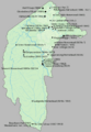
Significant homesteads, structures and settlements in the ACT prior to 1909.

See also
 In Spanish: Territorio de la Capital Australiana para niños
