
Namadgi National Park facts for kids
Quick facts for kids Namadgi National ParkAustralian Capital Territory |
|
|---|---|
|
IUCN Category II (National Park)
|
|

View from the top of the Mount Ginini
|
|

Namadgi National Park
Location in Australian Capital Territory
|
|
| Nearest town or city | Canberra |
| Established | 1984 |
| Area | 1,060.95 km2 (409.6 sq mi) |
| Managing authorities | ACT Parks and Conservation Service |
| Website | Namadgi National Park |
| See also | Australian Capital Territory protected areas |
Namadgi National Park is a special protected area in the southwest of the Australian Capital Territory (ACT). It's right next to Kosciuszko National Park in New South Wales. This park is about 40 kilometers (25 miles) southwest of Canberra. It covers almost half of the ACT's land!
The park protects a part of the beautiful Australian Alps, with amazing granite mountains. You'll find everything from grassy plains to snow gum forests and high mountain meadows here. Lots of animals live here too, like eastern grey kangaroos, wallabies, wombats, magpies, and colorful rosellas. This park is super important because it provides about 85% of Canberra's drinking water!
The weather can change fast, from chilly winter nights to warm summer days. Snow often falls on the Bimberi and Brindabella Ranges in winter. The tallest mountain is Bimberi Peak, standing at 1911 meters (6270 feet). This is the highest peak in the Australian Capital Territory. Namadgi National Park is a Category II protected area. This means it's a national park managed mainly for protecting ecosystems and for recreation.
In January 2020, a large bushfire called the Orroral Valley fire burned about 80% of the park. This was during the big Black Summer bushfires. About 82,700 hectares (204,000 acres) of the park were affected.
Contents
Traditional Owners of the Land

The word Namadgi is an Aboriginal name for the mountains near Canberra. Aboriginal people have lived in this area for at least 21,000 years. There are many ancient Aboriginal sites in the park. This includes paintings at Yankee Hat, which are at least 800 years old.
The area is very important to the Indigenous Australian people of the Australian Alps region. This includes the Nyamudy/Namadgi people, who lived in the ACT region before European settlers arrived. The park's management plan is created with their help and advice.
In 2001, the Ngambri communities and the ACT government made an agreement. This agreement recognized the Ngambri people's connection to the park lands. It also recognized their role as custodians (caretakers) of the area for their ancestors and future generations. This agreement set up a way for them to work together to manage the park.
Europeans started settling in this area in the 1830s. They cleared valleys for farming, but the mountains stayed forested. Namadgi National Park was officially created in 1984. You can find the Visitor Centre about 2 kilometers (1.2 miles) south of Tharwa.
Winter Fun and Skiing
Skiing in the Australian Capital Territory
Namadgi National Park has a history with skiing and snow sports. In the 1930s, people from Canberra wanted to develop skiing in the Brindabella mountains. The Canberra Alpine Club was formed, and they had about 80 members. They hoped to make the Canberra ranges as popular for skiing as Mount Kosciuszko.
In 1938, the Mount Franklin chalet was built at Mount Franklin for the Canberra Alpine Club. They cleared ski runs and even made their own ski lifts. The club also cleared new ski runs on nearby Mount Ginini in 1951. People thought Mount Ginini had better slopes.
The Mount Franklin Chalet became a museum after Namadgi National Park was created in 1984. Sadly, it was destroyed in the 2003 bushfires. A new shelter was built in 2008. Today, you can still enjoy cross-country skiing in the park when there's enough snow.
Australian National Heritage List
On November 7, 2008, Namadgi National Park was added to the Australian National Heritage List. It was listed along with ten other protected areas. These areas are all part of the Australian Alps National Parks and Reserves.

Gallery
-
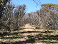
Namadgi National Park walking trail
-
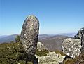
View from the top of the Mount Ginini
-
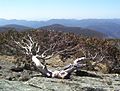
Eucalyptus pauciflora subsp. niphophila
-
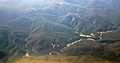
Aerial view of Corin Dam


See also
 In Spanish: Parque nacional Namadgi para niños
