
Brindabella Range facts for kids
Quick facts for kids Brindabella Range |
|
|---|---|
| The Brindabellas | |

Mount Ginini, part of the Brindabellas, in the ACT.
|
|
| Highest point | |
| Peak | Bimberi Peak |
| Elevation | 1,913 m (6,276 ft) AHD |
| Dimensions | |
| Length | 100 km (62 mi) N-S |
| Width | 5 km (3.1 mi) E-W |
| Geography | |

Location in Australian Capital Territory
|
|
| Country | Australia |
| Range coordinates | 35°33′S 148°46′E / 35.550°S 148.767°E |
The Brindabella Range, often called The Brindabellas, is a group of mountains in Australia. It sits right on the border between New South Wales (NSW) and the Australian Capital Territory (ACT). These mountains are west of Canberra, which is Australia's capital city.
The Brindabellas include important natural areas. These are the Namadgi National Park in the ACT. They also include the Bimberi Nature Reserve and Brindabella National Park in NSW. You can easily see the Brindabellas from Canberra. They are a big and beautiful part of the city's view.
Contents
Where are the Brindabellas and what are they like?
The Brindabella Range is at the northern end of the Australian Alps. It forms a natural border with other areas. The range starts at Mount Coree, about 34 kilometers (21 miles) west of Canberra. From there, it stretches south. It follows the western edge of the ACT border with NSW. The very southern tip is at Bimberi Gap. Other nearby ranges include the Bag Range and Scabby Range.
The mountains are made of old rocks like granite and metamorphic rock. These rocks were formed a very long time ago. You can also find small areas of younger basalt rock. The Brindabellas have high, flat areas with steep sides. They also have deep river valleys with amazing gorges and waterfalls. The soil changes depending on how high up you are. In lower forests, the soil is different from the deep, rich soil found in higher, snowier areas.
The plants in the Brindabellas also change with height and weather. Lower, drier areas have trees like red stringybark and white gum. Moist areas have alpine ash and mountain gum. You can also find tree ferns and sassafras in wet gullies. Between 1,000 and 1,500 meters (3,280-4,920 feet), alpine ash trees are common. Higher up, from 1,500 to 1,800 meters (4,920-5,900 feet), you'll see snow gum woodlands. There are also open areas with heath, grasslands, and bogs. Above 1,800 meters (5,900 feet), where trees can't grow, you'll find special alpine plants. These include prickly snow grass and silver snow daisy.
Highest Mountains in the Range
Some of the tallest mountains in the Brindabella Range are:
- Mount Gingera at 1,857 meters (6,093 feet)
- Mount Ginini at 1,762 meters (5,781 feet)
- Mount Franklin at 1,646 meters (5,400 feet)
- Mount Aggie at 1,421 meters (4,662 feet)
- Mount Coree at 1,421 meters (4,662 feet)
Nature Parks and Reserves
The Brindabella Range is home to several important natural areas. These include the Brindabella National Park and Kosciuszko National Park in New South Wales. It also includes the Namadgi National Park in the ACT. Together, these parks cover about 213.6 square kilometers (82.5 square miles).
The Brindabella Valley is in the middle of the range. It is about 40 kilometers (25 miles) southwest of Canberra. The Goodradigbee River flows through this valley.
History of the Brindabellas
The original owners of the Brindabella Range land are the Ngunnawal, Walgalu, and Djimantan peoples. These are all Aboriginal Australian groups. They have lived on this land for thousands of years.
European settlers first came to the Brindabella Valley in the 1830s. They used it as a place to keep livestock. Gold was discovered there in 1860. Mining for gold began in the 1880s and continued until 1910. Today, the valley is used for farming, mostly cattle. The historic Brindabella Station is located here. This was the childhood home of Miles Franklin, a famous Australian writer from the early 1900s.
Miles Franklin wrote a book called Childhood at Brindabella. It tells the story of her early life in the valley.
What does "Brindabella" mean?
The name Brindabella might mean "two kangaroo rats" in an Aboriginal language. However, another idea is that "Brindy brindy" was a local word for water running over rocks. Europeans might have added "bella" from the Italian bella vista, meaning "beautiful view".
Snow in the Brindabellas

The Brindabella Range is one of the few places in Australia that gets snow. It has some of the most northern ski areas in the country. These areas are in Namadgi National Park (ACT) and Bimberi Nature Reserve and Brindabella National Park (NSW). Bimberi Peak is the highest mountain in the ACT. It is 1,912 meters (6,273 feet) tall and is often covered in snow.
In 1938, a ski chalet was built at Mount Franklin. This was for the Canberra Alpine Club. Ski runs were cleared, and simple ski lifts were made. The chalet later became a museum. Sadly, it was destroyed in the 2003 Canberra bushfires. A new shelter was built in 2008. Today, you can go cross-country skiing in the area when there is enough snow. Mount Gingera, which is 1,857 meters (6,093 feet) high, is also a popular spot for cross-country skiing. It is often seen covered in snow from Canberra.
You can also enjoy snow play at Corin Forest, near Canberra. This area is about 1,200 meters (3,937 feet) high. There are plans to add chairlifts, snowmaking machines, and places to stay at Corin Forest in the future.
Weather in the Brindabellas
The weather in the Brindabella Range changes a lot with the seasons. Summers are mild, and winters are cold with snow.
| Climate data for Mount Ginini AWS (2004–) | |||||||||||||
|---|---|---|---|---|---|---|---|---|---|---|---|---|---|
| Month | Jan | Feb | Mar | Apr | May | Jun | Jul | Aug | Sep | Oct | Nov | Dec | Year |
| Record high °C (°F) | 31.1 (88.0) |
30.2 (86.4) |
25.8 (78.4) |
22.4 (72.3) |
16.0 (60.8) |
12.6 (54.7) |
10.2 (50.4) |
16.0 (60.8) |
19.9 (67.8) |
23.3 (73.9) |
27.8 (82.0) |
29.0 (84.2) |
31.1 (88.0) |
| Mean daily maximum °C (°F) | 20.8 (69.4) |
18.9 (66.0) |
16.4 (61.5) |
11.9 (53.4) |
7.7 (45.9) |
3.9 (39.0) |
2.4 (36.3) |
4.1 (39.4) |
8.5 (47.3) |
12.8 (55.0) |
15.7 (60.3) |
17.8 (64.0) |
11.7 (53.1) |
| Mean daily minimum °C (°F) | 10.0 (50.0) |
9.0 (48.2) |
7.3 (45.1) |
4.0 (39.2) |
1.1 (34.0) |
−1.0 (30.2) |
−2.5 (27.5) |
−2.0 (28.4) |
0.3 (32.5) |
2.9 (37.2) |
5.9 (42.6) |
7.3 (45.1) |
3.5 (38.3) |
| Record low °C (°F) | −1.3 (29.7) |
−2.0 (28.4) |
−2.0 (28.4) |
−5.0 (23.0) |
−6.4 (20.5) |
−8.5 (16.7) |
−8.0 (17.6) |
−8.2 (17.2) |
−6.6 (20.1) |
−5.5 (22.1) |
−6.0 (21.2) |
−4.0 (24.8) |
−8.5 (16.7) |
| Average precipitation mm (inches) | 74.5 (2.93) |
94.4 (3.72) |
78.8 (3.10) |
59.9 (2.36) |
57.1 (2.25) |
86.8 (3.42) |
101.9 (4.01) |
88.5 (3.48) |
90.5 (3.56) |
72.8 (2.87) |
108.9 (4.29) |
107.9 (4.25) |
1,051.2 (41.39) |
| Average precipitation days | 10.9 | 12.7 | 12.0 | 9.9 | 10.0 | 12.1 | 16.4 | 13.6 | 11.8 | 10.2 | 12.2 | 12.4 | 144.2 |
Images for kids
-
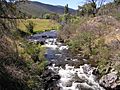
Goodradigbee River in the Brindabella valley.
-
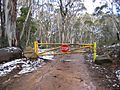
The road to Mount Franklin, ACT, was built by the Canberra Alpine Club in the 1930s.


See also
 In Spanish: Cordillera de Brindabella para niños
