Mount Ginini facts for kids
Quick facts for kids Mount Ginini |
|
|---|---|

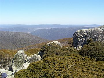
View from Mount Ginini
|
|
| Highest point | |
| Elevation | 1,762 m (5,781 ft) |
| Prominence | 202 m (663 ft) |
| Geography | |
| Location | Australian Capital Territory / New South Wales, Australia |
| Parent range | Brindabella Ranges |
Mount Ginini is a cool mountain that stands tall at 1,762 meters (about 5,781 feet). It's part of the Brindabella Ranges. This mountain sits right on the edge between the Australian Capital Territory (ACT) and New South Wales (NSW) in Australia.
Where is Mount Ginini?
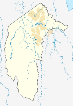
The very top of Mount Ginini is in the Australian Capital Territory (ACT). It's actually the third tallest mountain in the ACT!
Parts of the mountain are inside special protected areas. In the ACT, you'll find it in Bimberi Nature Reserve and Namadgi National Park. The part in New South Wales is in Kosciuszko National Park.
Many people who love hiking enjoy climbing Mount Ginini. They often start their journey from Corin Dam. It's a hike that takes a few hours. Close to the mountain, there's a special place called the Ginini Flats Wetlands Ramsar Site. These wetlands are important for nature.
What's on the Mountain?
Mount Ginini is home to some important equipment. Airservices Australia has an installation there. This helps air traffic controllers (ATCs) talk to airplanes. It's part of a bigger network called AERIES.
The mountain also has a repeater station. This helps the local amateur radio club communicate over longer distances. You can find the main transmitter tower at these coordinates: 35°31′46.61″S 148°46′21.06″E / 35.5296139°S 148.7725167°E.
Mount Ginini's Weather
Mount Ginini has a type of weather called a subpolar oceanic climate. This means it has mild summers and cold winters.
| Climate data for Mount Ginini AWS (2004–) | |||||||||||||
|---|---|---|---|---|---|---|---|---|---|---|---|---|---|
| Month | Jan | Feb | Mar | Apr | May | Jun | Jul | Aug | Sep | Oct | Nov | Dec | Year |
| Record high °C (°F) | 33.2 (91.8) |
30.2 (86.4) |
25.8 (78.4) |
22.4 (72.3) |
16.0 (60.8) |
12.6 (54.7) |
10.2 (50.4) |
16.0 (60.8) |
19.9 (67.8) |
23.3 (73.9) |
27.8 (82.0) |
29.0 (84.2) |
33.2 (91.8) |
| Mean daily maximum °C (°F) | 20.8 (69.4) |
18.9 (66.0) |
16.4 (61.5) |
11.9 (53.4) |
7.7 (45.9) |
3.9 (39.0) |
2.4 (36.3) |
4.1 (39.4) |
8.5 (47.3) |
12.8 (55.0) |
15.7 (60.3) |
17.8 (64.0) |
11.7 (53.1) |
| Mean daily minimum °C (°F) | 10.0 (50.0) |
9.0 (48.2) |
7.3 (45.1) |
4.0 (39.2) |
1.1 (34.0) |
−1.0 (30.2) |
−2.5 (27.5) |
−2.0 (28.4) |
0.3 (32.5) |
2.9 (37.2) |
5.9 (42.6) |
7.3 (45.1) |
3.5 (38.3) |
| Record low °C (°F) | −1.3 (29.7) |
−2.0 (28.4) |
−2.0 (28.4) |
−5.0 (23.0) |
−6.4 (20.5) |
−8.5 (16.7) |
−8.0 (17.6) |
−8.2 (17.2) |
−6.6 (20.1) |
−5.5 (22.1) |
−6.0 (21.2) |
−4.0 (24.8) |
−8.5 (16.7) |
| Average precipitation mm (inches) | 74.5 (2.93) |
94.4 (3.72) |
78.8 (3.10) |
59.9 (2.36) |
57.1 (2.25) |
86.8 (3.42) |
101.9 (4.01) |
88.5 (3.48) |
90.5 (3.56) |
72.8 (2.87) |
108.9 (4.29) |
107.9 (4.25) |
1,051.2 (41.39) |
| Average precipitation days | 10.9 | 12.7 | 12.0 | 9.9 | 10.0 | 12.1 | 16.4 | 13.6 | 11.8 | 10.2 | 12.2 | 12.4 | 144.2 |
 | Dorothy Vaughan |
 | Charles Henry Turner |
 | Hildrus Poindexter |
 | Henry Cecil McBay |


