Cotter River facts for kids
Quick facts for kids Cotter |
|
|---|---|

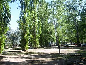
Confluence of the Cotter River with the Murrumbidgee River, 2007
|
|

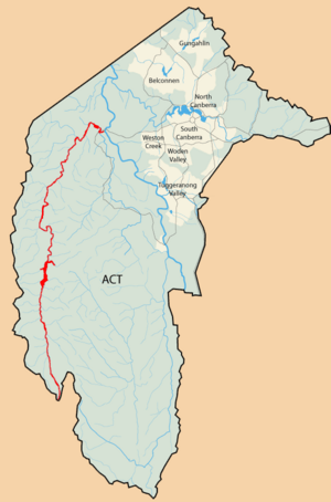
Map of the Australian Capital Territory, with the Cotter River marked in red
|
|
| Country | Australia |
| Territory | Australian Capital Territory |
| Region | South Eastern Highlands (IBRA), Capital Country |
| Physical characteristics | |
| Main source | Scabby Range, Brindabella Ranges below Mount Scabby 1,760 m (5,770 ft) 35°44′25″S 148°50′21″E / 35.74028°S 148.83917°E |
| River mouth | confluence with the Murrumbidgee River Casuarina Sands 466 m (1,529 ft) 35°19′27″S 148°57′1″E / 35.32417°S 148.95028°E |
| Length | 76 km (47 mi) |
| Basin features | |
| River system | Murrumbidgee River, Murray-Darling basin |
| Basin size | 480.1 km2 (185.4 sq mi) |
| Tributaries |
|
| Reservoirs | Corin, Bendora and Cotter dams |
The Cotter River is an important river in the Australian Capital Territory (ACT), Australia. It's a "perennial river," meaning it flows all year round. The Cotter River is part of the larger Murrumbidgee River system, which then flows into the huge Murray-Darling Basin. Along with the Queanbeyan River, the Cotter River provides clean drinking water for the cities of Canberra and Queanbeyan.
Contents
Where Does the Cotter River Flow?
The Cotter River starts high up in the Brindabella Ranges. This is in the south-west part of the ACT, inside Namadgi National Park. The river then flows mostly north. It is joined by six smaller streams, called tributaries. One of these is Paddys River.
The Cotter River eventually meets the Murrumbidgee River. This meeting point is called a confluence. It's near a place called Casuarina Sands, west of the suburb of Weston Creek. The river drops about 1,300 meters (4,265 feet) over its 76-kilometer (47-mile) course.
Who Named the Cotter River?
The land around the Cotter River has always belonged to the Aboriginal people. Specifically, it is the traditional country of the Ngunnawal clan.
The river was named after Garrett Cotter. He was born in Ireland and was sent to Australia as a convict. This meant he was transported for a crime and had to live in Australia. In 1832, Cotter was moved to the western side of the Murrumbidgee River. He built a house near where the river starts, which later got his name.
Garrett Cotter eventually gained more freedom. He received a "ticket-of-leave" in 1843. This allowed him to work for himself. In 1846, he got a "conditional pardon," meaning he was free to move around, except in Britain and Ireland. He later lived in Michelago.
When Charles Scrivener was surveying the land for Australia's new capital, Canberra, he looked for good water catchment areas. A water catchment is an area where rainfall collects and drains into a river. About 480 square kilometers (185 square miles) of the ACT were set aside. This area became the catchment for the Cotter River. This was planned to provide water for a city of 100,000 people.
How Do Dams Help the Cotter River?
There are three large reservoirs built on the Cotter River. These are the Corin, Bendora, and Cotter Dams. Together, they form the Cotter River System. This system supplies most of the drinking water to Canberra. Most of the Cotter catchment area is protected within the Namadgi National Park.
Fun Things to Do at the Cotter River
The Cotter Dam and its reservoirs provide drinking water. Because of this, you cannot use boats or other watercraft on them. However, the Cotter River Reserve is a very popular spot. It's located at the base of the dam wall.
This reserve is a great place for a picnic. It has barbecue facilities and tables. There are also areas where you can go swimming when the river has enough water. There's even a small camping site for tents and caravans.
The Cotter Road is a scenic drive, also known as ACT tourist route 5. It starts in Canberra and stretches about 17.6 kilometers (11 miles). It passes by suburbs like Curtin and Duffy. It goes through beautiful areas like Stromlo Forest and past Casuarina Sands. The Cotter Road and the nearby Brindabella Road are popular with motorcyclists. They enjoy riding there on weekends.
The upper part of the Cotter River is also popular for white water kayaking. It has a fast-flowing section that is rated as "grade 3." This means it's exciting but needs good skills. However, the river needs a lot of rain to have enough water for kayaking. There are also kayaking spots below the dam. Near the main picnic area, there's a "Cotter Play Wave." This is a small weir that creates a fun wave for "playboating." From this spot, you can paddle all the way to the Murrumbidgee River. Always be careful of trees and other objects in the water.
 | Delilah Pierce |
 | Gordon Parks |
 | Augusta Savage |
 | Charles Ethan Porter |


