South Eastern Highlands facts for kids
Quick facts for kids South Eastern HighlandsAustralia |
|||||||||||||||
|---|---|---|---|---|---|---|---|---|---|---|---|---|---|---|---|

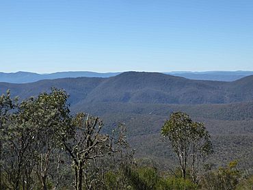
A view across Namadgi National Park in the Australian Capital Territory. This park is part of the South Eastern Highlands.
|
|||||||||||||||

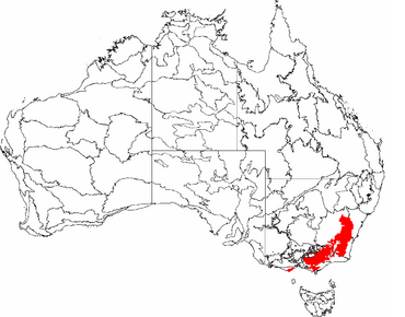
The red area shows where the South Eastern Highlands are located in Australia.
|
|||||||||||||||
| Area | 83,760 km2 (32,339.9 sq mi) | ||||||||||||||
|
|||||||||||||||
The South Eastern Highlands is a special natural area, also called a bioregion, in eastern Australia. It stretches across parts of New South Wales, the Australian Capital Territory, and Victoria. This large area covers about 8,375,961 hectares (20,697,450 acres) and is roughly 3,860 kilometres (2,400 mi) long.
To the south and west, you'll find the Australian Alps and the South West Slopes. To the northeast, it borders the Sydney Basin bioregion. The South East Corner bioregion is located to the east.
Besides Canberra, many other cities are part of this region. These include Orange in the north, Queanbeyan and Yass in the middle. Goulburn is in the east, and the town of Bombala is in the south. The South Eastern Highlands are also important for their natural resources. These include gold, copper, tin, oil, and natural gas.
This region is famous for its mountains and high flat areas called plateaus. These run along the eastern and southeastern parts of Australia. They form the Continental Divide, which even includes Tasmania. The highest point in mainland Australia, Mount Kosciuszko, is here. It stands tall at 2,228 metres (7,310 ft).
Contents
History of the Highlands
The South Eastern Highlands have been home to many different groups of people throughout history. These groups lived in various parts of the region. The Ngunnawal and Gandangara groups lived in the northern areas. The Ngarigo people lived in the southern and central parts. The Walbunja group also lived in the center with the Ngarigo. In the western part of the highlands, the Wagal group made their home.
Food and Resources
The South Eastern Highlands offered many resources for the people living there. They found plenty of vegetables to eat. The highlands also provided yams, daisy plants, and wattle seeds. These were very useful, especially in July and August. People also found fish, crayfish, possums, and other larger animals to hunt. This made the highlands a great place to live because people had everything they needed to survive.
European Settlement
Around the 1820s, Europeans started to settle in the South Eastern Highlands. They saw how much potential the land had. However, this new settlement changed the way of life for the original people. It also affected their natural resources.
There were reports of water shortages, which then impacted the animals that relied on the water. This meant fewer fish and other animals that came to drink. The arrival of Europeans also brought new diseases to the local people. One of these was the influenza epidemic.
New Discoveries
Even though European settlement caused some problems, it also brought some positive changes. Europeans discovered copper in the bioregion. This led to copper mining in the area. They also found gold, silver, antimony, and zinc. These discoveries greatly helped the economy. Miners who worked in the area also grew crops like apple, cherry, and plum trees. This gave people more food and other benefits.
Landforms and Geology
Highlands Topography
The South Eastern Highlands Bioregion includes parts of the Great Dividing Range. These mountains are located below the southwest Australian Alps. The region stretches east to the Great Escarpment. It also goes west to the slopes of the inland river basins and continues into Victoria.
Highlands Geology
The Highlands are part of the Lachlan Fold Belt. This belt runs through eastern Australia. It is made of old sandstones, shales, and volcanic rocks from the Ordovician to Devonian periods. These rocks were shaped by granite and changed by folding, faulting, and uplifting over millions of years. The main direction of these rock structures in this region is from north to south.
The oldest rocks are serpentinite rocks from the Early Ordovician period. They run from Gundagai past Tumut into the Snowy Mountains. These rare rocks formed deep in the ocean. They came to the surface when a piece of the seafloor and a chain of islands closed in on Australia's edge.
The Ordovician Molong Volcanic Arc is the largest ancient island chain. It stretches from the northern part of the bioregion to Kiandra. This area has different sediments from huge underwater landslides. It also has quartz sandstone and basaltic tuffs mixed in.
During the Devonian period, the region was an open sea. Fine sediments continued to collect here. Today, these are seen as shales, sandstone, and volcanic sediments. They are found in parallel troughs, like those at Tumut, Hill End, and from Captains Flat to Goulburn.
The Eastern Highlands have a series of mountains in the south, topped by Mount Kosciuszko. Further north, you can find volcanic plugs, ash domes, and old lava flows. There was a lot of volcanic activity here. Huge areas of river sands and gravels in the mid-Shoalhaven valley are from the Cenozoic era. Mount Canobolas was a major volcano, about 50 kilometres (31 mi) wide. Now, it's worn down, showing more than fifty old vents, plugs, and domes.
The main lava fields are in the Monaro area. Scientists have found 65 eruption centers there. They are between 34 and 55 million years old. The Highlands are very rich in minerals. They also contain most of Australia’s coalfields. In the Snowy Mountains, near Kiandra, people mined for gold in 18- to 20-million-year-old river gravels found on hilltops.
The main landforms in this bioregion are flat-topped areas called plateaus. There are also granite basins with ridges made from changed rocks. Streams in the bioregion have cut deep into the land. Valleys are very narrow. The landforms we see today are the result of millions of years of slow movement and erosion. These processes created the varied landscapes across Australia. They continue to change as the continent moves north.
Climate of the Highlands
The climate in the South Eastern Highlands changes a lot. This is because of the different heights of the land, which affect air pressure, light, wind, and rain. Most of the region has a mild climate. Summers are warm, and there isn't a dry season.
The average yearly temperature is between 6–16 °C (43–61 °F). The lowest temperature can be around −4 °C (25 °F). The highest can reach about 30 °C (86 °F). Strong winds, called gales, are common in the uplands. The strongest winds usually happen in the afternoons.
The average yearly rainfall varies. It ranges from 533 millimetres (21.0 in) in Cooma to 1,115 millimetres (43.9 in) in Cabramurra. Areas that are higher up usually get more rain. In the cooler months, much of this rain falls as snow.
Plants and Animals
The temperature affects both the soil and the types of plants and animals found here. You can see this in areas where frost collects.
Plant Life
The plants here include yellow box, red box, and Blakely’s red gum. In lower areas, you'll find white box. On hills in the west, Red Stringybark, peppermint, and white gum are common. Brown barrel trees are often seen in the east. River oak trees grow along the main streams. In the highest, coldest spots, there are patches of snow gum trees. In the swamps on the Boyd Plateau, you can find tea tree plants.
Soils that come from granite support apple box, yellow box, and some white box. Rocky areas have patches of black cypress pine. Cold plateaus with open woodlands have black sallee trees. River oak also grows along streams. Large grasslands are common on the driest plains of the Monaro. These are covered with snow grass, kangaroo grass, and wallaby grass. Sandy soils have peppermint, snappy gum, and forest oak.
There are 88 different types of plants in this bioregion. Sadly, 36 of them are endangered, and 50 are vulnerable. Two types, Stemmacantha and Gualium, are now extinct.
Animal Life
There are also 88 different animal species in the bioregion. Out of these, 25 are endangered, and 63 are vulnerable. Small honeyeaters are decreasing in number. This is because their natural areas are becoming broken up. Over time, birds like the noisy miner, Australian magpie, and grey butcherbird are also expected to decline.
Only a small number (seven percent) of the important animal species here are introduced ones. This suggests that the high-quality natural areas haven't changed much. However, the environment is slowly getting worse across the wider landscape.
Wetlands and Threats
There are no major wetlands officially recorded in this specific part of the South Eastern Highlands. However, several wetlands in the bioregion are considered very important for Australia. They are listed in the Directory of Important Wetlands in Australia.
These wetlands face many dangers. These include harmful weeds, wild animals, too much grazing, sedimentation (dirt building up), and changes in water flow. Driving and camping can also harm the plants and animals in these wetlands.
Sub-regions
The South Eastern Highlands bioregion has a special code in the IBRA system: (SEH). It is divided into sixteen smaller areas called sub-regions.
| IBRA regions and subregions: IBRA7 | ||||
|---|---|---|---|---|
| IBRA subregion | IBRA code |
Area | ||
| ha | acres | |||
| Highlands-Southern Fall | SEH01 | 1,196,334 | 2,956,210 | |
| Highlands-Northern Fall | SEH02 | 1,415,806 | 3,498,530 | |
| Otway Ranges | SEH03 | 149,857 | 370,300 | |
| Strzelecki Ranges | SEH04 | 342,045 | 845,210 | |
| Murrumbateman | SEH06 | 630,454 | 1,557,890 | |
| Bungonia | SEH07 | 431,185 | 1,065,480 | |
| Kanangra | SEH08 | 131,310 | 324,500 | |
| Crookwell | SEH09 | 466,523 | 1,152,800 | |
| Oberon | SEH10 | 293,164 | 724,420 | |
| Bathurst | SEH11 | 161,486 | 399,040 | |
| Orange | SEH12 | 284,172 | 702,200 | |
| Hill End | SEH13 | 504,377 | 1,246,340 | |
| Bondo | SEH14 | 541,990 | 1,339,300 | |
| Kybeyan-Gourock | SEH15 | 479,221 | 1,184,180 | |
| Monaro | SEH16 | 1,267,543 | 3,132,170 | |
| Capertee Uplands | SEH17 | 80,494 | 198,910 | |
See also
 In Spanish: Tierras altas del Sudeste para niños
 | Percy Lavon Julian |
 | Katherine Johnson |
 | George Washington Carver |
 | Annie Easley |

