Bombala facts for kids
Quick facts for kids BombalaNew South Wales |
|||||||||
|---|---|---|---|---|---|---|---|---|---|

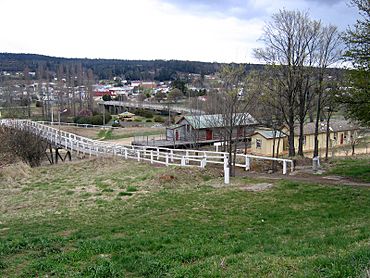
Bombala, looking towards the town centre. The footbridge passes over the Bombala railway line. The right most building is the station building, the centre building the goods shed and above that is the bridge over the Bombala River.
|
|||||||||
| Population | 1,892 (2021 census) | ||||||||
| Established | 1840s | ||||||||
| Postcode(s) | 2632 | ||||||||
| Elevation | 705 m (2,313 ft) | ||||||||
| Location | |||||||||
| LGA(s) | Snowy Monaro Regional Council | ||||||||
| County | Wellesley | ||||||||
| State electorate(s) | Monaro | ||||||||
| Federal Division(s) | Eden-Monaro | ||||||||
|
|||||||||
Bombala is a town in the southern part of New South Wales, Australia. It's located in the Monaro region, which is known for its beautiful landscapes. The town is about 485 kilometers (301 miles) south-southwest of Sydney, the state capital. It's also about 80 kilometers (50 miles) south of Cooma.
The name "Bombala" comes from an Aboriginal word. It means "Meeting of the waters," which makes sense because the town sits right on the banks of the Bombala River. In 2021, Bombala had a population of 1,892 people.
Contents
History of Bombala
The Bombala area was first home to the Ngarigu Aboriginal people. European settlers started arriving in the 1830s. Captain Ronald Campbell set up a large property called 'Bombalo' in 1833. More settlers came in the 1840s, and that's when the small town began to grow.
By 1849, Bombala had a post office. By the mid-1850s, it had many important buildings. In 1903, a politician named King O'Malley suggested Bombala as the place for Australia's capital city. It was considered because it was halfway between Sydney and Melbourne. However, Canberra was chosen instead.
Today, Bombala's main industries are farming, especially raising animals, and timber production. Tourism is also becoming more important. Some special farms grow things like meat rabbits, lavender, and many herbs.
A cool historical fact: on December 13, 1962, the Bombala post office received the very last telegram sent using Morse code in New South Wales.
The area is famous for having a large number of Platypus in New South Wales. Because of this, it's often called "Platypus Country."
On January 15, 2022, a tornado touched down near the town. Recently, Bombala has seen new jobs created by renewable energy projects. The yearly 'Bombala Show' celebrates local farming, crafts, and community spirit. It's a big event that brings people together.
Heritage Sites
Bombala has some places that are important for their history. These are called heritage-listed sites:
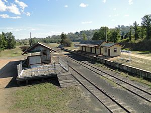
- The old railway line from Goulburn to Bombala: Bombala railway station
- 91 Main Road: Crankies Plain Bridge
Geography and Climate
Bombala is located 705 meters (2,313 feet) above sea level. It's on the edge of the Monaro Tablelands. This means Bombala has cold winters with lots of frost and often gets snow. Sometimes, it even snows in late spring! Even in summer, you can get frosts.
Just a few kilometers to the east, the land goes down towards the South Coast. This is a flat area where summers are warmer and winters are much milder. Towns like Bega and Merimbula are about 80 kilometers (50 miles) east of Bombala. Bombala has an oceanic climate, which means it has mild temperatures and rain throughout the year.
Most of the rain in Bombala comes from cold fronts. These can sometimes cause strong thunderstorms in spring and summer. The highest temperature ever recorded was 41.5 °C (105.6 °F). The lowest was a very cold −10.0 °C (14.0 °F).
| Climate data for Bombala (Therry Street, 1912–2022, rainfall to 1885); 705 m AMSL; 36.91° S, 149.24° E | |||||||||||||
|---|---|---|---|---|---|---|---|---|---|---|---|---|---|
| Month | Jan | Feb | Mar | Apr | May | Jun | Jul | Aug | Sep | Oct | Nov | Dec | Year |
| Record high °C (°F) | 41.5 (106.7) |
40.7 (105.3) |
36.4 (97.5) |
31.1 (88.0) |
26.7 (80.1) |
22.1 (71.8) |
21.3 (70.3) |
24.5 (76.1) |
30.1 (86.2) |
32.0 (89.6) |
37.5 (99.5) |
38.5 (101.3) |
41.5 (106.7) |
| Mean daily maximum °C (°F) | 25.6 (78.1) |
25.0 (77.0) |
22.6 (72.7) |
18.6 (65.5) |
14.8 (58.6) |
11.6 (52.9) |
11.1 (52.0) |
12.8 (55.0) |
15.9 (60.6) |
18.9 (66.0) |
21.3 (70.3) |
23.9 (75.0) |
18.5 (65.3) |
| Mean daily minimum °C (°F) | 10.5 (50.9) |
10.6 (51.1) |
8.6 (47.5) |
5.3 (41.5) |
2.0 (35.6) |
−0.1 (31.8) |
−1.1 (30.0) |
−0.1 (31.8) |
2.3 (36.1) |
4.7 (40.5) |
7.0 (44.6) |
9.0 (48.2) |
4.9 (40.8) |
| Record low °C (°F) | 0.4 (32.7) |
1.3 (34.3) |
−0.2 (31.6) |
−5.0 (23.0) |
−7.1 (19.2) |
−10.0 (14.0) |
−9.6 (14.7) |
−8.0 (17.6) |
−6.4 (20.5) |
−4.7 (23.5) |
−2.0 (28.4) |
−0.4 (31.3) |
−10.0 (14.0) |
| Average precipitation mm (inches) | 64.2 (2.53) |
58.7 (2.31) |
61.1 (2.41) |
45.2 (1.78) |
43.5 (1.71) |
59.8 (2.35) |
46.0 (1.81) |
40.2 (1.58) |
44.5 (1.75) |
56.3 (2.22) |
65.5 (2.58) |
64.1 (2.52) |
650.9 (25.63) |
| Average rainy days (≥ 0.2mm) | 8.2 | 7.7 | 8.4 | 8.1 | 9.2 | 10.4 | 9.4 | 10.1 | 10.3 | 10.4 | 9.9 | 9.1 | 111.2 |
| Average afternoon relative humidity (%) | 51 | 55 | 54 | 58 | 63 | 64 | 59 | 56 | 54 | 53 | 52 | 54 | 56 |
| Source: Bureau of Meteorology | |||||||||||||
Sports in Bombala
The most popular sport in Bombala is rugby league. The local team is called the Bombala Blue Heelers. They play in the Group 16 Rugby League competition. The team actually joined with the Delegate Tigers in the 1980s. So, the club is officially known as Bombala-Delegate.
Transportation
The railway line reached Bombala in 1921. It was an extension of the line from Queanbeyan to Cooma. The train service stopped in 1986. In the 1970s, a small rail bus would take about 4 hours to travel the 100 kilometers (62 miles) between Cooma and Bombala.
The Monaro Highway (also known as route B23) goes through Bombala. This highway connects Canberra to Cann River in Victoria. Another important road is Mt Darragh Road. It connects Bombala to coastal towns like Pambula and Merimbula.
The closest airport with regular flights is in Merimbula. It is about 85 kilometers (53 miles) east of Bombala.
Population Information
| Historical population | ||
|---|---|---|
| Year | Pop. | ±% |
| 1921 | 978 | — |
| 1933 | 931 | −4.8% |
| 1947 | 1,111 | +19.3% |
| 1954 | 1,258 | +13.2% |
| 1961 | 1,389 | +10.4% |
| 1966 | 1,495 | +7.6% |
| 1971 | 1,489 | −0.4% |
| 1976 | 1,474 | −1.0% |
| 1981 | 1,504 | +2.0% |
| 1986 | 1,458 | −3.1% |
| 1991 | 1,404 | −3.7% |
| 1996 | 1,380 | −1.7% |
| 2001 | 1,222 | −11.4% |
| 2006 | 1,206 | −1.3% |
| 2011 | 1,211 | +0.4% |
| 2016 | 1,197 | −1.2% |
| 2021 | 1,136 | −5.1% |
| Source: Australian Bureau of Statistics data. | ||
In the 2021 Census, there were 1,892 people living in the wider Bombala area. About 1,136 people lived in the main town area. Most people (83.2%) were born in Australia. Also, 89.2% of people spoke only English at home. The most common religions were Anglican (26.8%), Catholic (21.7%), and No Religion (29.2%).
Famous People from Bombala
- Minard Crommelin (1881–1972): She was a postmistress and worked to protect the environment. She was born near Bombala.
- Michael Farrell (born 1965): A modern poet and magazine editor, born in Bombala.
- Sir Alexander George William "Bill" Keys (1923–2000): He was a long-time president of the Returned and Services League (RSL). He grew up in Bombala.
- Dick Tooth (born 1929): A former Australian rugby union player, born in Bombala.
- William Farmer Whyte (1877–1958): A journalist and author.
- Charles Henry Kerry (1857–1928): A famous photographer.
- Wilfred Alexander de Beuzeville (1884–1954): A forester, someone who manages forests.
- Ky Rodwell: A rugby league footballer.


