Cabramurra, New South Wales facts for kids
Quick facts for kids CabramurraNew South Wales |
|||||||||
|---|---|---|---|---|---|---|---|---|---|

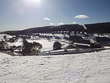
Cabramurra town, afternoon in winter, looking north from the lookout
|
|||||||||
| Population | 37 (2016 census) | ||||||||
| Established | 1954 | ||||||||
| Postcode(s) | 2629 | ||||||||
| Elevation | 1,488 m (4,882 ft) | ||||||||
| Location | |||||||||
| LGA(s) | Snowy Valleys Shire | ||||||||
| State electorate(s) | Albury | ||||||||
| Federal Division(s) | Eden-Monaro | ||||||||
|
|||||||||
Cabramurra is a small town high up in the Snowy Mountains of New South Wales, Australia. It sits at about 1,488 metres (4,882 ft) above sea level, making it the highest town in Australia. It's part of the Great Dividing Range, which is a long chain of mountains and hills that runs along the eastern side of Australia.
The town's name, Cabramurra, might come from the Wiradjuri language, an Aboriginal language. It could mean "crooked hand".
For many years, from the 1950s until 2018, people lived in Cabramurra to work on the Snowy Mountains Scheme. This was a huge project that built dams and power stations to create electricity. The town had shops, a school, and even a pub for the workers and their families. However, now most workers travel in and out for their shifts instead of living there.
Contents
History of Cabramurra
Building a Mountain Town
Cabramurra was first set up in 1954. It was built to house workers for the Snowy Mountains Scheme. This big project created hydro-electricity, which is power made from moving water. Before the town was built, a small camp for surveyors was there in 1951.
The first houses in Cabramurra were "prefabricated." This means they were built in sections somewhere else and then put together quickly on site.
Moving the Town and New Homes
In 1974, the town was actually moved! It shifted about 500 meters (1,640 feet) and 20 meters (66 feet) higher up to a spot that was more protected from the weather. The old town site became a lookout point where you can see great views.
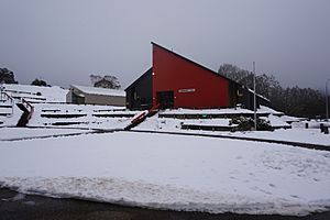
The original houses were either taken down or moved to other nearby towns like Talbingo, Adaminaby, and Jindabyne. The new houses were built using strong concrete blocks called Besser blocks. They were designed especially for the cold, snowy mountain environment. They have very steep roofs so that snow can easily slide off them. Inside, a central heater warms all the rooms. All the power and phone lines in the town are buried underground to protect them from the weather.
Bushfire Damage in 2020
In early 2020, a big bushfire caused damage to Cabramurra. Many houses and buildings, including the school and the old ski club, were unfortunately lost in the fire.
Life in Cabramurra Today
A Company Town
Cabramurra is known as a "company town." This means it's mainly for people who work for Snowy Hydro. These workers operate the nearby power stations and dams, like Tumut 1 and Tumut 2. Only people who work directly for Snowy Hydro and their families are allowed to live in the town.
Town Facilities
The town has about 45 houses and over 100 units. There's a general store where you can buy everyday things and a petrol station. It also has a primary school, a pub (called a wet canteen or tavern), an indoor swimming pool, and tennis courts. There's even a small downhill ski slope with a "Poma" tow lift.
For bigger shopping trips or if someone needs a hospital, the nearest large towns are Canberra, Tumut, and Cooma. If there's an emergency, people can be flown out by helicopter.
School Life
The primary school in Cabramurra has just one classroom and one teacher who teaches all the children. For high school, kids usually go to Tumbarumba or Cooma. A bus takes students to Tumbarumba every day.
Unique Location
Cabramurra is located inside Kosciuszko National Park. It's on the road that connects Kiandra in the north to Khancoban in the south. During winter, snow ploughs keep the road open to Kiandra, which also helps people get to the Selwyn Snowfields ski resort. However, the road south of Tumut Pond Dam is closed in winter.
A short airstrip near the town is sometimes used by military planes practicing landings and takeoffs. The town's water comes from a place called "Dry Dam" near this airstrip.
Winter Wonderland
Unlike most of Australia, Cabramurra gets a lot of snow in winter. It can be covered in snow for three to four months! This is why the houses have those very steep roofs. The town's small ski run was actually the first in Australia to have lights for night skiing.
Even though the permanent workers are now mostly "drive-in/drive-out," the school will stay open for children in the area. There are no places for visitors to stay overnight in Cabramurra.
Climate in Cabramurra
Cabramurra has a cold oceanic climate. This means it has cool summers and very cold, snowy winters. Even though it's very wet in winter, it often gets more sunshine than places lower down, like Khancoban. This is because Cabramurra is high enough to be above the clouds and fog that often cover lower areas in winter.
Because Cabramurra is on the side of the mountains, very cold air tends to drain into the valleys below. This means Cabramurra often has milder minimum temperatures than other high places nearby, like Kiandra. For Cabramurra to get extremely cold temperatures, it usually needs a lot of snow on the ground. The town is usually covered in snow from June to September because it's well above the snow line. On average, Cabramurra has about 53 snowy days each year.
| Climate data for Cabramurra SMHEA (1962–1999, rainfall to 1955); 1,475 m AMSL; 35.94° S, 148.38° E | |||||||||||||
|---|---|---|---|---|---|---|---|---|---|---|---|---|---|
| Month | Jan | Feb | Mar | Apr | May | Jun | Jul | Aug | Sep | Oct | Nov | Dec | Year |
| Record high °C (°F) | 31.1 (88.0) |
31.9 (89.4) |
27.5 (81.5) |
23.6 (74.5) |
18.9 (66.0) |
13.8 (56.8) |
11.6 (52.9) |
14.9 (58.8) |
19.8 (67.6) |
22.5 (72.5) |
28.5 (83.3) |
28.4 (83.1) |
31.9 (89.4) |
| Mean daily maximum °C (°F) | 19.7 (67.5) |
19.9 (67.8) |
16.7 (62.1) |
12.1 (53.8) |
8.0 (46.4) |
4.9 (40.8) |
3.1 (37.6) |
3.9 (39.0) |
7.1 (44.8) |
11.4 (52.5) |
14.3 (57.7) |
17.4 (63.3) |
11.5 (52.8) |
| Mean daily minimum °C (°F) | 9.6 (49.3) |
9.9 (49.8) |
7.8 (46.0) |
4.7 (40.5) |
2.0 (35.6) |
−0.4 (31.3) |
−1.8 (28.8) |
−1.2 (29.8) |
0.5 (32.9) |
3.2 (37.8) |
5.4 (41.7) |
7.8 (46.0) |
4.0 (39.1) |
| Record low °C (°F) | −0.5 (31.1) |
−2.1 (28.2) |
−3.4 (25.9) |
−7.2 (19.0) |
−7.4 (18.7) |
−7.3 (18.9) |
−11.0 (12.2) |
−11.2 (11.8) |
−8.1 (17.4) |
−7.2 (19.0) |
−5.1 (22.8) |
−2.7 (27.1) |
−11.2 (11.8) |
| Average precipitation mm (inches) | 99.2 (3.91) |
66.6 (2.62) |
91.0 (3.58) |
110.7 (4.36) |
165.3 (6.51) |
164.8 (6.49) |
204.5 (8.05) |
203.9 (8.03) |
172.6 (6.80) |
177.4 (6.98) |
126.9 (5.00) |
117.2 (4.61) |
1,700.1 (66.94) |
| Average precipitation days (≥ 0.2 mm) | 9.5 | 8.1 | 9.5 | 10.5 | 13.9 | 15.1 | 17.3 | 18.1 | 15.7 | 14.7 | 12.9 | 10.8 | 156.1 |
| Mean monthly sunshine hours | 288.3 | 251.4 | 241.8 | 195.0 | 142.6 | 114.0 | 111.6 | 124.0 | 156.0 | 213.9 | 240.0 | 282.1 | 2,360.7 |
| Source: Australian Bureau of Meteorology; Cabramurra SMHEA | |||||||||||||
| Climate data for Cabramurra SMHEA AWS (1996–2023); 1,482 m AMSL; 35.94° S, 148.38° E | |||||||||||||
|---|---|---|---|---|---|---|---|---|---|---|---|---|---|
| Month | Jan | Feb | Mar | Apr | May | Jun | Jul | Aug | Sep | Oct | Nov | Dec | Year |
| Record high °C (°F) | 34.0 (93.2) |
31.5 (88.7) |
28.4 (83.1) |
23.3 (73.9) |
16.4 (61.5) |
15.0 (59.0) |
11.8 (53.2) |
15.5 (59.9) |
18.9 (66.0) |
23.5 (74.3) |
27.6 (81.7) |
30.3 (86.5) |
34.0 (93.2) |
| Mean daily maximum °C (°F) | 21.5 (70.7) |
20.5 (68.9) |
17.4 (63.3) |
12.9 (55.2) |
8.4 (47.1) |
5.3 (41.5) |
3.9 (39.0) |
5.0 (41.0) |
8.7 (47.7) |
12.3 (54.1) |
15.5 (59.9) |
18.6 (65.5) |
12.5 (54.5) |
| Mean daily minimum °C (°F) | 11.7 (53.1) |
11.0 (51.8) |
8.8 (47.8) |
5.9 (42.6) |
2.7 (36.9) |
0.5 (32.9) |
−0.8 (30.6) |
−0.5 (31.1) |
1.8 (35.2) |
4.3 (39.7) |
7.0 (44.6) |
9.2 (48.6) |
5.1 (41.2) |
| Record low °C (°F) | −0.7 (30.7) |
0.2 (32.4) |
−1.3 (29.7) |
−3.7 (25.3) |
−5.1 (22.8) |
−7.0 (19.4) |
−7.0 (19.4) |
−6.8 (19.8) |
−6.5 (20.3) |
−6.0 (21.2) |
−4.7 (23.5) |
−3.0 (26.6) |
−7.0 (19.4) |
| Average precipitation mm (inches) | 75.6 (2.98) |
79.4 (3.13) |
86.9 (3.42) |
76.4 (3.01) |
94.2 (3.71) |
124.5 (4.90) |
113.8 (4.48) |
127.7 (5.03) |
126.7 (4.99) |
111.7 (4.40) |
122.2 (4.81) |
90.1 (3.55) |
1,229.2 (48.41) |
| Average precipitation days (≥ 0.2 mm) | 8.1 | 7.4 | 8.2 | 7.9 | 10.6 | 13.3 | 14.7 | 14.4 | 12.8 | 11.2 | 10.9 | 8.6 | 128.1 |
| Average afternoon relative humidity (%) | 52 | 54 | 56 | 64 | 75 | 82 | 83 | 79 | 72 | 65 | 61 | 54 | 66 |
| Source: Australian Bureau of Meteorology; Cabramurra SMHEA AWS | |||||||||||||
Images for kids
 | Chris Smalls |
 | Fred Hampton |
 | Ralph Abernathy |


