Tumbarumba facts for kids
Quick facts for kids TumbarumbaNew South Wales |
|||||||||
|---|---|---|---|---|---|---|---|---|---|
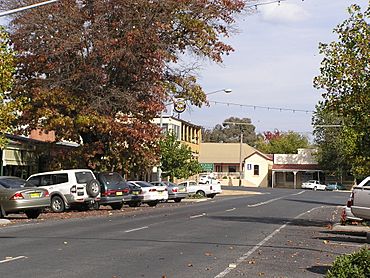
The Parade, Main street of Tumbarumba
|
|||||||||
| Population | 1,862 (2016 census) | ||||||||
| Established | 1850s | ||||||||
| Postcode(s) | 2653 | ||||||||
| Elevation | 645 m (2,116 ft) | ||||||||
| Location |
|
||||||||
| LGA(s) | Snowy Valleys Council | ||||||||
| County | Selwyn | ||||||||
| State electorate(s) | Albury | ||||||||
| Federal Division(s) | Eden-Monaro | ||||||||
|
|||||||||
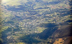
Tumbarumba is a town in New South Wales, Australia. It is about 480 kilometers (298 miles) southwest of Sydney, the state capital. Tumbarumba is located near the Riverina and South West Slopes regions. It sits at the western edge of the Snowy Mountains. In 2016, about 1,862 people lived in the town and its surrounding areas. Locals often call the town 'Tumba'.
If you look south and east, you can see Mount Kosciuszko. This is the highest peak in the Snowy Mountains and on mainland Australia.
Contents
History of Tumbarumba
The history of the Aboriginal people in the Tumbarumba area has different stories. Maps from Tindale show that Tumbarumba was where the lands of the Wiradjuri and Walgalu peoples met. These groups spoke different languages. The Walgalu people spoke the same Ngarigo language as the Ngarigo people from the Monaro region. Today, some people see the Walgalu and Ngarigo as one group. Their lands included Tumbarumba.
There are different ideas about where the name 'Tumbarumba' comes from. It might be from the Wiradjuri or Ngarigo language. Some think it means "hollow sounding ground," "thunder," "sound," or "place of big trees." The area is now part of the Brungle/Tumut Aboriginal Land Council.
Settlers started a community in the late 1850s. This happened after gold was found in the area. The Post Office opened on August 1, 1860. It was spelled Tumberumba until 1915.
A railway line reached Tumbarumba in 1921. The Tumbarumba railway line came from Wagga Wagga. The train service stopped in September 1974. The line is now closed. A 21-kilometer (13-mile) part of the line is now a rail trail. This section, between Rosewood and Tumbarumba, opened in April 2020. It was the first rail trail in New South Wales.
Gold mining slowed down in the 1930s. Now, the area's economy relies on farming and tourism. The timber industry is very important to the local economy.
What Tumbarumba Makes
The main industry in Tumbarumba is processing softwood timber. The Hyne and Sons Timber Mill is west of town. It is the biggest employer there. Other important industries include tourism and growing grapes for wine. Tumbarumba is part of the Tumbarumba wine region. Growing blueberries is also a local industry. Tourism brings money to the town because it is close to the snow fields.
Things to Do in Tumbarumba
Tumbarumba is a great place to stay if you want to visit the Western Snowy Mountains.
The town is on the Snowy Valleys Way. This is a scenic driving route between Sydney and Melbourne. The Snowy Valleys Way connects Gundagai and Beechworth. It passes through Tumut, Tumbarumba, and Corryong.
Tumbarumba is also near the 440-kilometer (273-mile) Hume and Hovell Track. You can get onto the track at the Henry Angel Trackhead. This is 9 kilometers (5.6 miles) from Tumbarumba towards Khancoban. A half-day walk from Henry Angel Trackhead to 'Big Hill' offers views of the western side of the Snowy Mountains Main Range. This walk also goes past old gold mining sites at Burra Falls.
Tumbarumba is the center of the Tumbarumba wine region. This is a growing wine area with a cool climate. The first grapes were planted here in 1982. Several local wineries have 'cellar doors' where you can buy wines.
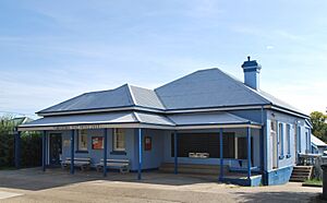
The Museum and Visitor Information Centre is on Bridge Street. It is open almost every day of the year. The Tumbarumba Library and Archive is on Prince Street. It is open Monday to Saturday, but check for specific hours.
The Tumbarumba to Rosewood Rail Trail opened in April 2020. This rail trail is a 21-kilometer (13-mile) path for walking and cycling. It follows the old Tumbarumba railway line. The rail trail has helped bring more tourists to the area.
Schools in Tumbarumba
Tumbarumba has three schools. Tumbarumba Public School and All Saints Primary School (Catholic) teach younger students. Tumbarumba High School provides education for older students in the area.
Events in Tumbarumba
The Tumbarumba Rodeo happens every year on New Year's Day (January 1). It takes place at the Tumbarumba Showground.
Tumbafest is another yearly event. It is a music, wine, and market festival held on the last weekend of February. Famous acts like Leo Sayer have performed there.
Tumbarumba Tastebuds is a festival that celebrates local food, wine, and art. It is held in the Spring.
Weather in Tumbarumba
Tumbarumba has a mild oceanic climate. This means it has a good range of temperatures throughout the year. It also gets a lot of rain in winter. Frosts happen often during many months of the year. Snow is quite common, usually falling about two days a year. However, it is usually light snow because the town is in a valley.
The lowest temperature ever recorded was -9.4°C (15.1°F) on July 13, 1970. The town has about 109 clear days each year. Most of these clear days are in summer and early autumn. Winters tend to be quite cloudy.
Sports in Tumbarumba
The Tumbarumba Greens have rugby league teams. They play in the Murray Cup competition. The club is famous for having a full team of Goldspinks playing in the 1960s.
The Tumbarumba Kangaroos is an Australian rules football club. It was started in 1969. They play in the Upper Murray Football League, which is based in Victoria.
Famous People from Tumbarumba
- Jack Blomley - A player for the Wallabies rugby union team.
- Jack Loes - An Australian rules footballer.
- John Williams - A scientist.
See also
 In Spanish: Tumbarumba para niños
 | Chris Smalls |
 | Fred Hampton |
 | Ralph Abernathy |


