Rosewood, New South Wales facts for kids
Quick facts for kids RosewoodNew South Wales |
|||||||||
|---|---|---|---|---|---|---|---|---|---|

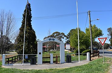
War memorial at Rosewood, 2020
|
|||||||||
| Population | 214 (2016 census) | ||||||||
| Postcode(s) | 2652 | ||||||||
| Elevation | 602 m (1,975 ft) | ||||||||
| Location |
|
||||||||
| LGA(s) |
|
||||||||
| County | Selwyn | ||||||||
| State electorate(s) | Albury | ||||||||
| Federal Division(s) | Eden-Monaro | ||||||||
|
|||||||||
Rosewood is a small village in the southeast of New South Wales, Australia. It's located in an area called the Riverina. Rosewood is about 16 kilometers (10 miles) southeast of Carabost. It's also about 19 kilometers (12 miles) northwest of Tumbarumba. In 2016, about 214 people lived in Rosewood. The village is managed by two local councils: the Greater Hume Shire and the Snowy Valleys Council. The main part of Rosewood village is in the Snowy Valleys Council area.
Contents
A Look Back in Time
Rosewood has a simple but interesting history. The local Post Office, which is a place where people send and receive mail, first opened its doors on August 1, 1885.
Important Old Places
Rosewood has some special places that are protected because of their history. These are called heritage-listed sites. One of these important places is the Coppabella Blacksmith Shop. A blacksmith is someone who works with metal, shaping it with heat and tools.
The Tumbarumba to Rosewood Rail Trail
What is a Rail Trail?
A rail trail is a path built on an old railway line. It's a great place for walking, running, and cycling. It lets people enjoy nature and get exercise.
Rosewood's Rail Trail
Rosewood is at one end of a 21-kilometer (13-mile) long rail trail. This trail starts in Tumbarumba and follows part of an old railway line. The trail opened on April 3, 2020. The rest of the old railway, between Rosewood and Wagga Wagga, hasn't been used since 1987. Most of it is still there, but it's not in good shape. Some parts of the track have even been removed. This rail trail is seen as a "pilot" project. This means it might be extended further past Rosewood in the future.
Rosewood's Weather
How the Climate Works
Rosewood is located where two different areas meet: the South West Slopes and the Riverina plain. It's also in an area with many pine plantations. Because of its location, Rosewood has cooler temperatures than you might expect for its height above sea level.
Temperature and Rainfall
The average highest temperature in Rosewood is about 19.1°C (66.4°F). This is similar to places like Cooma, even though Rosewood is much lower in altitude. Winters in Rosewood are especially cool. The area also gets a good amount of rain, with an average of 906.3 millimeters (35.7 inches) each year.
| Climate data for Brookfield Forest Station (1938–1968); 457 m AMSL; 35.80° S, 147.93° E | |||||||||||||
|---|---|---|---|---|---|---|---|---|---|---|---|---|---|
| Month | Jan | Feb | Mar | Apr | May | Jun | Jul | Aug | Sep | Oct | Nov | Dec | Year |
| Mean daily maximum °C (°F) | 28.7 (83.7) |
27.7 (81.9) |
24.8 (76.6) |
19.1 (66.4) |
14.5 (58.1) |
10.9 (51.6) |
9.9 (49.8) |
11.8 (53.2) |
15.6 (60.1) |
18.6 (65.5) |
21.8 (71.2) |
26.0 (78.8) |
19.1 (66.4) |
| Mean daily minimum °C (°F) | 10.1 (50.2) |
10.1 (50.2) |
7.5 (45.5) |
3.9 (39.0) |
1.4 (34.5) |
0.2 (32.4) |
−0.8 (30.6) |
0.3 (32.5) |
1.7 (35.1) |
4.0 (39.2) |
6.0 (42.8) |
7.9 (46.2) |
4.4 (39.9) |
| Average precipitation mm (inches) | 56.0 (2.20) |
47.2 (1.86) |
65.5 (2.58) |
65.6 (2.58) |
86.2 (3.39) |
82.3 (3.24) |
99.0 (3.90) |
92.3 (3.63) |
81.6 (3.21) |
98.7 (3.89) |
70.8 (2.79) |
60.1 (2.37) |
906.3 (35.68) |
| Average precipitation days (≥ 0.2 mm) | 6.0 | 5.6 | 6.3 | 8.0 | 10.8 | 12.7 | 13.9 | 14.5 | 10.7 | 11.9 | 8.5 | 7.3 | 116.2 |
| Source: Australian Bureau of Meteorology; Brookfield Forest Station | |||||||||||||
 | George Robert Carruthers |
 | Patricia Bath |
 | Jan Ernst Matzeliger |
 | Alexander Miles |


