Carabost, New South Wales facts for kids
Quick facts for kids CarabostNew South Wales |
|||||||||
|---|---|---|---|---|---|---|---|---|---|

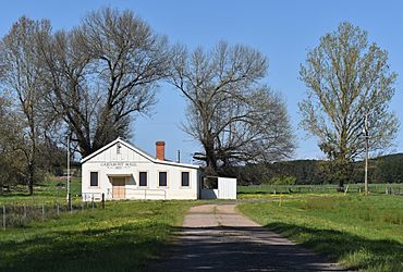
Carabost Hall, 2020
|
|||||||||
| Postcode(s) | 2650 | ||||||||
| Elevation | 551 m (1,808 ft) | ||||||||
| Location |
|
||||||||
| County | Wynyard | ||||||||
| State electorate(s) | Albury | ||||||||
|
|||||||||
Carabost is a small community located in the southeastern part of the Riverina region in New South Wales, Australia. It's known for its surrounding forests and Pine tree farms.
The community is about 16 kilometres northwest of Rosewood and 22 kilometres southeast of Kyeamba. Carabost is situated on the Tumbarumba Road, close to the Carabost National Forest.
Contents
What You'll Find in Carabost
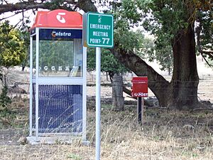
Carabost is a quiet place with only a few buildings. The main ones are the Carabost Town Hall, which was built in 1927, and a Fire Brigade Shed. You can also find a public telephone box and a post box. These are all located at the community's emergency gathering point. This spot is used if there's a forest fire or another big emergency in the area.
The Name Carabost
The name Carabost comes from Scottish Gaelic. It's the Gaelic version of Carbost, which is a place on the Scottish island of Skye. The name means Copse farm, which refers to a farm near a small group of trees.
A Look Back at Carabost's History
Carabost has a bit of history, especially with its post office and gold.
Carabost Post Office
The Carabost Post Office first opened a long time ago, on 1 March 1879. However, it closed down a few years later, on 4 March 1897. It then reopened on 1 January 1915 but closed again on 27 January 1968.
Gold Mining in the Area
People knew there was gold in the Carabost area as early as the late 1880s. However, Carabost wasn't as famous for gold as its nearby mining towns, Humula and Tumbarumba. During the 1920s, some parts of Carabost were mined for gold using a method called dredging. This involves using large machines to dig up riverbeds or ground to find gold.
Climate in Carabost
Carabost is located on higher ground in the South West Slopes region. This means it often gets cooler temperatures, especially when westerly winds blow. In July, which is winter, the average high temperature is about 9.1 degrees Celsius.
A weather station was set up in a pine plantation at Carabost Forest Headquarters. It operated from 1938 to 1969.
| Climate data for Carabost Forest Headquarters (1938–1969); 580 m AMSL; 35.65° S, 147.80° E | |||||||||||||
|---|---|---|---|---|---|---|---|---|---|---|---|---|---|
| Month | Jan | Feb | Mar | Apr | May | Jun | Jul | Aug | Sep | Oct | Nov | Dec | Year |
| Mean daily maximum °C (°F) | 28.0 (82.4) |
27.2 (81.0) |
24.1 (75.4) |
18.7 (65.7) |
13.7 (56.7) |
10.8 (51.4) |
9.1 (48.4) |
10.8 (51.4) |
14.3 (57.7) |
18.0 (64.4) |
21.1 (70.0) |
25.4 (77.7) |
18.4 (65.2) |
| Mean daily minimum °C (°F) | 11.0 (51.8) |
11.2 (52.2) |
9.0 (48.2) |
5.6 (42.1) |
3.2 (37.8) |
1.7 (35.1) |
0.2 (32.4) |
1.7 (35.1) |
3.2 (37.8) |
5.5 (41.9) |
7.0 (44.6) |
9.0 (48.2) |
5.7 (42.3) |
| Average precipitation mm (inches) | 56.4 (2.22) |
48.6 (1.91) |
61.2 (2.41) |
72.6 (2.86) |
96.4 (3.80) |
92.8 (3.65) |
112.5 (4.43) |
107.6 (4.24) |
84.4 (3.32) |
100.1 (3.94) |
70.5 (2.78) |
60.1 (2.37) |
966.5 (38.05) |
| Average precipitation days (≥ 0.2 mm) | 5.1 | 4.7 | 5.4 | 7.0 | 9.7 | 10.7 | 12.6 | 13.0 | 10.1 | 10.1 | 7.8 | 6.2 | 102.4 |
| Source: Australian Bureau of Meteorology; Carabost Forest Headquarters | |||||||||||||
 | Stephanie Wilson |
 | Charles Bolden |
 | Ronald McNair |
 | Frederick D. Gregory |


