Humula facts for kids
Quick facts for kids HumulaNew South Wales |
|||||||||
|---|---|---|---|---|---|---|---|---|---|

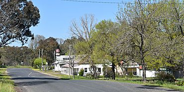
Mate St, the main street of Humula, 2020
|
|||||||||
| Population | 124 (2016 census Census) | ||||||||
| Postcode(s) | 2652 | ||||||||
| Elevation | 301 m (988 ft) | ||||||||
| Location | |||||||||
| LGA(s) | City of Wagga Wagga | ||||||||
| County | Wynyard | ||||||||
| State electorate(s) | Wagga Wagga | ||||||||
|
|||||||||
Humula is a small country town in New South Wales, Australia. It is located between the towns of Tarcutta and Tumbarumba.
Long ago, during the gold rush, Humula was known as "American Yards" or "American Fields." Many people, including Chinese miners, came here hoping to find gold. In 2016, a count of the population showed that 124 people lived in Humula.
The town is found where Carabost Creek meets Umbango Creek. This area is part of the larger Murrumbidgee catchment. Just outside the town is Humula Station, a very old and important farm. It is known for its history in farming and raising animals.
Life in Humula
Even though Humula is a small town, it has important services for its residents. It has its own fire brigade to help with emergencies. There is also a public school for children. The town also has a recreation ground where people can play sports and relax.
Humula has faced many bushfires over the years. One of the most recent big fires was in February 2006. Despite these challenges, the town has always managed to rebuild and stay strong.
Humula's History
Humula has been around for more than 100 years. Some of its older buildings still stand today. You can find the old butcher's shop at the end of Mate Street. The Humula Public School on School Street is another historic building. You can also see the ruins of the old Humula Hotel.
The town once had a police station on School Street. In the late 1970s and 1980s, Humula was a very busy place. This was because logging, which is cutting down trees for wood, was the main industry. The Humula sawmill gave jobs to many people.
When the sawmill closed, many people left Humula. The town became much quieter, almost like a ghost town. Today, the Sports Club is one of the few businesses still open. Outside the town, much of the farming land has been turned into pine tree plantations.
Humula also used to have its own railway station. It was part of the Tumbarumba railway line. However, the railway is no longer used. The Post Office closed several years ago. The General Store, which was much smaller, also closed around 2016.
Climate
Humula is located where the slopes of the Great Dividing Range meet the Riverina plain. This means it has a wide range of temperatures throughout the year. It also gets more rain in winter.
| Climate data for Murraguldrie State Forest 1 (1938–1974); 493 m AMSL; 35.50° S, 147.62° E | |||||||||||||
|---|---|---|---|---|---|---|---|---|---|---|---|---|---|
| Month | Jan | Feb | Mar | Apr | May | Jun | Jul | Aug | Sep | Oct | Nov | Dec | Year |
| Mean daily maximum °C (°F) | 29.7 (85.5) |
28.6 (83.5) |
25.4 (77.7) |
20.4 (68.7) |
15.6 (60.1) |
11.6 (52.9) |
10.5 (50.9) |
12.2 (54.0) |
15.8 (60.4) |
19.3 (66.7) |
22.4 (72.3) |
26.8 (80.2) |
19.9 (67.7) |
| Mean daily minimum °C (°F) | 13.5 (56.3) |
14.1 (57.4) |
11.5 (52.7) |
7.2 (45.0) |
4.4 (39.9) |
2.6 (36.7) |
1.6 (34.9) |
2.2 (36.0) |
4.2 (39.6) |
6.6 (43.9) |
9.6 (49.3) |
12.0 (53.6) |
7.5 (45.4) |
| Average precipitation mm (inches) | 58.0 (2.28) |
50.9 (2.00) |
61.7 (2.43) |
73.9 (2.91) |
81.1 (3.19) |
81.1 (3.19) |
95.0 (3.74) |
95.1 (3.74) |
71.9 (2.83) |
91.0 (3.58) |
76.8 (3.02) |
55.3 (2.18) |
891.8 (35.09) |
| Average precipitation days (≥ 0.2 mm) | 5.5 | 5.6 | 5.2 | 8.2 | 9.9 | 10.4 | 13.6 | 15.6 | 11.5 | 11.0 | 9.1 | 6.5 | 112.1 |
| Source: Australian Bureau of Meteorology; Murraguldrie State Forest 1 | |||||||||||||
 | Emma Amos |
 | Edward Mitchell Bannister |
 | Larry D. Alexander |
 | Ernie Barnes |


