
Sydney Basin facts for kids
Quick facts for kids Sydney BasinNew South Wales |
|||||||||||||||
|---|---|---|---|---|---|---|---|---|---|---|---|---|---|---|---|

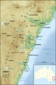
Map of the Sydney Basin
|
|||||||||||||||

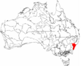
The interim Australian bioregions,
with the Sydney Basin in red |
|||||||||||||||
| Population | 5,000,000 | ||||||||||||||
| • Density | 78/km2 (200/sq mi) | ||||||||||||||
| Area | 64,000 km2 (24,710.5 sq mi) | ||||||||||||||
|
|||||||||||||||
|
|||||||||||||||
The Sydney Basin is a special natural area, or bioregion, located on the east coast of New South Wales, Australia. It's like a giant bowl-shaped landform, named after the city of Sydney which sits right in its middle. Part of this basin even extends under the Tasman Sea.
This huge area is about 5,000 meters (or 5 kilometers) deep. It's made up of sedimentary rocks from the Permian and Triassic periods, which are very old! The basin stretches from Newcastle in the north down to Batemans Bay in the south. To the west, it reaches the Great Dividing Range.
The Sydney Basin is home to major cities like Newcastle and Wollongong. It also has important reserves of coal, which is a valuable resource. The famous harbour in Sydney and the amazing cliffs of the Blue Mountains are made from the tough sandstone found in the basin. The Greater Blue Mountains Area within the basin is so special that it's a UNESCO World Heritage site.
Contents
What is the Sydney Basin?
The Sydney Basin is a large geological area in New South Wales, Australia. It's known for its unique landforms and rich history. This basin is a key part of Australia's natural landscape.
How Big is the Sydney Basin?
According to NSW Primary Industries, the basin follows about 350 kilometers of coastline. It goes from Newcastle in the north to Durras Lake in the south. The western edge runs through places like Lithgow and Ulan. In the north, it extends along the Liverpool Range before returning to the coast at Newcastle. To the east, the basin continues out to the edge of the continental shelf under the ocean.
The land part of the basin covers about 44,000 square kilometers. Another 5,000 square kilometers are offshore. The very center of the basin is about 30 kilometers west of the Sydney central business district near Fairfield.
The Australian Government's Department of the Environment and Energy sees the basin as an Australian bioregion. This means it's a large area with similar plants, animals, and ecosystems.
How the Sydney Basin Formed

The Sydney Basin was shaped over millions of years by geological processes. It's part of a much larger basin system that stretches over 1,500 kilometers. This system goes from the Bowen Basin in Queensland to the Gunnedah Basin in NSW.
Volcanic Activity and Sediment Layers
Some minor volcanic activity happened in the basin long ago. This was during the Early Jurassic (about 210 million years ago) and later periods. For example, the Prospect dolerite rock at Prospect Hill was formed during the Early Jurassic.
The basin contains thick layers of Permian and Triassic sediments. These layers can be up to 4,500 meters thick on land and 6,000 meters thick offshore. These sediments were laid down on top of older rocks.
The Basin's Uplift and Erosion
The basin formed when the Earth's crust stretched in the Early Permian period. Later, in the Late Permian, the land was pushed up. This created deeper areas where marine fossils are well-preserved. These areas filled with volcanic ash and sediments that formed the Newcastle Coal Measures.
In the Triassic period, the offshore part of the basin was lifted. This caused rivers to rework the Permian sediments. The basin then went through a final stage of pushing up in the Middle Triassic. It became dry land, and erosion has been shaping it ever since.
The breaking apart of the Tasman Sea in the Late Cretaceous period created the eastern edge of the basin we see today. In the south and west, the basin ends in dramatic cliffs made of sandstone and conglomerate. Many waterfalls can be seen on these cliff faces.
Timeline of the Sydney Basin's Formation

- Permian (299–252 million years ago): This was a time when swamp forests grew and died. Over millions of years, these plants turned into the huge coal deposits we find today. Australia's coal is younger than the coal found in the Northern Hemisphere.
- Early Triassic (252–247 million years ago): Dark, carbon-rich Narrabeen shales were formed. You can see these rocks at Long Reef and Narrabeen. At this time, Australia was part of the supercontinent Gondwana. The Sydney Basin was a place where sediments were deposited. The Ashfield Shale shows how river flows changed, depositing fine sands and muds in a river delta on a shallow sea shore.
- Mid Triassic (247–235 million years ago): A massive river, much bigger than the Amazon, flowed into the Sydney Basin. This river started in what is now Antarctica. It deposited mostly silica sand with some clay. Plant fossils are rare, but some fish fossils can be found in the clay layers.
- Late Triassic (235–201 million years ago): As the mountains eroded and the river slowed, finer shales were laid down. These rock layers are rich in Glossopteris fern fossils.
- End of Triassic (201 million years ago): The Lapstone fault moved, causing the Blue Mountains to rise. The western Sydney plain dropped, becoming flat land. The Sydney CBD area was pushed upwards.
- Jurassic (201–145 million years ago): Erosion continued, leaving Ashfield Shales on top. Deep V-shaped valleys formed in the Hawkesbury sandstone. Volcanic intrusions created places like Prospect Quarry, Mount Tomah, Mount Wilson, and Hornsby Quarry.
- Cainozoic (66 million years ago to present): The supercontinent Gondwana broke apart. Australia began to drift, and Sydney's rocks were lifted, tilted, and then eroded by weather. The sedimentary rocks were shaped into a landscape of bedrock valleys and a raised plateau. Sydney's largest rivers, like the Hawkesbury, Parramatta, Georges, and Hacking Rivers, carved deep valleys. During this time, the Ashfield Shale weathered to create flatter land with fertile soils. This was a big contrast to the cliffs and gorges in the sandstone areas. The Botany Bay Basin also formed, filled with sand.
- Late Pleistocene (12,000 years ago): After the last ice age, sea levels rose. This flooded Sydney's river valleys, creating the estuaries and deep harbours we see today.
Water Systems of the Sydney Basin
The Sydney Basin has three main drainage basins. These are areas where all the rain and river water flows into a common outlet. These basins are mostly or entirely within the Sydney Basin's geography.
- The Central Coast catchment.
- The Hawkesbury-Nepean catchment.
- The Sydney Metropolitan catchment.
Some rivers from other larger catchments also flow through the basin. For example, the Hunter River sub-catchment forms the northern border of the basin. In the south, the Illawarra and Shoalhaven sub-catchments form the southern border.
Images for kids
-
Map of the Sydney Basin
-
The interim Australian bioregions, with the Sydney Basin in red
-
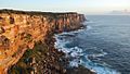
The Sydney Basin is mostly a raised sandstone plateau, except for the Hunter Valley and the flat Cumberland Plain.
-
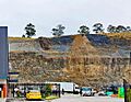
The Prospect dolerite rock at Greater Western Sydney
See also
 In Spanish: Cuenca de Sídney para niños
