
Parramatta River facts for kids
Quick facts for kids Parramatta River |
|
|---|---|

Parramatta River as it heads to Port Jackson, with the Sydney CBD visible in the background
|
|

NASA satellite view of Greater Metropolitan Sydney, with the location of the mouth of the Parramatta River, as it flows into Port Jackson, as marked
|
|
| Country | Australia |
| State | New South Wales |
| LGAs | Parramatta, Ryde, Canada Bay, Hunter's Hill, Inner West |
| Physical characteristics | |
| Main source | Toongabbie Creek Old Toongabbie 33°47′56″S 150°59′47″E / 33.798813°S 150.996350°E |
| 2nd source | Darling Mills Creek North Parramatta |
| River mouth | Port Jackson Greenwich and Birchgrove 33°50′41″S 151°10′55″E / 33.844654°S 151.181859°E |
| Length | 13.7 km (8.5 mi) |
| Basin features | |
| Basin size | 252.4 km2 (97.5 sq mi) |
| Tributaries |
|
The Parramatta River is a special kind of river mouth, called an estuary, in Sydney, New South Wales, Australia. It's where the river meets the ocean, and the tides have a big effect on it.
It's about 5.1 meters deep on average. The Parramatta River is the main river that flows into Sydney Harbour, which is part of Port Jackson. Smaller rivers like the Lane Cove and Duck rivers also flow into it.
The river starts where Toongabbie Creek and Darling Mills Creek meet in North Parramatta. It then flows east towards Port Jackson. The river's total catchment area (the land where all its water comes from) is about 252.4 square kilometers. The tides affect the river all the way up to Charles Street Weir in Parramatta.
For thousands of years, Aboriginal peoples lived along the Parramatta River. These included the Wallumettagal nations and clans of the Darug people. They used the river for food and trade. The river itself was formed millions of years ago when its waters carved a valley into the sandstone and shale.
Contents
Rivers and Creeks Flowing into Parramatta River
The Parramatta River begins where Darling Mills Creek and Toongabbie Creek join together. Toongabbie Creek also has a smaller branch called Greystanes Creek. This meeting point is near the suburbs of Westmead, Northmead, and North Parramatta.
Here are some of the other waterways that flow into the Parramatta River, listed from west to east:
- Vineyard Creek at Rydalmere (from the north)
- Ponds Subiaco Creek at Rydalmere (from the north)
- Duck River at Silverwater (from the south)
- Archer Creek at Meadowbank (from the north)
- Smalls Creek at Meadowbank (from the far north)
- Charity Creek at Meadowbank (from the north)
- Haslams Creek at Homebush Bay (from the south)
- Powells Creek at Homebush Bay (from the south)
- Iron Cove Creek at Five Dock (from the south)
- Hawthorne Canal at Iron Cove (from the south)
- Tarban Creek at Huntleys Point (from the north)
- Lane Cove River at Greenwich (from the north)
The River in Parramatta City

The Parramatta River starts in North Parramatta and flows south through the Cumberland Hospital grounds. It then turns east and goes through the center of Parramatta city. You can walk along most of the riverbanks, as there are parks and walkways. Many small creeks and stormwater drains also feed into the river.
The river's flow is controlled by several weirs (small dams). These include the weir at the hospital, the Kiosk Weir, Marsden Street Weir, and Charles Street Weir. These weirs have special "fish ladders" to help fish move up and down the river. Kiosk Weir and Charles Street Weir also have footbridges for people to cross.
In the past, the river was dammed to create water supplies for the town. Today, the weirs help keep water in the river during dry times, making it look nice. However, this can cause the river to flood when there is heavy rain, especially near the Charles Street Weir. This weir also marks the spot where fresh water meets salt water and where the tides stop.
Managing the River

The entire Sydney Harbour area, including the Parramatta River, has a long-term plan to manage its environment. The New South Wales Government is in charge of policies about public access to the riverbanks. This includes areas that are exposed at low tide.
Things like boat moorings and jetties are managed by Transport for NSW. They also look after the riverbed itself. Many bays have private boat moorings, and some are part of commercial marinas.
Many groups are working together to make the Parramatta River clean enough to swim in again by 2025. This effort started with Lake Parramatta opening for swimming in 2014. Thirteen local councils in the Parramatta River area are committed to reducing pollution from sewer overflows and stormwater.
Getting Around: Transport on the River
Ferry Services and Wharves
There are ferry services called River Cats that travel along the Parramatta River to Circular Quay. Here are the main ferry stops, from west to east:
| Wharf name | Suburb | Location on side of river | Image |
|---|---|---|---|
| Parramatta ferry wharf | Parramatta | Southern |  |
| Rydalmere ferry wharf | Rydalmere | Northern |  |
| Sydney Olympic Park ferry wharf | Wentworth Point | Southern |  |
| Meadowbank ferry wharf | Meadowbank | Northern |  |
| Kissing Point ferry wharf | Kissing Point | Northern |  |
| Cabarita ferry wharf | Cabarita Park | Southern |  |
| Abbotsford ferry wharf | Abbotsford | Southern |  |
| Chiswick ferry wharf | Chiswick | Southern |  |
| Huntleys Point ferry wharf | Gladesville | Northern |  |
River Crossings
The Parramatta River and Sydney Harbour divide Sydney in half. This means that bridges and other crossings are very important for connecting different parts of the city. Here are some of the crossings over the Parramatta River, from west to east:
| Crossing name | Southern location | Northern location | What it's used for | Image |
|---|---|---|---|---|
| Bridge Road | Westmead | North Parramatta | For cars and other vehicles. | |
| A new bridge next to Bridge Road for the Parramatta Light Rail. It carries the Light Rail and a shared path for walking and cycling. | ||||
| Ross Street Weir | Parramatta | For vehicles, but with limited access. | ||
| Buttons Bridge | Parramatta | For bicycles and people walking in Parramatta Park. | ||
| Noller Bridge | Parramatta | For bicycles and people walking in Parramatta Park. | ||
| Rings Bridge | Parramatta | A bridge for cars and people walking along O'Connell Street. | ||
| Marsden Street Weir | Parramatta | Used to carry Marsden Street, but a new bridge replaced it in 1971 due to flooding. It still connects to Marsden Street but has limited access. | ||
| Bernie Banton Bridge | Parramatta | A concrete bridge for cars and people walking along Marsden Street. It was built in 1971 and renamed in 2006 to honor Bernie Banton, who fought for people with asbestos diseases. | _(30181648790).jpg) |
|
| Lennox Bridge | Parramatta | A stone bridge built by convicts between 1836 and 1839. It now carries the Parramatta Light Rail and pedestrians. |  |
|
| Barry Wilde Bridge | Parramatta | Carries cars, buses, and footpaths along Wilde Avenue. | ||
| Elizabeth Street Footbridge | Parramatta | A bridge just for people walking, with an artwork called Wake. |  |
|
| Charles Street Weir | Parramatta | For people walking. It also gives access to the Parramatta Ferry Wharf. | ||
| The Macarthur Bridge | Parramatta | Built in 1885, this historic iron bridge is for cars and people walking along Macarthur Street. | _(30363328152).jpg) |
|
| Arthur Street Bridge | Parramatta | Completed in 2023, this bridge is for people walking and cycling. It's Australia's first diagonal arch bridge and connects to the Parramatta Valley cycleway. |  |
|
| James Ruse Drive bridge | Parramatta | A concrete road bridge for cars and people walking along James Ruse Drive. | .jpg) |
|
| Camellia | Rydalmere | Carries water pipes, next to an old rail bridge. | ||
| Carlingford railway bridge | Camellia | Rydalmere | Used to carry the Carlingford railway line. It's now part of the Parramatta Light Rail for walking and cycling. | .jpg) |
| Camellia | Rydalmere | A new bridge built for the second track of the Parramatta Light Rail. | ||
| Thackeray Street Bridge | Camellia | Rydalmere | A bridge for people walking, also carrying water pipes. It connects to the Parramatta Valley cycleway. |
|
| Silverwater Bridge | Silverwater | Rydalmere | A concrete road bridge for cars and people walking along Silverwater Road, opened in 1962. |  |
| John Whitton Bridge | Rhodes | Meadowbank | A railway bridge for the Main Northern railway line. |  |
| Meadowbank Railway Bridge | Rhodes | Meadowbank | Used to carry the Main Northern railway line until 1980. Now used by people walking and cycling. |  |
| Ryde Bridge | Rhodes | Ryde | A double bridge for cars and people walking along Concord Road. |  |
| Mortlake Ferry | align="center" |Mortlake | Putney | A cable ferry for cars and passengers, running since 1928. |  |
| Gladesville Bridge | Drummoyne (south–east) |
Huntleys Point (north–west) |
Completed in 1964, this concrete arch bridge carries cars and people walking along Victoria Road. It replaced an older bridge from 1881. |  |
.jpg)
River Health and Environment
Water Quality Concerns

Before 1970, the river was used as a drain for Sydney's industries. Because of this, some parts of the river, especially the southern bays, are still polluted with heavy metals and chemicals. The northern bays are less affected because industrial development happened later.
Experts from the University of Sydney have shown that Sydney Harbour is as polluted as other industrial city harbors. The worst pollution is in the southern central bays, from Blackwattle to Homebush Bays. Four of the five most polluted areas in Sydney Harbour are in the Parramatta River system.
The main polluted areas of the Parramatta River include:
- Homebush Bay: This area has dioxins, lead, and other chemicals. These came from nearby chemical factories like Berger Paints, CSR Chemicals, ICI/Orica, and Union Carbide.
- Iron Cove: This area has various metals and chemicals, but it's not clear where they all came from. Pollution might enter through Iron Cove Creek and Hawthorne Canal.
- Near the old AGL site, which is now the Breakfast Point area.
The Office of Environment and Heritage (New South Wales) (OEH) checks water quality for bacteria like E. coli, but only as far west as Cabarita. They don't check further west, even though more buildings are being built and people use the river for boating there. In the areas that are checked, the water is usually good, except after heavy rains.
Fishing Rules
Fishing is banned in some parts of the Parramatta River because of polluted sediments. There's a complete fishing ban in Homebush Bay due to dioxin pollution. In 2006, the NSW Government banned all commercial fishing in Sydney Harbour and its rivers west of the Harbour Bridge. This ban lasted until 2011.
Important Wetlands and Natural Areas
Important wetlands along the river include:
- Bicentennial Park Wetlands (important for migratory birds)
- Newington Wetlands (also important for migratory birds)
There are many mangrove trees along the river, especially west of Henley and Mortlake. Mangroves have grown in areas that used to be salt marshes. Old drawings show that there were fewer mangroves when Europeans first arrived. Land clearing and development have caused soil and nutrients to wash into the river, which helps mangroves grow. Too much silt in the river is still a problem.
Land Reclamation
Many parts of the river, especially swampy areas at the ends of bays, have been "reclaimed." This means land was created by filling in water areas, often with rubbish, before turning them into parks. Large parts of Meadowbank Park were made this way. Some industrial sites were also built on reclaimed land in Homebush Bay. Most creeks flowing into the bays have been "channelized," meaning they have concrete walls and floors.
Cleaning Up the River
Some areas of the river with very polluted sediments haven't been cleaned up yet. However, a big cleanup of sediments is starting in Homebush Bay. This includes removing dioxin-polluted sediments near the old Union Carbide plant and lead-polluted sediments near the old Berger Paints plant. The former AGL site has been checked, and a cleanup plan was approved and completed. However, the sediments there, which research shows are polluted, are still being investigated.
In some places, polluted sediments have been covered with concrete to stop fish from eating them. Some companies say it's best to leave the pollution alone, but environmental groups argue that the pollution could be moving up the food chain and that companies are trying to avoid cleanup costs.
Fun Activities on the River
Sailing
There are several sailing and yachting clubs on the Parramatta River:
- Abbotsford 12 ft Flying Squadron in Abbotsford
- Concord & Ryde Sailing Club at Putney
- Parramatta River Sailing Club at Gladesville
Sailing and rowing activities need a special license each year from Roads and Maritime Services.
Sea Scouts
Sea Scouts groups are located at:
- Rhodes: First Yaralla
- Meadowbank: Epping Scout Group has a boat shed and uses it for sailing and canoeing in summer.
Rowing
The river has a long history with rowing. There's a monument in honor of Henry Searle, a famous rower, in the river at Henley.
Some schools with rowing sheds on the river include:
- MLC School
- The King's School
- Sydney Boys High School
- Newington College
- The Scots College
- Sydney Grammar School
- Shore School
There are also many rowing clubs:
- Leichhardt Rowing Club, Drummoyne Rowing Club and UTS Haberfield in Iron Cove.
- Glebe Rowing Club in Blackwattle Bay.
- Sydney Rowing Club at Abbotsford Point.
- Balmain Rowing Club at Balmain
- UNSW Boat Club in Tarban Creek.
- SGHS Rowing Club also in Tarban Creek.
While some rowing races are still held on the river, many big events now take place at the Sydney International Regatta Centre (SIRC) near the Nepean River. This is where rowing events for the 2000 Summer Olympics were held.
Most rowing training happens in the middle and upper parts of the river, between Abbotsford and Homebush Bay. This area has less boat traffic, fewer waves, and more protection from the wind. Rowing also takes place in the Lane Cove River and Iron Cove.
Walks and Cycleways
Many parts of the riverbank are still private property or industrial sites. However, more and more waterfront land is becoming public parkland with walkways and cycleways. As old industrial sites are cleaned up and redeveloped, their riverfronts are opened to the public. Where there isn't direct river access, cycleways go through quiet streets marked for cyclists.
Major parks along the river include:
- Cabarita Park
- Kissing Point Park, Ryde
- Meadowbank Park
- Putney Park
- George Kendall Riverside Park, Ermington
- Bicentennial Park, Homebush Bay
- Millennium Parklands, Homebush/Auburn
Historic Buildings

Several important historic buildings are located on or near the river, all listed on the Register of the National Estate:
- Thomas Walker Convalescent Hospital (now Rivendell Child, Adolescent and Family Unit): Designed by Sir John Sulman and built in 1891–93.
- Callan Park: A former hospital with beautiful sandstone buildings designed by James Barnet in 1877.
- Gladesville Mental Hospital: Features sandstone buildings in a park-like setting, designed by Mortimer Lewis in 1836.
- Yaralla: The large mansion of Thomas Walker and his daughter Dame Eadith Walker. It was built in the late 1860s and later expanded. It now serves as Dame Eadith Walker Hospital.
- Newington House: A Regency-style home built in 1832 by John Blaxland. It later became Newington College and then part of Silverwater State Hospital. It is now an administrative building in the Silverwater Correctional Complex.
Gallery
-
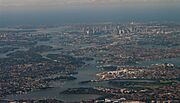
Aerial view across the mouth of the river as it reaches in Port Jackson
-
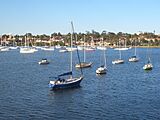
Parramatta River at Five Dock Bay, Drummoyne
-
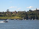
Parramatta River at Gladesville
-
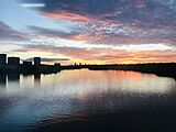
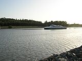
Sunset on the Parramatta River seen from John Whitton Bridge, Meadowbank
-
Parramatta River at Ermington
-
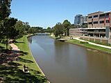
Parramatta River at Parramatta


See also
 In Spanish: Río Parramatta para niños
- List of rivers of New South Wales (L-Z)
- Rivers of New South Wales
- Geography of Sydney
- Guide to Sydney Rivers site
