
Iron Cove facts for kids
Quick facts for kids Iron Cove |
|
|---|---|

Iron Cove information plate
|
|

Iron Cove
Location in Sydney
|
|
| Coordinates | 33°51′45″S 151°09′17″E / 33.862425°S 151.154812°E |
| Type | Estuarine bay |
| Part of | Port Jackson |
| Primary inflows | |
| Primary outflows | Parramatta River |
| Catchment area | Sydney Basin |
| Basin countries | Australia |
| Frozen | never |
| Islands | Rodd Island |
| Settlements | Sydney |
Iron Cove is a pretty bay located in the inner-west part of Sydney, New South Wales, Australia. It is part of the larger Parramatta River system. This bay is about 5 kilometres (3.1 mi) west of Sydney's main city area.
Many suburbs surround Iron Cove. These include Birchgrove, Balmain, Rozelle, Lilyfield, Haberfield, Five Dock, Rodd Point, Russell Lea, and Drummoyne. The bay stretches from Longnose Point in the south-west. Water flows into Iron Cove from the Hawthorne Canal and the Iron Cove Creek.
History of Iron Cove
The original name for this area was Go-mo-ra. This name was recorded by William Dawes. It was the name used by the local Aboriginal people.
In the early days of the New South Wales colony, the bay was sometimes called Long Cove. This was probably because of its long, narrow shape. The exact reason for the name 'Iron Cove' is not fully clear. On an old map from 1822, it was called Iron-stone Cove. 'Iron Cove' might be a shorter version of this name. It could refer to the reddish iron in the rocks found there.
One idea is that the name came from the iron chains worn by people who worked in the area. These people were from Cockatoo Island starting in 1839. Another idea is that the name came from the Ironbark trees. These trees used to grow around the bay.
Important Features of the Bay
There is an island in the middle of Iron Cove called Rodd Island. It is named after Brent Clements Rodd. The bay is crossed by the Iron Cove Bridge. This bridge first opened in 1882. It connects the suburbs of Rozelle and Balmain to Drummoyne. The first bridge was later replaced in the 1950s.
In 1953, two Australian warships were taken apart for scrap metal in the bay. These ships were HMAS Ballarat and HMAS Goulburn.
Iron Cove has smaller bays within it. These include Sisters Bay and Half Moon Bay on its northern side. The Iron Cove Creek flows into the western end of the bay. The Hawthorne Canal connects to the southern part of the bay.
Most of the land around Iron Cove is public parkland. This area forms a 7 kilometres (4.3 mi) path. It is a popular place for jogging and is known as The Bay Run.
Pollution in Iron Cove
Iron Cove and its surrounding area have faced pollution challenges. Experts from the University of Sydney say it has been one of the most polluted areas in Sydney Harbour. High levels of metals like copper, zinc, and lead have been found in the bay.
Some of this pollution comes from road dust. This dust is washed into the bay by stormwater when it rains. The Iron Cove Creek also has other types of pollution.
There is a plan to install a special water filter at Iron Cove Creek. This device would help stop harmful materials from reaching Sydney Harbour.
Gallery
-
Dobroyd Point, Iron Cove from Francis Street, Lilyfield
-
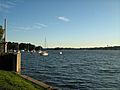
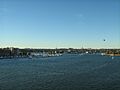
View of Iron Cove from King George Park, Rozelle
-
Rodd Island looking north from Rodd Point
-
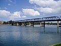
Iron Cove Bridge with Lilyfield in background, taken from Birkenhead Point
-
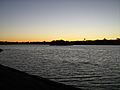
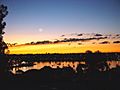
Looking over Iron Cove from Callan Park at dusk
-
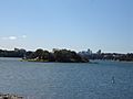
Looking towards the head of Iron Cove with Cockatoo Island in the distance


