
Iron Cove Creek facts for kids
Quick facts for kids Iron Cove |
|
|---|---|

Iron Cove Creek looking towards Iron Cove.
|
|
| Country | Australia |
| State | New South Wales |
| Municipality | Sydney |
| Physical characteristics | |
| Main source | Ashfield Park Ashfield 33°53′20″S 151°7′30″E / 33.88889°S 151.12500°E |
| River mouth | Parramatta River Iron Cove 33°52′13.4862″S 151°8′31.02″E / 33.870412833°S 151.1419500°E |
| Basin features | |
| River system | Parramatta River |
Iron Cove Creek is a small waterway in Sydney, Australia. It is also known as the Dobroyd Stormwater Channel. This creek flows through inner-western suburbs like Croydon, Ashfield, Haberfield, and Five Dock. It is a branch of the Parramatta River.
The creek mostly runs through neighborhoods and parks. It travels about 2 kilometers from where it starts in Croydon. It then flows into Iron Cove, which is a part of the Parramatta River, at Five Dock. The creek also forms a boundary between Croydon and Ashfield. Long ago, Iron Cove Creek was a natural stream with lots of plants and animals. But in the late 1800s, it was changed into a channel to drain rainwater. This helps manage water in Sydney's inner-western areas.
Contents
History of Iron Cove Creek
How the Creek Changed Over Time
In the 1860s, Iron Cove Creek was a free-flowing stream. Some parts of it were wide ponds, perfect for swimming. Many water birds and snakes lived here. Possums and gliders were also common in the trees.
By the 1890s, the creek looked very different. People started to see the creek as a problem. It would flood when it rained a lot. During dry times, the water would become still and dirty. This led to health issues like typhoid fever. So, plans were made to line the creek banks with concrete.
Building the Stormwater Channel
Major construction work began in 1891. The Department of Public Works built the new banks. William Best Chessell, a local resident, oversaw the project. It took five years to finish. This work changed Croydon a lot.
In his book, Between Two Highways: the story of early Croydon, Eric Dunlop explains the changes. He wrote that because of the new canals and tunnels:
the waters now drained away quickly, the swamps and pools disappeared, and as the banks of the main stream were filled in and leveled to the edges of the canal its wooded foreshores vanished and more land became available for settlement.
This meant the water flowed faster, and wet areas dried up. More land became available for building homes.
Iron Cove Creek's Path Today
From Croydon to Parramatta Road
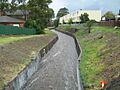
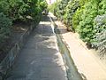
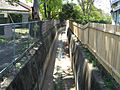
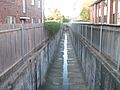
Iron Cove Creek starts as a small stream in Croydon. It appears from a stormwater tunnel near Norton Street. From there, it flows through a narrow concrete channel. This channel has high walls on both sides. It goes under the Main Suburban railway line. In dry weather, it's just a small trickle here. Fences from homes and businesses line the canal. It is mostly hidden from public view.
Wider Sections and Parkland
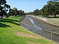
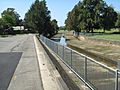
The creek changes when it reaches the John Street bridge. The concrete channel becomes much wider. The banks are also much lower. From John Street to West Street, the creek has wide grassy areas. These areas have different types of plants. There is space for a walking or cycling path next to the creek. There is also room to plant native trees and plants.
About 100 meters downstream from West Street is the Parramatta Road bridge. This is roughly where the tide affects the creek. Near the creek on Parramatta Road, you can find popular fast-food restaurants, a council depot, and a service station.
Flowing into Iron Cove
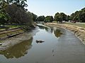
After passing under the Parramatta Road bridge, Iron Cove Creek enters public parkland. It becomes a wide channel, likely similar to its original width. Parkland is on the right side. Henley Marine Drive runs parallel to the creek on the left. The creek then goes under Ramsay Street. It widens even more and flows through parks, including Timbrell Park.
The water level here changes a lot with the tides. The tide affects the creek up to 100 meters upstream of Parramatta Road. You might even see mullet fish in the lower parts of the creek during high tide.
The creek flows into Iron Cove as a wide canal. This is at the intersection of Timbrell Drive and Dobroyd Parade in Five Dock. There is a floating barrier across the creek here. Its job is to stop pollution from entering Sydney Harbour.
Between Parramatta Road and Iron Cove, the creek forms part of the boundary for federal voting areas. These are the electoral divisions of Reid and Grayndler.
Church Street Bridge
The Church Street bridge crosses Iron Cove Creek. It is on the border of Croydon and Ashfield. The bridge is made of sandstone, brick, and steel. The path of Church Street was first used by people from Burwood. They would cross the creek on a large fallen tree to get to St John's Ashfield church.
-
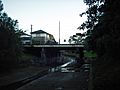
Iron Cove Creek and the Church St bridge looking upstream
-

Under the Church Street bridge
-
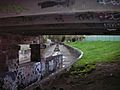
Under the Church St bridge and Iron Cove Creek
-
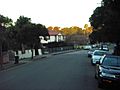
View of Church Street looking over Iron Cove Creek from Croydon into Ashfield


Pollution in Iron Cove Creek
Sources and Impact of Pollution
Pollution flowing into Iron Cove from Iron Cove Creek is a big environmental problem. Things like heavy metals, asphalt, road dust, and various nutrients wash into the creek when it rains. This problem is made worse because popular fast-food restaurants and a service station are right next to the creek on Parramatta Road. Also, the concrete lining of the creek stops natural plants like mangroves from growing. These plants usually help keep the water clean.
Iron Cove Creek carries water and dirt that have high levels of copper, lead, and zinc. These flow into Iron Cove when the water flow is low. The creek is a main source of these harmful materials. As the water in the lower creek becomes saltier, it affects how much copper, lead, and zinc stay in the water versus sticking to particles.
Pollution might enter Iron Cove more during long periods of low water flow. During heavy rains, the polluted material quickly leaves the estuary in a top layer of water. This unusual feature might offer ways to clean up stormwater before it enters Port Jackson.
Images for kids
-
Iron Cove Creek flowing swiftly after a thunderstorm. Looking upstream from the Church Street bridge, Croydon, NSW.
-
A rapid Iron Cove Creek flowing downstream from the John St bridge after a thunderstorm, Ashfield, NSW.
-
The lower reaches of Iron Cove Creek beside Dobroyd Pde, Five Dock at low tide.
-
Iron Cove Creek looking downstream at low tide from Ramsay St, Five Dock.
-
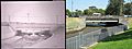
The Iron Cove Creek bridge on Ramsay Street at Five Dock showing contrasting views of the same location in 1931 and in 2007.
-
Iron Cove Creek sandwiched between Henley Marine Drive and Wadim (Bill) Jegorow Reserve about 200 metres downstream from Parramatta Road.
-
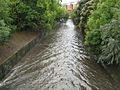
Iron Cove Creek looking downstream from the Church Street bridge after a thunderstorm.
-
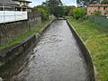
Looking downstream from the Church Street bridge during dry weather.
-
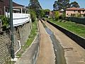
Looking upstream from the Church Street bridge during dry weather.
-
A narrow Iron Cove Creek at the end of Gregory St, Croydon.
-
The upper most reaches of Iron Cove Creek viewed from Thomas Street, Croydon.


