
Ashfield, New South Wales facts for kids
Quick facts for kids AshfieldSydney, New South Wales |
|||||||||||||||
|---|---|---|---|---|---|---|---|---|---|---|---|---|---|---|---|
.jpg)
Liverpool Road
|
|||||||||||||||
| Population | 23,012 (2021 census) | ||||||||||||||
| • Density | 6,748/km2 (17,480/sq mi) | ||||||||||||||
| Established | 1838 | ||||||||||||||
| Postcode(s) | 2131 | ||||||||||||||
| Elevation | 34 m (112 ft) | ||||||||||||||
| Area | 3.41 km2 (1.3 sq mi) | ||||||||||||||
| Location | 8 km (5 mi) west of Sydney central business district | ||||||||||||||
| LGA(s) | Inner West Council | ||||||||||||||
| State electorate(s) |
|
||||||||||||||
| Federal Division(s) | |||||||||||||||
|
|||||||||||||||

Ashfield is a busy suburb located in the Inner West part of Sydney, New South Wales, Australia. It's about 8 kilometres west of the main city centre.
Ashfield is known for its many different cultures, with people from all over the world living there. Most homes are a mix of modern apartment blocks and older, beautiful houses built in the Federation style. You can also spot some grand Victorian buildings, which show Ashfield's long and interesting history.
Contents
History
Who lived here first?
Before British settlers arrived, the land where Ashfield now stands was home to the Wangal people. Their traditional country was around Concord and stretched east towards Long Cove Creek, which is now called Hawthorne Canal. The area was covered in thick forests with tall eucalypt trees and swampy plants near the creeks. The Wangal people hunted native animals and fished in the waters. When the First Fleet arrived in 1788, it had a terrible effect on the local people, mainly because of diseases like smallpox that they had no protection against.
Early British settlement
By 1790, a rough path connected the two main British settlements: Sydney Cove and Parramatta. This path later became a major road and formed the northern edge of Ashfield, guiding where the first British settlers built their homes. The very first piece of land was given to Rev Richard Johnson in 1793. By the 1820s, all the smaller land grants had become two big estates: Ashfield Park (north of Liverpool Road) and Canterbury Estate (south of Liverpool Road). Ashfield Park was named by Robert Campbell, whose father came from a place called Ashfield in Scotland.
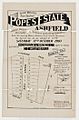
Old maps of Ashfield
-
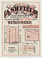
Choice Villa Sites, Ashfield, 1876
-
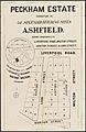
Peckham Estate, Ashfield, 1881
-
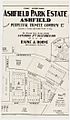
Ashfield Park Estate, 1904
-
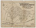
Village of Ashfield, 1879
-
Pope's Estate, Ashfield, 1903
-
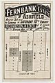
Fernbank Estate Ashfield, 1907
-
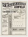
St Regulus Estate Ashfield, 1907
-
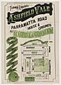
Ashfield Vale, c. 1910


How Ashfield grew
In 1838, Elizabeth Underwood, who owned Ashfield Park, divided some of her land to create the village of Ashfield. She also set aside land for St John's Church, built in 1841, which is the oldest building still standing in Ashfield. By 1855, the village had about 70 houses and 200 people.
However, everything changed when the Sydney-Parramatta railway line opened in 1855, with Ashfield as one of its first stations. This caused the population to grow very quickly! By 1872, there were enough residents for Ashfield to get its own municipal council. By 1890, the population had reached 11,000.
In the late 1800s, Ashfield was a popular place to live, especially for wealthy families who wanted to escape the crowded city. Many grand Victorian houses were built. But after World War I, many rich residents moved to the North Shore. In the 1920s and 1930s, many large homes were replaced with smaller art deco apartment blocks or semi-detached houses.
By the 1950s, Ashfield's population started to drop as people moved to newer homes further from the city. To encourage growth, the Council began approving more apartment buildings, a trend that continues today. However, many older buildings are now protected to preserve Ashfield's history.
Ashfield's factories


Even though Ashfield wasn't a major industrial area, it had a few important factories. The Australian Six car factory opened in 1920 on Parramatta Road. Later, this site became an AWA factory that made radio parts. Today, it's a mix of shops and homes.
Across the street was the Peek Freans biscuit factory. Its tall tower was a familiar sight for drivers on Parramatta Road. This factory is also no longer making biscuits; it's now a large Bunnings warehouse.
Shopping and Business
Ashfield's main shopping area is along Liverpool Road, south of Ashfield railway station. Here, you'll find office buildings, many shops, and Ashfield Mall. This mall has supermarkets, a discount department store, and smaller specialty shops. The shopping area also spreads into Charlotte Street and Elizabeth Street, north of the station.
Another business area is along Parramatta Road, mostly with car-related shops and small factories.
Getting Around
Ashfield is located where two major roads meet. Parramatta Road goes from Sydney city to Parramatta, and then becomes the Great Western Highway. Liverpool Road goes from Parramatta Road in Ashfield to Liverpool, and then becomes the Hume Highway. Even though new highways have been built, these roads are still busy and connect Ashfield to all parts of Sydney.

Ashfield railway station is on the Main Suburban railway line of the Sydney Trains network. It opened in 1855 as one of the first stations on the Sydney to Parramatta railway line. The station was updated in 2002. You can catch express or all-stations trains to the City Circle, Homebush, Parramatta, Leppington, and Liverpool.
Ashfield is also a hub for many Transit Systems bus services. Two routes (464 and 466) start here, going to Mortlake and Cabarita. Nine other bus routes pass through Ashfield, connecting it to places like Five Dock, Campsie, Burwood, and Hurstville.
While there aren't many special bicycle paths in Ashfield itself, a local cycling group has worked with the council to find good routes for cyclists. The route from Strathfield to Newtown is important, linking to popular cycleways like the Cooks River to Iron Cove Greenway.
Learning and Schools

Ashfield has three primary schools: Ashfield Public (on Liverpool Road), St Vincent's (a Catholic school on Bland Street), and Yeo Park Infants (on Victoria Street). There are also two high schools: Ashfield Boys High School (next to Ashfield Public) and St Vincent's College (a Catholic co-educational school on Bland Street, formed in 2023 by combining Bethlehem College and De La Salle College).
Ashfield Public is the oldest, opening in 1876 after local people asked for it. It became a "Superior School" in 1907, adding two years of high school. In 1965, Ashfield Boys High School officially became a separate school.
Bethlehem College was the first high school in the area, started by the Sisters of Charity in 1881. The De La Salle school opened in 1915.
An Anglican girls' boarding school called Normanhurst School was established in 1882. It closed in 1941. Famous students included Pamela Travers, who wrote the Mary Poppins books, and tennis champion Daphne Akhurst.
Cool Places to See

If you're passing through Ashfield, three main landmarks stand out: the tower of the old Peek Frean Biscuit factory (now Bunnings Warehouse) on Parramatta Road, Wests Leagues Club on Liverpool Road, and the Ashfield water reservoir in Holden Street. The water tower was built in 1912 and provides water for the surrounding areas.
Historic Houses
The Inner West Council has information about many important old buildings in Ashfield. Some of these include:
- Plynlimmon (built 1867) in Norton St, now a child care centre.
- Glenore (built 1897) and Buninyong (built 1901) in Tintern Road.
- Mountjoy (built 1870) in Victoria Street, now part of a hospital.
- Glentworth (built 1887) also in Victoria Street, now part of a retirement village.
- Ashfield Castle (built 1887) in Queen Street, originally called Ambleside.
- Thirning Villa (built 1868), now part of Pratten Park.
- Milton in Blackwood Avenue, built in the 1850s, once home to NSW Premier Sir Henry Parkes.
- Amesbury (built 1888) in Alt Street, with its impressive tower.
- Gorton in Henry Street, built in 1860, which has been the Infants Home since 1876.
Many of these properties, like Amesbury, Ashfield Castle, and Ashfield Park, are listed on the Register of the National Estate, meaning they are important heritage sites.
Churches


The first church in Ashfield was St. John the Baptist's Anglican Church in Alt Street. It was part of Elizabeth Underwood's plan for the village in 1838. Construction began in 1840, and it was finished in 1845. It's the oldest building still standing in Ashfield.
In 1842, a piece of land was set aside for a Methodist chapel and school. A larger building was built in 1864, which is now the Ashfield Uniting Church. It's also home to the Exodus Foundation, which helps people in need.
The Presbyterians built their first church in 1876 on Liverpool Road and Knox Street. The original church building was moved twice and is still there today.
Catholic services started in 1880 at Bethlehem College. As more people attended, a new church, St Vincents, was built in Bland Street, completed in 1907.
The Baptists first met in the School of Arts building. They later moved to their current site on Holden and Norton Streets, building a beautiful Gothic-style church with a landmark tower.
The Seventh-day Adventists have had a church in Ashfield for over 100 years, located on Charlotte Street.
Parks and Green Spaces


Ashfield Park on Parramatta Road is one of the largest public parks in inner west Sydney. It has tall phoenix palms, a war memorial, and a children's playground with a statue of Mary Poppins. This statue honours the author PL Travers, who lived nearby. The park also has a monument for International Mother Language Day, a statue of Filipino hero Jose Rizal, a sports field, and one of Sydney's oldest bowling clubs. The park is over 6 hectares in size.
The main sports ground in the area is Pratten Park. It's home to the Western Suburbs cricket club in summer and is used for soccer in winter. There are also tennis courts and a bowling club. Thirning Villa, located in the park, is home to the Ashfield District Historical Society and an artist-in-residence program.
Another sports field is Hammond Park on Frederick Street. It started as a private cricket ground in 1877. In 1888, it was supposed to be the site of Australia's first parachute jump from a hot air balloon, but the parachutist landed far away! This park also had an ice skating rink in the late 1800s.
Other notable parks include Yeo Park on the southern edge of Ashfield, which has a heritage-listed band rotunda, and Explorers Park on the corner of Parramatta Road and Liverpool Road. Explorers Park marks the spot where many early British explorers began their journeys west and south. It also features carvings from early Indigenous people in Sydney.
Swimming Pools
The Ashfield Olympic Swimming Centre first opened on 26 January 1963. It had an outdoor 50-metre pool, a diving pool, and children's pools. Later, a heated indoor 25-metre pool was added. The old pools and buildings were taken down in 2018.


The new Ashfield Aquatic Centre reopened on 17 October 2020 after a big redevelopment. It now has five new pools, including an outdoor 50-metre pool that's heated all year, a multipurpose outdoor pool with a floor that can change depth, an outdoor children's pool, an indoor 25-metre pool, and an indoor baby/toddler pool. It also has a gym, sauna, steam room, spa, and a cafe.
Local Government

Ashfield is part of the Inner West Council local government area in Sydney's Inner West.
For federal elections, Ashfield is in the electoral division of Grayndler, currently represented by Labor's Anthony Albanese.
For state elections, Ashfield is part of the Summer Hill electorate. Before 2015, it was split between the Strathfield and Canterbury electorates. From 1894 to 1999, there was a state electorate specifically called Ashfield.
People of Ashfield

| 2021 Census Ashfield | |||
|---|---|---|---|
| Ashfield | Sydney | Australia | |
| Population | 23,012 | 5,231,147 | 25,422,788 |
| Median age | 36 | 37 | 38 |
| Median weekly income | $1,888 | $2,077 | $1,746 |
| Born in Australia | 45% | 57% | 67% |
| Born in China | 12.2% | 4.6% | 2.2% |
| Living in free standing houses | 22% | 56% | 72% |
| Living in apartments | 70% | 31% | 14% |
In the 2021 census, Ashfield had 23,012 people living in an area of 3.5 square kilometres. The average age was 36, which is a little younger than the national average. The average household income was higher than the national average but slightly lower than for the wider Sydney area.
Ashfield is very multicultural. The most common backgrounds reported in 2021 were Chinese (22.1%), English (18.6%), and Australian (14.9%). About 45.4% of residents were born in Australia. Other common birthplaces include China (12.2%), Nepal (6.7%), and India (3.2%). While 46.0% of people only spoke English at home, many other languages are spoken, including Mandarin (12.5%), Nepali (6.8%), and Cantonese (5.3%).
When it comes to housing, Ashfield is different from the rest of Australia. About 70% of homes are flats (compared to only 14.2% nationally). Only 22.1% are detached houses. Also, more people in Ashfield rent their homes (50.5%) compared to owning them outright or buying them.
Famous People from Ashfield

Many notable people were born or lived in Ashfield, including:
- Daphne Akhurst (1903–1933): A five-time Australian Open tennis champion, born in Ashfield.
- Marjorie Barnard (1897-1987): A well-known writer.
- Robert Campbell (1769–1846): An early settler who gave Ashfield its name.
- Ian Clunies Ross (1899–1959): A veterinary scientist and founder of the CSIRO. He was once featured on the Australian $50 note.
- Rev Bill Crews (1946–): As the Minister of Ashfield Uniting Church, he started the Exodus Foundation to help young people who are homeless.
- Sir Henry Parkes (1815–1896): The 7th Premier of New South Wales and known as the "Father of Federation," he lived in Ashfield in the 1870s.
- Mei Quong Tart (1850–1903): A successful businessman and tea house owner in the late 1800s.
- P. L. Travers (1899–1996): The author of the Mary Poppins stories. She lived in Ashfield between 1918 and 1924.
Culture and Fun
Events

The biggest community event in Ashfield each year is the Carnival of Cultures. This festival celebrates the area's multiculturalism. Held every year since 1996 in Ashfield Park, it features performances, food stalls, and entertainment for children.
The Sydney Writers' Festival also holds some of its events in Ashfield as part of the "Authors at Ashfield" series, which is now known as the "speaker series" since the 2016 merger into the Inner West Council.
Arts
The Inner West Council supports community arts in Ashfield. This includes an artist-in-residence program at Thirning Villa in Pratten Park. The artists hold talks, workshops, and teach at local schools. In front of Thirning Villa, there's Ashfield's version of the Rosetta Stone, created by a former artist-in-residence. It features a passage from the Iliad by Homer in twelve different community languages.
Sports
Ashfield has a long connection with rugby league. The Western Suburbs Magpies rugby league team was formed in Ashfield in 1908 and played in the first New South Wales Rugby League competition. The club won its four championships while based at Pratten Park. Although the team later moved, the Wests Leagues Club has remained in Ashfield since 1908.
Ashfield also made cycling history in 1888 when it hosted the world's first women's cycling race. Dorothy Morrell won the two-mile (3 km) race.
Ashfield is home to Australia's first official cricket pitch, set up in 1875. It was later sold to the Ashfield Cricket Club and then to the Ashfield Council in 1910, who renamed it "Hammond Park" after former mayor Mark J. Hammond.
