
Cooks River facts for kids
Quick facts for kids Cooks River |
|
|---|---|

Cooks River near Sydney Airport
|
|

|
|
| Native name | Goolay'yari |
| Country | Australia |
| State | New South Wales |
| Region | Sydney basin (IBRA), Inner West |
| City | Sydney |
| Physical characteristics | |
| Main source | Graf Park Yagoona |
| River mouth | Botany Bay Kyeemagh 33°56′57″S 151°10′06″E / 33.94917°S 151.16833°E |
| Length | 23 km (14 mi) |
| Basin features | |
| River system | Botany Bay |
| Basin size | 100 km2 (39 sq mi) |
| Tributaries |
|
The Cooks River is a special waterway in south-eastern Sydney, Australia. It's like a long arm of the sea that flows into Botany Bay. This river is about 23 kilometers (14 miles) long.
The river's path has changed over time to make way for buildings and other developments. It helps carry stormwater (rainwater runoff) from a large area of 100 square kilometers (39 square miles). Many small streams that once fed the river are now concrete channels. However, the parts of the river affected by tides are home to many mangrove trees, birds, and fish. People also use these areas for fun activities.
Contents
Where Does the Cooks River Flow?
The Cooks River starts at Graf Park in Yagoona. It flows mostly northeast towards Chullora. The river then turns southeast. At Strathfield, it becomes a narrow concrete channel.
However, where the river goes through Strathfield Golf Course, some of the concrete has been removed. This has allowed plants to grow back. These plants help clean the water, and wildlife has returned to this area. One part here is even called the Chain of Ponds.
Near Belfield, the river joins with the Cox Creek Channel. It then flows east. The river gets wider and deeper as it collects stormwater from nearby suburbs like Campsie. At this point, the ocean's tides also start to affect the river.
At Canterbury, the Cup and Saucer Creek joins the Cooks River. In the past, factories in this area used to dump their waste directly into the river.
The river valley becomes more noticeable as it reaches Tempe. Here, Wolli Creek and the Alexandra Canal flow into it. The Princes Highway crosses the river here, connecting Tempe to Wolli Creek. There's also a small, low island called Fatima Island that gets covered by water at high tide.
The very last part of the river, which flows south, was changed by people. This was done to make space for the growing Sydney Airport. Finally, the Cooks River meets Botany Bay at Kyeemagh.
The land next to the river is used for many important services. These include electricity lines, oil pipes, and sewage pipes. Many low-lying areas have been filled in and are now parks or sports fields. Even with all these changes, people are starting to appreciate the river's beauty, history, and environmental importance. A walking and cycling path runs along much of the river. It connects Sydney Olympic Park to Botany Bay.
How the River is Looked After
Many groups work together to care for the Cooks River. These include several local councils and government agencies in New South Wales.
There are also community groups that help. One important group is The Cooks River Valley Association (CRVA). This group started in 1925 as The Cooks River Improvement League. They wanted to clean up the river.
Good things are happening to help the river. In 2010, the Cup and Saucer Wetlands were built in Canterbury. This created a natural home for local plants and animals. Also, some concrete parts of the river banks are being replaced with natural sandstone rocks and native plants.
Environmental Challenges
.jpg)
The Cooks River gets water from a large area of 100 square kilometers (39 square miles). This area is full of cities and towns in Sydney. Over 400,000 people live here, and there are many businesses and factories. Because of this, the river faces common problems found in busy city areas, such as:
- Loss of native plants and animal homes.
- Changes to how water flows, like more runoff from hard surfaces and concrete channels.
- Pollution from cars, trash, and illegal dumping.
- Too many nutrients from parks and gardens, which can cause too much algae to grow.
The Cooks River Alliance is a group of local councils working together. They help communities restore the river's health. The Alliance combines knowledge and skills to solve environmental problems. Local residents can also share their ideas and help guide the Alliance.
Tests have shown that the river water contains chemicals from medicines and industries. This is likely due to an old and damaged sewage system.
A project called Riverlife is funded by local councils. It trains guides who lead walking and cycling tours along the river. These tours help people learn about the river's environment.
History of the Cooks River
Before Europeans arrived, Indigenous Australians lived along the river. They fished and collected shellfish. Their way of life did not harm the river's natural environment. In the local Aboriginal languages, the Cooks River is called Goolay'yari, which means 'pelican'. Different Aboriginal clans lived around the river. The Bediagal clan lived on the south side. The Gameygal clan lived near the river's mouth. The Cadigal people lived further west, and the Wangal people lived along the upper parts of the river.
In 1770, Captain Cook sailed into Botany Bay. He wrote the first description of the river. He said he found "a very fine stream of fresh water." He thought the river might be a good place for a settlement. However, when the First Fleet arrived, they found the river was too shallow and had too many swamps.

Early land grants along the river were large. They were mostly used for grazing animals and cutting timber. Some people also fished or burned lime near Botany Bay. In 1810, Governor Macquarie mentioned a small bridge over the river. He also noted that the soil was not very good for farming. Still, some farmers did settle there, and roads and crossings were built.
In the 1830s, a dam was built across the river. But this dam did not provide clean water. It also started to harm the river by stopping the tides from washing away dirt. Another dam was built for a sugar mill in Canterbury Vale. The mill used the river for water and transport. The mill closed in 1855, but other polluting industries followed. These included wool washing, leather tanning, and boiling down works.
Even with the water getting worse, the river was still popular in the late 1800s. People enjoyed boating, picnics, and swimming. In 1894, artist Sydney Long painted a beautiful scene of boys swimming in the river. It was called By Tranquil Waters. By the 1880s, cutting down trees caused erosion and dirt to build up. This blocked the river's flow.
In May 1889, a huge flood hit the area. Over 425 millimeters (17 inches) of rain fell. The flood covered all the low-lying land. The authorities removed the dams and weirs because of the damage. A sewage farm operated near the river's mouth from 1889 to 1916.
In the 1930s, people started lining the river banks with concrete. The Cooks River Improvement Act of 1946 made this official. Engineers also changed the river's original mouth to make room for Sydney Airport runways.
Since 1976, efforts have been made to bring back the river's natural features. This includes planting trees, setting up pollution traps, and improving the landscape. Footpaths and a cycle track were built for people to enjoy the river. The NSW State Government has spent money to fix the river banks. In 2007, the Australian Labor Party promised A$2 million for environmental projects on the Cooks River.
In 2009, Strathfield Council started the Cooks River Fun Run. This event happens every year around June or July. It includes different races and walks for all ages.
Gallery
-
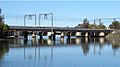
Cooks River, railway bridge between Tempe and Wolli Creek
-
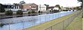
Industrial areas along the Cooks River at Canterbury
-
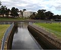
Cooks River joined by Cup and Saucer Creek
-
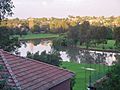
Cooks River at Hurlstone Park


