
Canterbury, New South Wales facts for kids
Quick facts for kids CanterburySydney, New South Wales |
|||||||||||||||
|---|---|---|---|---|---|---|---|---|---|---|---|---|---|---|---|

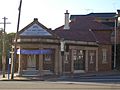
Canterbury Hotel, Canterbury Road
|
|||||||||||||||
| Population | 9,430 (2021 census) | ||||||||||||||
| Postcode(s) | 2193 | ||||||||||||||
| Elevation | 26 m (85 ft) | ||||||||||||||
| Location | 11 km (7 mi) South-west of Sydney CBD | ||||||||||||||
| LGA(s) | City of Canterbury-Bankstown | ||||||||||||||
| State electorate(s) | Canterbury | ||||||||||||||
| Federal Division(s) | |||||||||||||||
|
|||||||||||||||
Canterbury is a suburb in western Sydney, New South Wales, Australia. It is about 10.5 kilometres (6.5 miles) south-west of the Sydney central business district (CBD). Canterbury is part of the City of Canterbury-Bankstown.
The area used to be called the City of Canterbury. It was named after this suburb. However, its main office was in the nearby suburb of Campsie. Campsie is also a big shopping area.
Contents
History of Canterbury
The first people to live in this area were the Bediagal clan. They were part of the Eora nation.
Early European Settlement
In 1793, the first European land was given to Reverend Richard Johnson. He was the colony's first chaplain. He received 100 acres (40 hectares) of land. He named his farm Canterbury Vale. This was to honour Canterbury in England. The suburb later took its name from this farm.
By 1800, the farm had grown to 600 acres (240 hectares). It was sold to Lieutenant William Cox. In 1803, the farm was 900 acres (360 hectares). It was then sold to Robert Campbell. Campbell bought even more land nearby.
Growth and Industries
The village of Canterbury started after 1841. This was when Campbell's land was divided and sold. Land sales were successful, especially west of Canterbury Road. The soil here was not very good for farming. People mainly cut wood, carted goods, and made bricks.
In 1840, the Australian Sugar Company bought 60 acres (24 hectares) of land. They built a sugar factory. But the factory closed in 1856. Other businesses like boiling down works and tanneries also started. These were built along the river.
The Methodists built the first church in 1841. The Bankstown railway line opened in 1895. This helped the area grow and become more populated. Horse racing also became popular here, starting informally in 1871.
Local Government
Local people asked the State Government for their own council. So, the Municipality of Canterbury was created on 17 March 1879. A Town Hall opened in 1889. But Campsie became more important. The city's main office moved from Canterbury to Campsie in 1962.
The first post office opened in 1858. The first public school opened in 1878. The area slowly grew. Canterbury Park Racecourse is on the northern bank of the Cooks River. It has been a major racetrack in Sydney since 1871.
Trams in Canterbury

In 1921, a tram line was built. It went from Hurlstone Park to Canterbury station. By 1927, trams could travel directly from Canterbury to the city. The tram line started at Broughton Street in Canterbury.
Trams went along Canterbury Road towards the city. Other lines branched off to different areas. These included Balmain, Marrickville, and Newtown. Another line connected Canterbury to Dulwich Hill and Hurlstone Park.
A short tram line also ran from Hurlstone Park to Summer Hill railway station. This line operated from 1915 but closed in 1933. Not many people used it, and motor buses became popular. Buses replaced all trams in 1954. Today, the old tram stop in Canterbury is used for buses.
Special Places and Buildings
Canterbury has several places that are important for their history. These are called heritage-listed sites:
- Canterbury station on the Bankstown railway line.
- Bethungra, Canterbury at 9 Fore Street.
- Old Sugarmill on Sugar House Road.
People of Canterbury
At the 2021 census, Canterbury had 9,430 residents.
- About 42.4% of people were born in Australia.
- Other common countries of birth were China (8.0%), Vietnam (5.0%), and Mongolia (2.9%).
- About 37.1% of people spoke only English at home.
- Other languages spoken included Mandarin (8.9%), Greek (5.8%), and Vietnamese (5.4%).
- For religion, 34.5% said they had no religion.
- Catholic was the next most common at 22.1%.
- The most common backgrounds were Chinese (16.4%), English (13.0%), and Australian (12.4%).
Canterbury's Weather
Canterbury has a humid subtropical climate. This means it has warm summers and mild winters.
| Climate data for Canterbury | |||||||||||||
|---|---|---|---|---|---|---|---|---|---|---|---|---|---|
| Month | Jan | Feb | Mar | Apr | May | Jun | Jul | Aug | Sep | Oct | Nov | Dec | Year |
| Record high °C (°F) | 44.6 (112.3) |
41.0 (105.8) |
39.0 (102.2) |
32.6 (90.7) |
28.0 (82.4) |
25.6 (78.1) |
24.7 (76.5) |
29.0 (84.2) |
34.7 (94.5) |
37.3 (99.1) |
40.9 (105.6) |
40.3 (104.5) |
44.6 (112.3) |
| Mean daily maximum °C (°F) | 27.6 (81.7) |
27.3 (81.1) |
25.9 (78.6) |
23.4 (74.1) |
20.5 (68.9) |
18.1 (64.6) |
17.3 (63.1) |
19.0 (66.2) |
22.0 (71.6) |
23.2 (73.8) |
24.6 (76.3) |
26.3 (79.3) |
22.9 (73.2) |
| Mean daily minimum °C (°F) | 18.3 (64.9) |
18.3 (64.9) |
16.5 (61.7) |
12.7 (54.9) |
9.3 (48.7) |
6.9 (44.4) |
5.8 (42.4) |
6.4 (43.5) |
9.4 (48.9) |
12.1 (53.8) |
14.8 (58.6) |
16.7 (62.1) |
12.3 (54.1) |
| Record low °C (°F) | 10.3 (50.5) |
11.1 (52.0) |
7.5 (45.5) |
2.4 (36.3) |
2.0 (35.6) |
−0.9 (30.4) |
−1.6 (29.1) |
0.3 (32.5) |
2.7 (36.9) |
4.4 (39.9) |
6.5 (43.7) |
8.5 (47.3) |
−1.6 (29.1) |
| Average precipitation mm (inches) | 76.0 (2.99) |
106.5 (4.19) |
70.4 (2.77) |
100.5 (3.96) |
88.2 (3.47) |
102.2 (4.02) |
60.4 (2.38) |
53.0 (2.09) |
46.1 (1.81) |
58.6 (2.31) |
84.2 (3.31) |
58.8 (2.31) |
904.4 (35.61) |
| Average precipitation days | 11.2 | 11.3 | 12.0 | 10.6 | 11.5 | 12.8 | 11.3 | 7.3 | 7.2 | 8.7 | 12.3 | 10.2 | 126.4 |
Shopping and Business Areas
Canterbury has many buildings with homes and shops. These are found along Charles Street, Broughton Street, Canterbury Road, and Close Street. Most shops are on Canterbury Road and nearby streets.
New offices will be built along these streets as part of the Canterbury Centre Masterplan. Near Canterbury railway station, there is a shopping area. It has an Aldi supermarket and the famous Hotel Canterbury.
Lumex Canterbury is a shopping plaza on Canterbury Road. It has restaurants and a fitness centre. In 2016, a Woolworths shopping centre opened. It is on the corner of Canterbury Road and Charles Street.
Getting Around Canterbury

Canterbury Road is a main road, about 11 kilometres (7 miles) long. It is the only road that crosses the Cooks River in the suburb. This road connects inner Sydney suburbs to Bankstown and areas further south-west. Other roads like King and Holden Streets connect Canterbury to Ashfield in the north.
Canterbury railway station is on the Bankstown railway line. This line is part of the Sydney Trains network. The railway line crosses the Cooks River. It opened in 1895 and was made electric in 1926. Extra tracks were added for goods trains going to Port Botany. The station is also a stop for several Transit Systems bus routes.
People walking and riding bikes can cross the Cooks River on two special footbridges. These bridges make the riverside a nice place for recreation. The popular Cooks River bicycle track follows the river. It connects Canterbury to Homebush in the north-west and Botany Bay in the east. The river itself is mostly used by canoeists during high tide.
Parks and Green Spaces
There are many parks along the banks of the Cooks River.
- Canterbury Park Racecourse is a large horse racing track. It is 33 hectares (82 acres) big. It has a 1,578-metre (1,725 yard) track. Many people come here for horse racing events.
- Tasker Park is on the southern side of the Cooks River. It is near the railway bridge. The park is named after WS Tasker, a local council member. It has sports fields, a swimming pool, and an ice rink. A footbridge connects it to the northern bank.
- Mary MacKillop Reserve is also on the southern bank of the Cooks River. It is next to the Canterbury Road Bridge. This area used to be a rubbish tip. It was built up in the 1930s. A path along the river is called "Coronation Row." It celebrates the coronation of Queen Elizabeth II and her visit to Sydney in 1953. The reserve was renamed Mary MacKillop Reserve in 1995.
- Canterbury Park is actually in Ashbury. It has Campbell and Blick Ovals.
Schools in Canterbury
- Canterbury Boys' High School
- Canterbury Girls High School
- Canterbury Public School
- Canterbury South Public School
Churches in Canterbury

St Paul's Anglican Church is on 33 Church St. It was built on land given by Robert Campbell's daughter, Sophia Ives Campbell. The church was designed by Edmund Blacket. It was built from local sandstone between 1858 and 1859. The church opened on 12 April 1860. It has a Gothic Revival style. It features stained glass windows and a stone gate.
The Uniting Church Fiji Parish is a Fijian Uniting Church. It is on 301 Canterbury Rd. A Methodist church used to be on this site before.
Famous People from Canterbury
- Vali Myers, an artist, was born in Canterbury.
Images for kids
-
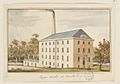
The sugar works, 1840s
-
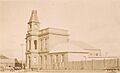
Canterbury Town Hall
-
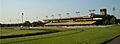
Canterbury Park Racecourse
-
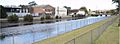
Former industrial area along Cooks River
-
Former Canterbury Post Office building
-
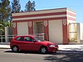
Art-deco amenities building
-
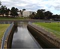
Junction of Cooks River and Cup and Saucer Creek, with old sugarmill in the background


