
City of Canterbury (New South Wales) facts for kids
Quick facts for kids City of CanterburyNew South Wales |
|||||||||||||||
|---|---|---|---|---|---|---|---|---|---|---|---|---|---|---|---|

Location in Metropolitan Sydney
|
|||||||||||||||
| Population | 146,314 (2012) | ||||||||||||||
| • Density | 4,303.45/km2 (11,145.9/sq mi) | ||||||||||||||
| Established | 17 March 1879 (Municipality) 16 November 1993 (City) |
||||||||||||||
| Abolished | 12 May 2016 | ||||||||||||||
| Area | 34 km2 (13.1 sq mi) | ||||||||||||||
| Mayor | Brian Robson (Labor Labor) | ||||||||||||||
| Council seat | Canterbury Administration Building, Campsie | ||||||||||||||
| Region | Inner West South West |
||||||||||||||
| Website | City of Canterbury | ||||||||||||||
|
|||||||||||||||
The City of Canterbury was a special area in Sydney, New South Wales, Australia, that had its own local government. It was located in the south-west part of Sydney. This city was mostly made up of homes and some small factories. It was also a place where people from over 130 different countries lived! Many people who lived there were born overseas, so it was known as the "City of Cultural Diversity." It started as the Municipality of Canterbury in 1879 and became the City of Canterbury in 1993.
The last leader, called the Mayor, was Brian Robson. The City of Canterbury Council stopped existing on 12 May 2016. It joined with the City of Bankstown to form a new, bigger council called the City of Canterbury-Bankstown.
Contents
What Suburbs Were in Canterbury?
The City of Canterbury included many suburbs. Here are some of the main ones:
- Ashbury
- Belfield
- Belmore
- Beverly Hills
- Campsie
- Canterbury
- Clemton Park
- Croydon Park
- Earlwood
- Hurlstone Park
- Kingsgrove
- Lakemba
- Narwee
- Punchbowl
- Riverwood
- Roselands
- Wiley Park
A Look Back: History of Canterbury

Long before European settlers arrived, Indigenous Australians lived in this area for thousands of years. In 1770, explorers from the ship HM Bark Endeavour explored the land along the Cooks River. In 1793, the first land grant was given to Reverend Richard Johnson, who was the chaplain of the First Fleet. He named the area Canterbury Vale.
More homes started to be built in the 1880s. A train line was extended to Canterbury in 1895. This helped more people move to the area, and it became very populated.
Local residents asked the State Government for their own council. So, the Municipality of Canterbury was officially created on 17 March 1879. The council first met in the home of the first mayor, John Sproule. The Canterbury Town Hall opened in 1889. Later, in 1963, the main council office moved to Campsie. On 16 November 1993, the area was officially named the City of Canterbury.
Why Did Canterbury Merge?
In 2015, the NSW Government looked at how local government areas were set up. They suggested that the City of Canterbury should join with the City of Bankstown. This would create a new, larger council. On 12 May 2016, the merger happened. This created the new City of Canterbury-Bankstown council.
Who Lived in Canterbury? (Demographics)
At the 2011 Census, about 137,454 people lived in the City of Canterbury. The average age of people living there was 35 years old. About 20% of the population were children aged 0 to 14 years.
The City of Canterbury was known for its many different cultures. The top five backgrounds people identified with were:
Many different languages were spoken at home, besides English. The most common languages were:

| People in Canterbury (2001-2011) | |||||
|---|---|---|---|---|---|
| Census year | 2001 | 2006 | 2011 | ||
| Population | Number of residents | 129,935 | 129,963 | 137,454 | |
| % of New South Wales population | 1.99% | ||||
| % of Australian population | 0.69% | ||||
| Cultural and language diversity | |||||
| Ancestry, top responses |
Chinese | 11.6% | |||
| Australian | 9.7% | ||||
| Lebanese | 9.5% | ||||
| Greek | 9.5% | ||||
| English | 8.9% | ||||
| Language, top responses (other than English) |
Arabic | 12.2% | |||
| Greek | 11.1% | ||||
| Mandarin | 1.7% | ||||
| Cantonese | 2.7% | ||||
| Vietnamese | n/c | ||||
| Religious affiliation | |||||
| Religious affiliation, top responses |
Catholic | 43.4% | |||
| Islam | 5.1% | ||||
| Eastern Orthodox | 15.8% | ||||
| No religion | 11.1% | ||||
| Buddhism | n/c | n/c | |||
| Median weekly incomes | |||||
| Personal income | Average weekly personal income | A$366 | A$430 | ||
| Household income | Average weekly household income | A$1,007 | A$1,029 | ||
Symbols of Canterbury: Coat of Arms and Logo
_coat_of_arms,_granted_1979.jpg) |
|
The City of Canterbury had its own special symbols, like a coat of arms and a logo.
What Was the Logo Like?
The council's logo, used until 2016, had two "C" shapes in black and white. These were crossed by a light blue wave. This wave represented the Cooks River, which flows through the area.
Friends Around the World: Sister Cities
The City of Canterbury had "sister city" relationships with two places in other countries. This means they shared cultural and friendly ties.
 Eunpyong-gu, Seoul, South Korea. A special garden in Campsie was made in 2000 to celebrate this friendship, which started in 1988.
 Patras, Greece.
Images for kids
-
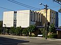
The Administration Building in Campsie. This was the main office for Canterbury Council from 1963 to 2016.
-
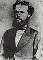
John Sproule (1838–1905) was the first Mayor of Canterbury from 1879 to 1880.


