
Earlwood, New South Wales facts for kids
Quick facts for kids EarlwoodSydney, New South Wales |
|||||||||||||||
|---|---|---|---|---|---|---|---|---|---|---|---|---|---|---|---|

Earlwood Hotel, Homer Street in 2006
|
|||||||||||||||
| Population | 18,053 (2021 census) | ||||||||||||||
| Established | 1829 | ||||||||||||||
| Postcode(s) | 2206 | ||||||||||||||
| Elevation | 51 m (167 ft) | ||||||||||||||
| Location | 10 km (6 mi) SW of Sydney CBD | ||||||||||||||
| LGA(s) | City of Canterbury-Bankstown | ||||||||||||||
| State electorate(s) | Canterbury | ||||||||||||||
| Federal Division(s) | Barton | ||||||||||||||
|
|||||||||||||||
Earlwood is a suburb in Sydney, New South Wales, Australia. It is about 10 kilometres south-west of the Sydney city centre. Earlwood is part of the Canterbury-Bankstown area. It is managed by the City of Canterbury-Bankstown local council.
Earlwood stretches from the Cooks River in the north to Wolli Creek in the south. Suburbs like Wolli Creek, Turrella, and Bardwell Park are to the south. Canterbury, Hurlstone Park, and Marrickville are to the north and east. Clemton Park is to the west. Earlwood is mostly a place where people live. It has some shops and businesses along Homer Street, which is its main road.
Contents
History of Earlwood
How Earlwood Began
Earlwood started as a piece of land given to John Parkes in 1827. In 1829, John Parkes and his sons had a logging camp here. They cut down trees on their 50-acre land. This area was first called Parkes Camp, then Parkestown. Later, around 1905-1906, it was named Forest Hill. Finally, in 1918, it became known as Earlwood.
Frederick Wright Unwin bought land in the Undercliffe area in 1840. He built his home there and called it Wanstead. To cross the Cooks River, people first used a small boat called a punt. Later, a wooden bridge was built. The road leading to it became Unwins Bridge Road. You can still find the name Wanstead in Wanstead Avenue and Wanstead Reserve today.
Earlwood After World War I
After World War I, a special area was set up for soldiers who had returned from the war and their families. This area was west of Wardell Road. The streets there are named after famous people and battles from the war. Some names include Kitchener, Hamilton, Vimy, and Polygon.
From 1912 to 1957, electric trams ran along Homer Street to Earlwood. They took people to the city through Marrickville and Newtown. Now, buses provide this service. Since the 1960s, more and more people of Greek background have moved to Earlwood.
Heritage Sites in Earlwood
Earlwood has some places that are important for their history. These are called heritage-listed sites. They include:
- Pine Street: Cooks River Sewage Aqueduct (a bridge that carries water pipes)
- Unwin Street: Wolli Creek Aqueduct (another water pipe bridge)
- Earlwood Aboriginal Art Site (a place with ancient Aboriginal art)
Shopping and Services
The main shopping area in Earlwood is on Homer Street. It is about 500 metres up the hill from Bardwell Park railway station. You can also find a Coles supermarket and other shops on Clarke Street. Earlwood has many restaurants and cafes. You can find Greek, Thai, and other European foods there.
The place where the KFC is now used to be the home of former prime minister John Howard. His parents ran two petrol stations nearby. Long ago, Homer Street had two cinemas called The Chelsea and The Mayfair. The Earlwood Hotel is on the corner of Earlwood Avenue and Homer Street.
The Earlwood-Bardwell Park RSL club is near Bardwell Park railway station. The Earlwood local library is on the corner of William Street and Homer Street. There is an old, heritage-listed post box outside the library.
Getting Around Earlwood
Earlwood has many bus routes. These buses are run by Transit Systems and U-Go Mobility.
There are no train stations right in Earlwood. However, you can find train stations nearby. Bexley North, Bardwell Park, and Turrella stations are just across Wolli Creek to the south. Canterbury, Hurlstone Park, and Dulwich Hill stations are to the north and east, across the Cooks River.
Churches in Earlwood
Earlwood has several churches for different faiths:
- Our Lady of Lourdes Catholic Church
- St Georges Anglican Church
- Earlwood Presbyterian Church
- Earlwood Uniting Church
- Earlwood Baptist Church
- The Salvation Army Earlwood
- The Transfiguration of Our Lord Greek Orthodox Church
Parks and Green Spaces
Earlwood has many parks and green areas for everyone to enjoy.
- Gough Whitlam Park and Waterworth Reserve are near Tempe station. You can find a bicycle velodrome here. The "Clean Up Australia Day" event first started on the banks of the Cooks River here. The Cooks River Festival is also held here every year.
- Heynes Reserve and Sutton Reserve are quiet places near the Cooks River. Sutton Reserve has a playground.
- Hughes Park is a large area for sports and other activities.
- Beaman Park and Wills Ground are further along the Cooks River. They have sports fields, bike paths, and BBQ areas. Beaman Park is home to the Earlwood Wanderers soccer club. Wills Ground is home to the Canterbury Rugby Union Club.
- Earlwood Oval is a local park and sports ground. It is used for lawn bowls, cricket, soccer, and football.
- Girrawheen Park is a big park along Wolli Creek. It has great views of nearby suburbs. This park has special bushland that is protected.
- Wanstead Reserve is named after an old property from the 1840s.
- Nanny Goat Hill (also called Prickly Pear Hill) was almost dug up for airport construction in the 1960s. But some local people, Harold May, Peter Ridsdale, and Carl Lyons, worked together to save it. They succeeded, and now it's a valued recreation area. Beaman Park is named after the mayor who helped them.
People of Earlwood
Earlwood is a very multicultural place. It has a large number of people with Greek-Australian backgrounds. In the past, many Greek families lived in Marrickville. But later, many moved to suburbs like Earlwood, looking for bigger homes.
According to the 2021 census, there were 18,053 people living in Earlwood. The most common backgrounds reported were Greek (22.3%), Australian (16.9%), and English (14.9%). About 61.9% of people were born in Australia. Other common birthplaces include Greece (7.4%), China (3.0%), and Portugal (2.4%).
About half of the people (49.8%) speak only English at home. Other languages spoken include Greek (18.1%), Arabic (5.6%), and Italian (3.4%). For religion, the most common choices were Catholic (29.0%), No Religion (24.4%), and Orthodox (24.2%).
Famous People from Earlwood
Some well-known people have lived in Earlwood:
- Josh Addo-Carr, a rugby league player
- Alex Dimitriades, an actor
- Blake Ferguson, a former rugby league player
- John Howard, a former Prime Minister of Australia
Earlwood's Landscape
Earlwood's land stretches from a tall cliff on the south bank of the Cooks River in the northeast. This area is called Undercliffe. The suburb goes west along the Cooks River, where the land becomes flatter. Wolli Creek forms the southern border of Earlwood. The train line runs along the Wolli Creek valley, just outside Earlwood. This provides the closest train access for people living in the suburb.
Earlwood's Place in Sydney
Earlwood is often seen as part of South Western Sydney or the Canterbury-Bankstown region. However, it is at the very eastern end of this area. It is separated from Marrickville by the Cooks River. Marrickville is part of the Inner West region. Because of this, Earlwood is sometimes also called part of the Inner West.
Earlwood shares many similarities with its neighbours to the west and south. For example, it has many residents of Greek heritage. This is similar to Bardwell Park and Clemton Park.
Images for kids
-
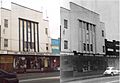
Earlwood Wines (left, 2000s) and Chelsea Theatre (right, 1950s)
-
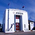
Acropolis Funeral services in a former bank building on Homer Street
-
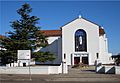
Our Lady of Lourdes Catholic Church
-
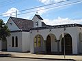
The Transfiguration of Our Lord Greek Orthodox Church
-
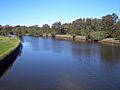
Cooks River, between Marrickville and Earlwood
-
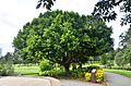
Tree at Gough Whitlam Park, Earlwood 2018
-
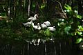
White ducks sunbathing at Gough Whitlam Park, Earlwood 2018
-
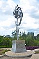
Statue of respect, unity & peace at Gought Whitlam Park 2018
-
Women in traditional dress at Ubhauli Kirati festival 2017 at Gough Whitlam Park, Earlwood


