Undercliffe, New South Wales facts for kids
Quick facts for kids UndercliffeSydney, New South Wales |
|
|---|---|

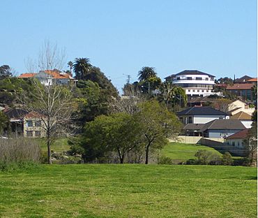
View of Undercliffe from Waterworth Park
|
|
| Postcode(s) | 2206 |
| Location | 10 km (6 mi) south-west of Sydney CBD |
| LGA(s) | City of Canterbury-Bankstown |
| State electorate(s) | Canterbury |
| Federal Division(s) | Barton |
Undercliffe is a part of the suburb of Earlwood in South Western Sydney, New South Wales, Australia. It is located about 10 kilometres south-west of the main city area of Sydney. Undercliffe is managed by the City of Canterbury-Bankstown local council.
Contents
History of Undercliffe
Early Days: The 1800s
Undercliffe was first known as the Undercliffe Estate in the 1840s. This was because there were already some homes built there. The name "Undercliffe" comes from a large rock formation called Sydney sandstone. This type of rock is found all over the greater Sydney area.
Quarrying, which means digging up, this sandstone was the first main industry in the area. The sandstone was dug up between Wolli Creek and Cooks River. This rock was used to build many more homes.
A famous landowner from this time was James Donnithorne. He was a judge for the East India Company. He owned parts of the Undercliffe Estate. When he passed away, his daughter, Eliza Emily Donnithorne, took over the land. She rented out the land until she died. After that, the land was sold and divided into smaller pieces for housing.
In 1836, a wooden bridge was built over the Cooks River. It helped people travel along Illawarra Road. This bridge was called Tompsons Bridge. It was named after the father of Mr. P. A. Tompson. The bridge was washed away many times by floods.
Later, a man named Unwin bought land in the area in 1840. He built a large home called Wanstead. Today, you can still find names like Unwins Bridge, Unwins Bridge Road, Wanstead Avenue, and Wanstead Avenue Reserve in the area.
The 1900s and Beyond
Waterworth Park was made a special reserve in 1906. This was because the land was not good for building homes due to health reasons.
From 1912 to 1957, electric trams ran through Undercliffe. They traveled along Illawarra Road and Homer Street to the west of Earlwood. These trams connected the area to the city through Marrickville and Newtown. Now, buses provide this transport service.
Undercliffe used to be its own separate suburb in Sydney. But in 1993, it became part of Earlwood.
Geography and Surroundings
Undercliffe is mostly a place where people live. It is located on a piece of land that has water on two sides. The Cooks River is on one side, and Wolli Creek is on the other. The northern part of Undercliffe has many parks and places for fun activities.
Bayview Avenue and Unwins Bridge connect Undercliffe north over the Cooks River to Tempe. Another bridge on Illawarra Road crosses the Cooks River to Marrickville.
Wolli Creek and Turrella are on the other side of Wolli Creek. You can only reach these suburbs directly by footbridges.
Important Places to See
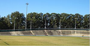
- Canterbury Velodrome at Waterworth Park (a velodrome is a track for bicycle racing)
- Gough Whitlam Park
- The Transfiguration of Our Lord Greek Orthodox Church (a church for Greek Orthodox Christians)
- Undercliffe Public School
Historic Sites
Undercliffe has several places that are protected because of their history:
- Pine Street: Cooks River Sewage Aqueduct (a structure that carries water or sewage over a river)
- Unwin Street: Wolli Creek Aqueduct
Ancient Rock Art Site
There is also a special site with rare hand and feet stenciling rock art. This art was made by the original inhabitants of the land. This site is on private property and is not open to the public.
 | Victor J. Glover |
 | Yvonne Cagle |
 | Jeanette Epps |
 | Bernard A. Harris Jr. |


