
Turrella, New South Wales facts for kids
Quick facts for kids TurrellaSydney, New South Wales |
|||||||||||||||
|---|---|---|---|---|---|---|---|---|---|---|---|---|---|---|---|

Cairnsfoot, Loftus Street c. 2005
|
|||||||||||||||
| Population | 2,673 (2021 census) | ||||||||||||||
| Postcode(s) | 2205 | ||||||||||||||
| Elevation | 15 m (49 ft) | ||||||||||||||
| Location | 10 km (6 mi) south-west of Sydney CBD | ||||||||||||||
| LGA(s) | Bayside Council | ||||||||||||||
| State electorate(s) | Rockdale | ||||||||||||||
| Federal Division(s) | Barton | ||||||||||||||
|
|||||||||||||||
Turrella is a suburb located in southern Sydney, New South Wales, Australia. It is about 10 kilometers (6 miles) south-west of the Sydney central business district (CBD). Turrella sits on the southern side of Wolli Creek and is part of the Bayside Council area.
Turrella is mostly a place where people live. There are also some light industrial areas, especially near the Turrella railway station. A special footbridge crosses Wolli Creek, connecting Henderson Street in Turrella to the eastern part of Earlwood. This bridge was closed for a while but was fixed and reopened in 2013.
Contents
A Look at Turrella's Past
In 1842, a family named Favell farmed land here. Their neighbors, the Curtis and Blackwell families, grew fruits and vegetables. When the railway arrived, these farms were divided into smaller pieces of land.
How Turrella Grew
The railway station in Turrella opened on September 21, 1931. Many factories were built close to the railway line. One of the biggest factories was the Streets Ice Cream factory, which made delicious ice cream! This factory has now closed down.
The local post office has had a few different names over the years. It first opened in 1933 as West Arncliffe. Later, it was called Arncliffe West, and then in 1952, it became Turrella. The post office closed in 1970.
Important Historical Places
Turrella is next to a beautiful natural area called the Wolli Creek Valley. This valley has lots of native bushland. People have worked hard to protect this area from being built on. For example, they successfully stopped a major road, the M5 South Western Motorway, from being built through the valley. Instead, the road was built as a tunnel underneath it.
Turrella also has some buildings and places that are important to its history. These are called heritage-listed sites:
- 18 Loftus Street: This is where a building called Cairnsfoot is located.
- Thompson Street: Here you can find the Wolli Creek Aqueduct, which is an old water channel.
Who Lives in Turrella?
In 2021, about 2,673 people lived in Turrella. People from many different backgrounds call Turrella home. The most common family backgrounds are Lebanese, Chinese, Australian, English, and Macedonian.
About 45% of the people living in Turrella were born in Australia. Other people were born in countries like China and Lebanon. Many different languages are spoken at home, including Arabic, Mandarin, Spanish, Macedonian, and Cantonese. When it comes to religion, many people in Turrella do not have a religion, while others are Muslim or Catholic.
Schools in Turrella
Arncliffe West Infants School is located on Loftus Street. Right across the street is the old building of Cairnsfoot Special School. The original Cairnsfoot building is very old and is considered a heritage site.
Getting Around Turrella
Train and Bus Services
Turrella railway station is part of the Sydney Trains network, on the Airport & South Line. This makes it easy to travel to other parts of Sydney.
There is also a bus route, number 473, that goes through Turrella. This bus connects Rockdale station to Campsie station. It travels through several suburbs like Bardwell Valley, Arncliffe, and Earlwood.
Motorway Access
The M5 South Western Motorway runs underneath parts of Turrella in a long tunnel. This motorway helps people travel quickly to places like Beverly Hills and Liverpool to the south-west. It also connects to Botany and the city to the north-east.
Images for kids
-
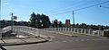
Turrella railway bridge
-
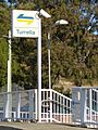
Turrella railway station entrance


