
Arncliffe, New South Wales facts for kids
Quick facts for kids ArncliffeSydney, New South Wales |
|||||||||||||||
|---|---|---|---|---|---|---|---|---|---|---|---|---|---|---|---|

Arncliffe Post Office
|
|||||||||||||||
| Population | 12,023 (2021 census) | ||||||||||||||
| • Density | 3,340/km2 (8,700/sq mi) | ||||||||||||||
| Established | 1840 | ||||||||||||||
| Postcode(s) | 2205 | ||||||||||||||
| Area | 3.6 km2 (1.4 sq mi) | ||||||||||||||
| Location | 11 km (7 mi) south of Sydney CBD | ||||||||||||||
| LGA(s) | Bayside Council | ||||||||||||||
| State electorate(s) | Rockdale | ||||||||||||||
| Federal Division(s) | Barton | ||||||||||||||
|
|||||||||||||||
Arncliffe is a suburb located in southern Sydney, in the state of New South Wales, Australia. It is about 11 kilometres south of the main city centre of Sydney. Arncliffe is part of the Bayside Council area.
This suburb is found south of the Cooks River and Wolli Creek, and it's quite close to Sydney Airport. Arncliffe is mostly a place where people live, with many houses and some apartment buildings. There are also areas with shops and light industries.
Contents
Arncliffe's Story: A Look Back in Time
Arncliffe got its name from a small village called Arncliffe in North Yorkshire, England. The name 'Arneclif' means 'Eagle Cliff'.
In 1840, an early land developer named William Hirst created a new area called The Village of Arncliffe Estate. William Hirst was from Yorkshire, England, and it's believed he named the area after the pretty village of Arncliffe there. It took over 20 years for the name to be officially recognised.
Local leader E.G. Barton helped develop the area. He even helped turn 120 acres (about 0.5 square kilometres) of swampland into what is now Barton Park and Kogarah Golf Links.
In November 1910, some land lots were sold in an area called the 'Radium Estate'. This area was bordered by Wentworth, Cook, and Dowling streets.
First People of Arncliffe
The original people living in this area were Indigenous Australians. Evidence suggests they belonged to the Gweagal, Bidjigal, and Cadigal clans. You can still find signs of their presence, like smoke-blackened caves, in the valleys of local creeks like Wolli Creek and Bardwell Creek.
Long ago, Arncliffe Hill was known as Cobbler's Hill. The area became like a big vegetable garden for Sydney. Many small farms grew here, spreading towards Black Creek. In 1843, newspapers advertised that there was "money to be made by woodcutters and farming men" in the area.
Old Homes and Buildings
Arncliffe used to have many grand Victorian-era houses. While some have been taken down or changed, efforts are now being made to protect these old buildings as part of the area's history.
For example, Dappeto on Wollongong Road was built in 1885. It was once a home for children and is now part of a nursing home. The Arncliffe Post Office, a beautiful Federation-style building, opened in 1906 and used to have the postmaster's home upstairs.
Over the years, Arncliffe has been home to different industries. In the 20th century, especially after World War II, there were many factories. These included the Streets Ice Cream factory and Fontana Films, where the famous Australian film "Jedda" was made. Both of these have now closed.
Important Historical Places
Arncliffe has several places that are listed for their historical importance:
- Firth Street: Arncliffe railway station
- 1 Princes Highway (now in Wolli Creek): Tempe House and St Magdalenes Chapel
- Valda Avenue (off south side of Kogarah Golf Course): Western Outfall Main Sewer
- 171 Wollongong Road: Dappeto
Shopping and Businesses
Arncliffe's main shopping area is around Firth Street and Belmore Street, right next to Arncliffe railway station. Shops also stretch along Forest Road and Wollongong Road. You'll find commercial and light industrial businesses in the northern parts of the suburb and along the Princes Highway.
Getting Around Arncliffe

The Princes Highway is a major road that goes north towards the city and south towards Rockdale and Kogarah. Other important roads include Forest Road and Wollongong Road. The M5 South Western Motorway also runs nearby, with a 4-kilometre tunnel partly underneath Arncliffe.
Arncliffe railway station is on the Illawarra line of the Sydney Trains network, making it easy to travel by train.
Buses also serve Arncliffe, with routes 473, 420, and 420N. These buses connect Arncliffe to places like Rockdale, Earlwood, Campsie, Sydney Airport, and Burwood.
Places of Worship
Arncliffe is home to several different places of worship:
- St David's Anglican Church on Forest Road.
- St Francis Xavier's Catholic Church on Forest Road.
- Saint Marks Coptic Orthodox Cathedral on Wollongong Road.
- Al-Zahra Mosque at the end of Wollongong Road.
- Masjid Darul Imaan Mosque on Eden Street.
- Bay City Church on Hattersley Street.

Schools in Arncliffe
Arncliffe has several schools for different ages:
- Arncliffe Public School is on the corner of Avenal Street and the Princes Highway.
- Athelstane Public School is on the corner of Wollongong Road and Athelstane Avenue.
- Arncliffe West Infants School on Loftus Street is actually in the nearby suburb of Turrella.
- St Francis Xavier's Catholic School is next to the church on Forest Road.
- Al-Zahra College is next to the mosque on Wollongong Road.
- Kingdom Culture Christian School is on the corner of Dowling Street.
Parks and Recreation

Arncliffe has several parks where people can enjoy outdoor activities:
- Arncliffe Park is a popular spot for local teams playing Cricket, Rugby league, and Soccer. The Arncliffe War Memorial is also located here.
- Cahill Park and Barton Park offer more recreational facilities.
- Kogarah Golf Course is nearby for golf enthusiasts.
Arncliffe's Earl Park was once the home ground for the New South Wales Rugby Football League Premiership club, St. George, from 1925 to 1939. It was also the site of a famous event known as the 1928 Earl Park riot.
Community and Social Life
Arncliffe has a few social venues where people can gather:
- Arncliffe RSL
- Arncliffe Scots Sports & Social Club
- Rowers on Cooks River (formerly the St George Rowing Club)
- Kogarah Golf Club
Who Lives in Arncliffe?
Based on the 2021 census, Arncliffe had a population of 12,023 people.
- About 44.8% of people were born in Australia. Other common countries of birth included China (5.9%), Lebanon (5.7%), Mongolia (3.0%), North Macedonia (2.9%), and the Philippines (2.1%).
- For languages spoken at home, 35.8% of people spoke only English. Other common languages included Arabic (14.6%), Mandarin (6.3%), Macedonian (4.3%), Spanish (3.3%), and Mongolian (3.0%).
- When it comes to religion, the most common responses were No Religion (28.1%), Islam (19.4%), and Catholic (16.7%).
Geography and Nearby Areas
Wolli Creek and Bardwell Valley
The area north of Arncliffe, which used to be part of it, officially became the separate suburb of Wolli Creek in 2002. This area has seen a lot of new apartment buildings.
Bardwell Valley also became a new suburb in 1996. It was formed from parts of Arncliffe that are next to Bardwell Creek. Bardwell Park was named after Thomas Hill Bardwell, who owned land there.
Local Landmarks
Here are some important landmarks in Arncliffe:
- Arncliffe Railway Station on Firth Street
- Arncliffe Fire Station on West Botany Street
- Arncliffe Library on Firth Street
- Arncliffe Community Centre, Arncliffe YMCA, and Coronation Hall on Barden Street
- St George School Education Area Office on Segenhoe Street
See Also
Images for kids
-
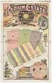
Radium Estate, Arncliffe 1910
-
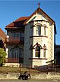
Former St Francis Xavier presbytery
-
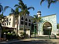
Al-Zahra Mosque
-
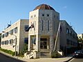
Al-Zahra College


